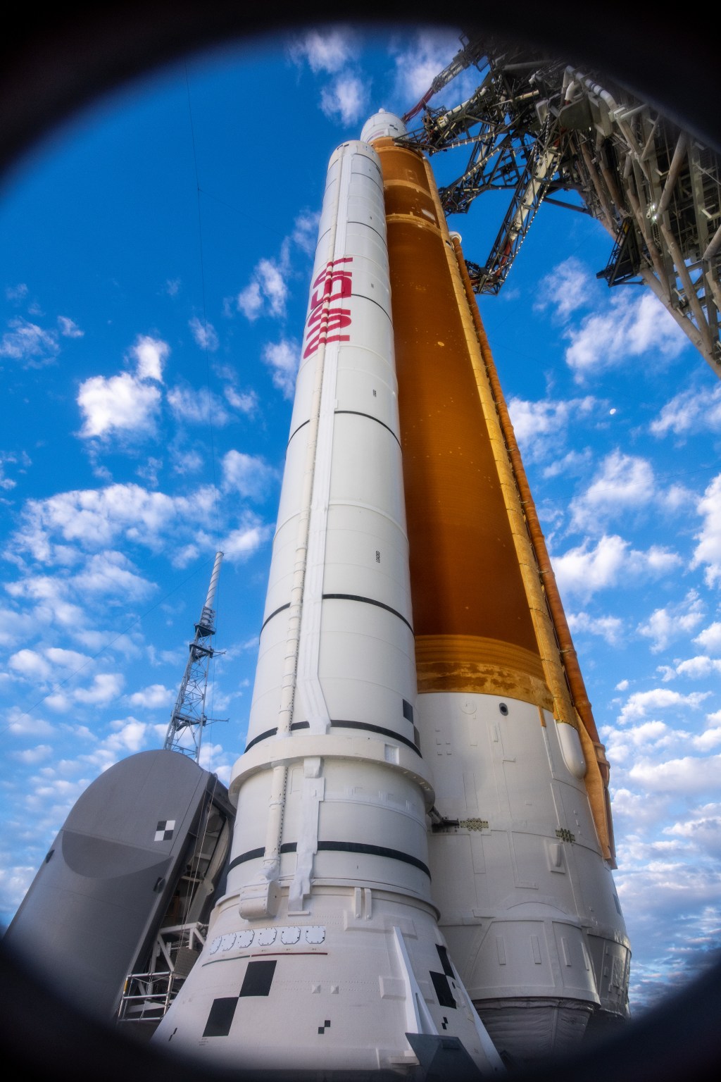
Preparations for Next Moonwalk Simulations Underway (and Underwater)
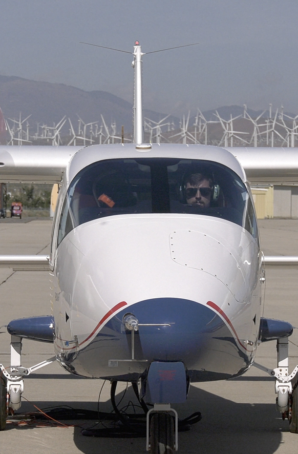
Boeing’s test plane simulates digital taxiing at Moffett Field at NASA’s Ames Research Center in California’s Silicon Valley.
NASA/Brandon Torres Navarrete
New technology tested by an industry partner at NASA’s Ames Research Center in California’s Silicon Valley could improve how commercial planes taxi to and from gates to runways, making operations safer and more efficient on the surfaces of airports.
Airport taxiways are busy. Planes come and go while support vehicles provide maintenance, carry fuel, transport luggage, and more. Pilots must listen carefully to air traffic control when getting directions to the runway – and garbled communications and heavy workloads can cause issues that could lead to runway incursions or collisions.
Researchers at Boeing are working to address these issues by digitizing taxiway information and automating aircraft taxi functions. The team traveled to NASA Ames to collaborate with researchers while testing their technology at the Moffett Federal Airfield and NASA’s FutureFlight Central, an air traffic control simulation facility.
Doug Christensen, test engineer for Air Traffic Management eXploration (ATM-X) at NASA Ames, and Mike Klein, autonomy technical leader in product development at Boeing discuss the digital taxi test in Ames’s FutureFlight Central facility.
NASA/Brandon Torres Navarrete
To test these new technologies, Boeing brought a custom single-engine test plane to the airfield. Working from FutureFlight Central, their researchers developed simulated taxiway instructions and deployed them to the test pilot’s digital tablet and the autonomous system.
Typically, taxiing requires verbal communication between an air traffic controller and a pilot. Boeing’s digital taxi release system displays visual turn-by-turn routes and directions directly on the pilot’s digital tablet.
“This project with Boeing lends credibility to the research being done across Ames,” said Adam Yingling, autonomy researcher for the Air Traffic Management-eXploration (ATM-X) program at NASA Ames. “We have a unique capability with our proximity to Moffett and the work Ames researchers are doing to advance air traffic capabilities and technologies to support the future of our national airspace that opens the door to work alongside commercial operators like Boeing.”
The team’s autonomous taxiing tests allowed its aircraft to follow the air traffic control’s digital instructions to transit to the runway without additional pilot inputs.
Estela Buchmann, David Shapiro, and Maxim Mounier, members of the NASA Ames ATM-X project team, analyze results of Boeing’s digital taxi test at Ames’s FutureFlight Central facility.
NASA/Brandon Torres Navarrete
As commercial air travel increases and airspace gets busier, pilots and air traffic controllers have to manage heavier workloads. NASA is working with commercial partners to address those challenges through initiatives like its Air Traffic Management-eXploration project, which aims to transform air traffic management to accommodate new vehicles and air transportation options.
“In order to increase the safety and efficiency of our airspace operations, NASA research in collaboration with industry can demonstrate how specific functions can be automated to chart the course for enhancing traffic management on the airport surface,” said Shivanjli Sharma, ATM-X project manager at Ames.
Preparations for Next Moonwalk Simulations Underway (and Underwater)
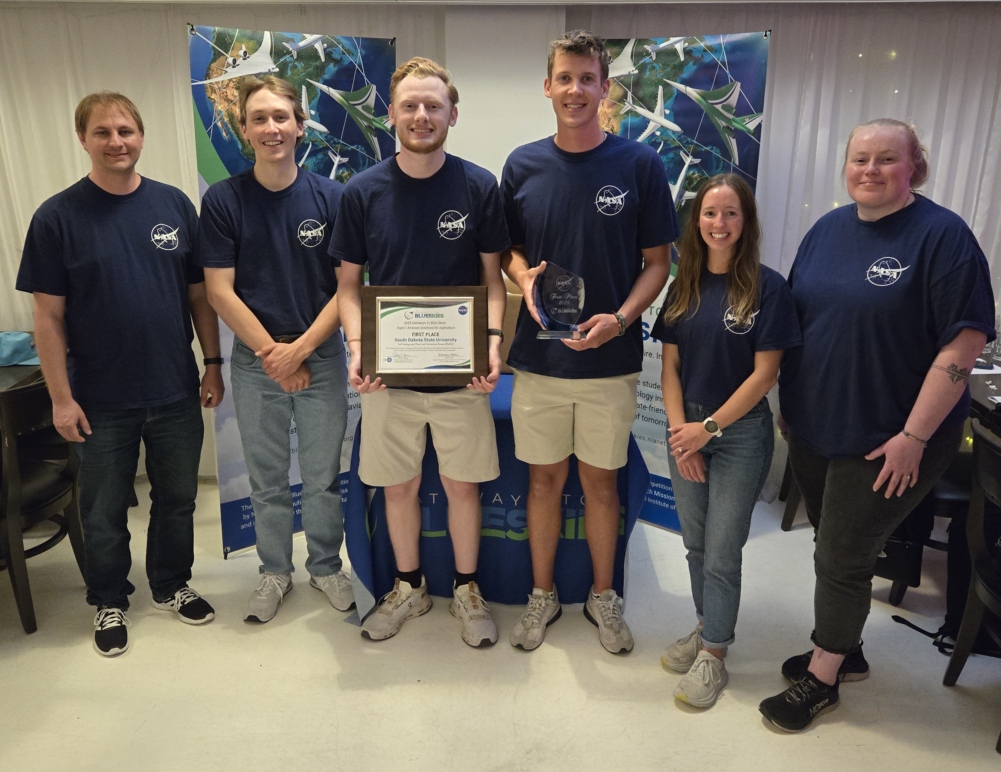
A team from South Dakota State University with their project, “Soil Testing and Plant Leaf Extraction Drone,” took first place at the 2025 Gateways to Blue Skies Forum held May 20-21 in Palmdale, California. Advisor Todd Lechter, left, along with team members Nick Wolles, Keegan Visher, Nathan Kuehl and Laura Peterson, and graduate advisor Allea Klauenberg, right, accepted the award.
NASA
A team from South Dakota State University, with their project titled “Soil Testing and Plant Leaf Extraction Drone” took first place at the 2025 NASA Gateways to Blue Skies Competition, which challenged student teams to research aviation solutions to support U.S. agriculture.
The winning project proposed a drone-based soil and tissue sampling process that would automate a typically labor-intensive farming task. The South Dakota State team competed among eight finalists at the 2025 Blue Skies Forum May 20-21 in Palmdale, California, near NASA’s Armstrong Flight Research Center. Subject matter experts from NASA and industry served as judges.
“This competition challenges students to think creatively, explore new possibilities, and confront the emerging issues and opportunity spaces solvable through aviation platforms,” said Steven Holz, assistant project manager for University Innovation with NASA’s Aeronautics Research Mission Directorate and Blue Skies judge and co-chair. “They bring imaginative ideas, interesting insights, and an impressive level of dedication. It’s always an honor to work with the next generation of innovators participating in our competition.”
This competition challenges students to think creatively, explore new possibilities, and confront the emerging issues and opportunity spaces solvable through aviation platforms
Steven holz
Assistant Project Manager for University Innovation
The winning team members were awarded an opportunity to intern during the 2025-26 academic year at any of four aeronautics-focused NASA centers — Langley Research Center in Hampton, Virginia, Glenn Research Center in Cleveland, Ames Research Center in California’s Silicon Valley, or Armstrong Flight Research Center in Edwards, California.
“It’s been super-rewarding for our team to see how far we’ve come, especially with all these other amazing projects that we were competing against,” said Nathan Kuehl, team lead at South Dakota State University. “It wouldn’t have been possible without our graduate advisor, Allea Klauenberg, and advisor, Todd Lechter. We want to thank everybody that made this experience possible.”
Other awards included:
Second Place — University of Tulsa, CattleLog Cattle Management System
Best Technical Paper — Boston University, PLAANT: Precision Land Analysis and Aerial Nitrogen Treatment
Sponsored by NASA’s Aeronautics Research Mission Directorate, this year’s competition asked teams of university students to research new or improved aviation solutions to support agriculture that could be applied by 2035 or sooner. The goal of the competition, titled AgAir: Aviation Solutions for Agriculture, was to enhance production, efficiency, sustainability, and resilience to extreme weather.
At the forum, finalist teams presented concepts of aviation systems that could help the agriculture industry.Students had the opportunity to meet with NASA and industry experts, tour NASA Armstrong, and gain insight into the agency’s aviation mission.
U.S. agriculture provides food, fuel, and fiber to the nation and the world. However, the industry faces significant challenges. NASA Aeronautics is committed to supporting commercial, industrial, and governmental partners in advancing aviation systems to modernize agricultural capabilities.
Preparations for Next Moonwalk Simulations Underway (and Underwater)
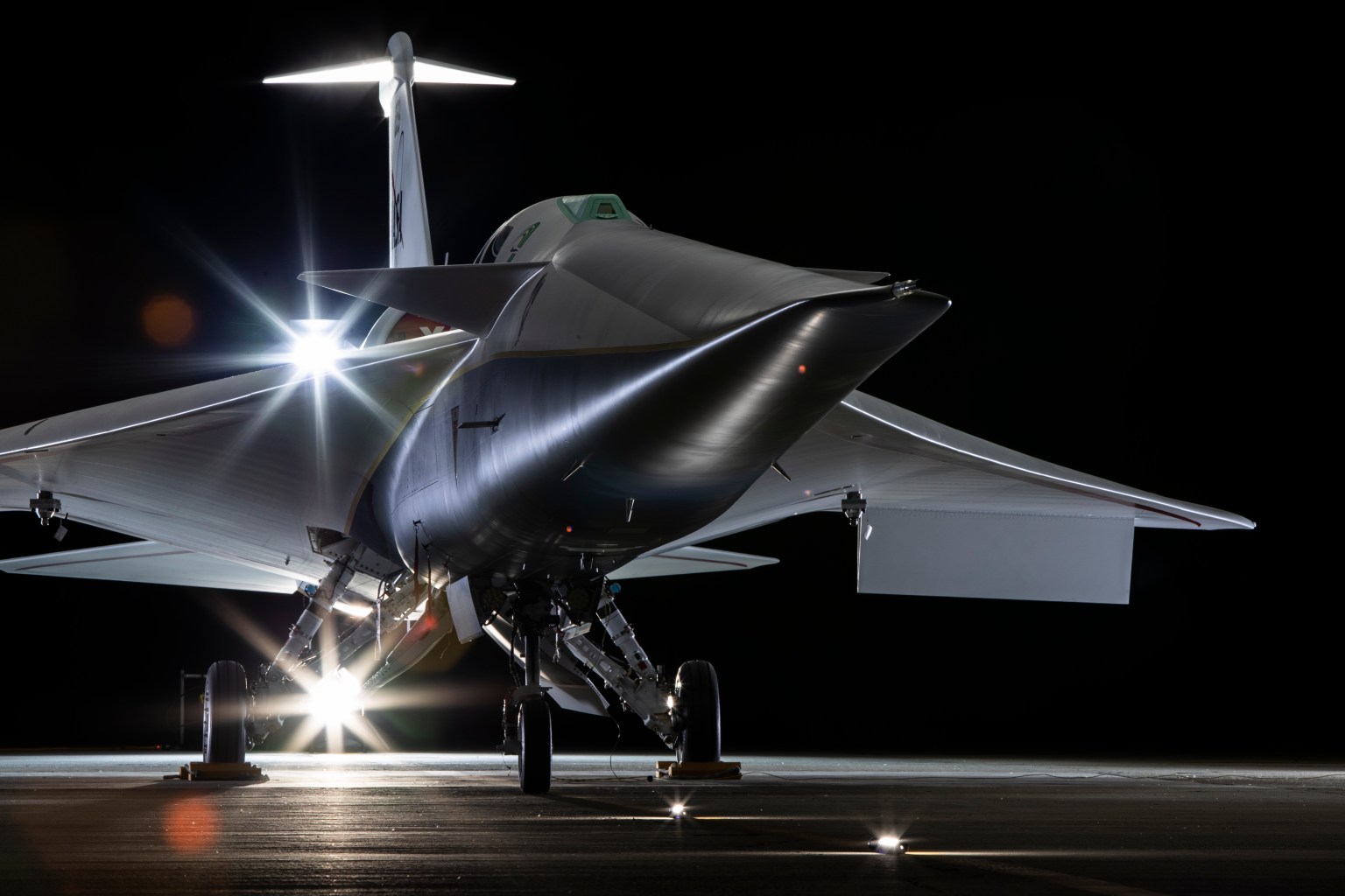
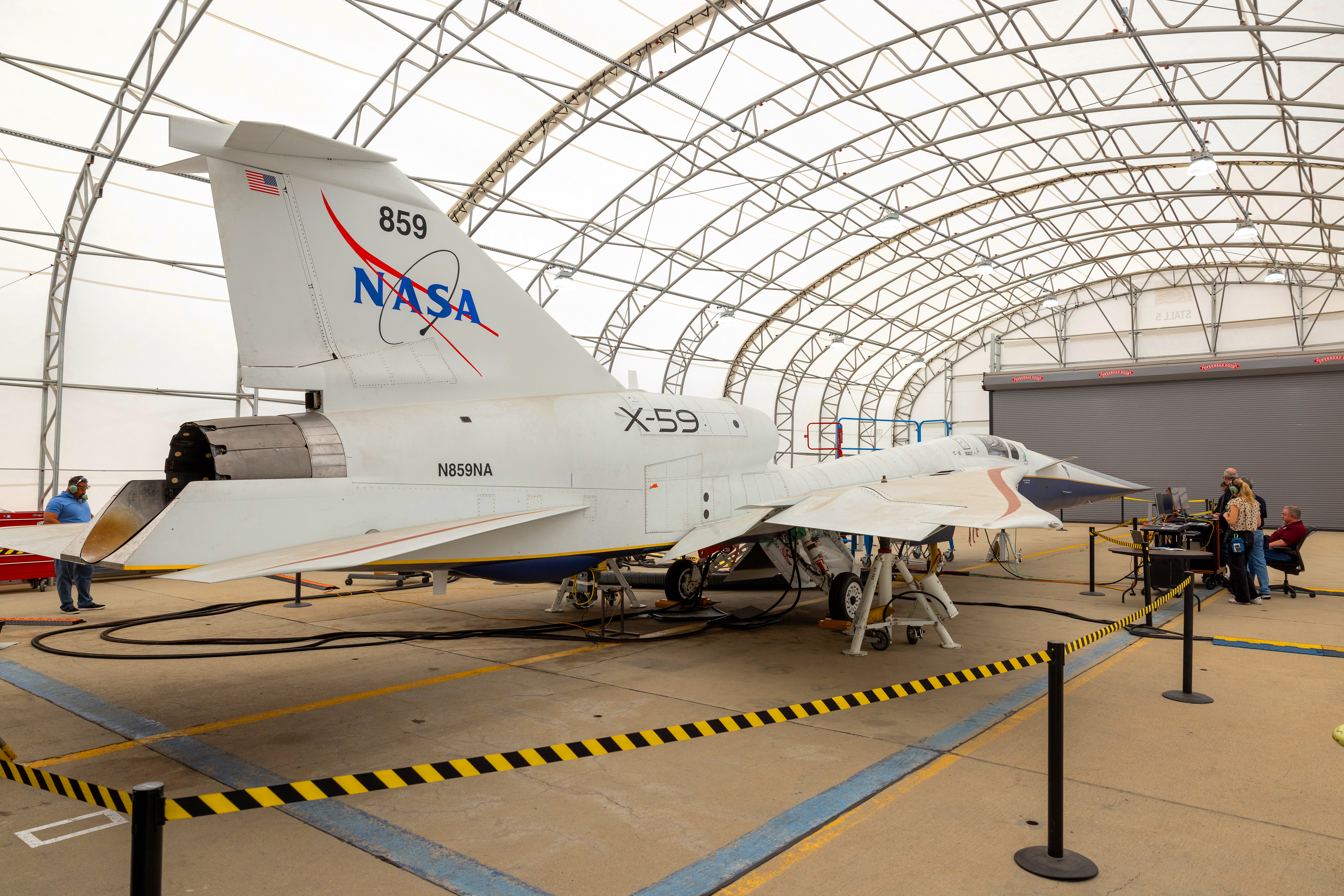
NASA’s X-59 quiet supersonic research aircraft is seen during its “aluminum bird” systems testing at Lockheed Martin’s Skunk Works facility in Palmdale, California. The test verified how the aircraft’s hardware and software work together, responding to pilot inputs and handling injected system failures.
Lockheed Martin / Garry Tice
NASA’s X-59 quiet supersonic research aircraft successfully completed a critical series of tests in which the airplane was put through its paces for cruising high above the California desert – all without ever leaving the ground.
“The idea behind these tests is to command the airplane’s subsystems and flight computer to function as if it is flying,” said Yohan Lin, the X-59’s lead avionics engineer at NASA’s Armstrong Flight Research Center in Edwards, California.
The goal of ground-based simulation testing was to make sure the hardware and software that will allow the X-59 to fly safely are properly working together and able to handle any unexpected problems.
Any new aircraft is a combination of systems, and identifying the little adjustments required to optimize performance is an important step in a disciplined approach toward flight.
“We thought we might find a few things during the tests that would prompt us to go back and tweak them to work better, especially with some of the software, and that’s what we wound up experiencing. So, these tests were very helpful,” Lin said.
Completing the tests marks another milestone off the checklist of things to do before the X-59 makes its first flight this year, continuing NASA’s Quesst mission to help enable commercial supersonic air travel over land.
Simulating the Sky
During the testing, engineers from NASA and contractor Lockheed Martin turned on most of the X-59’s systems, leaving the engine off. For example, if the pilot moved the control stick a certain way, the flight computer moved the aircraft’s rudder or other control surfaces, just as it would in flight.
At the same time, the airplane was electronically connected to a ground computer that sends simulated signals – which the X-59 interpreted as real – such as changes in altitude, speed, temperature, or the health of various systems.
Sitting in the cockpit, the pilot “flew” the aircraft to see how the airplane would respond.
“These were simple maneuvers, nothing too crazy,” Lin said. “We would then inject failures into the airplane to see how it would respond. Would the system compensate for the failure? Was the pilot able to recover?”
Unlike in typical astronaut training simulations, where flight crews do not know what scenarios they might encounter, the X-59 pilots mostly knew what the aircraft would experience during every test and even helped plan them to better focus on the aircraft systems’ response.
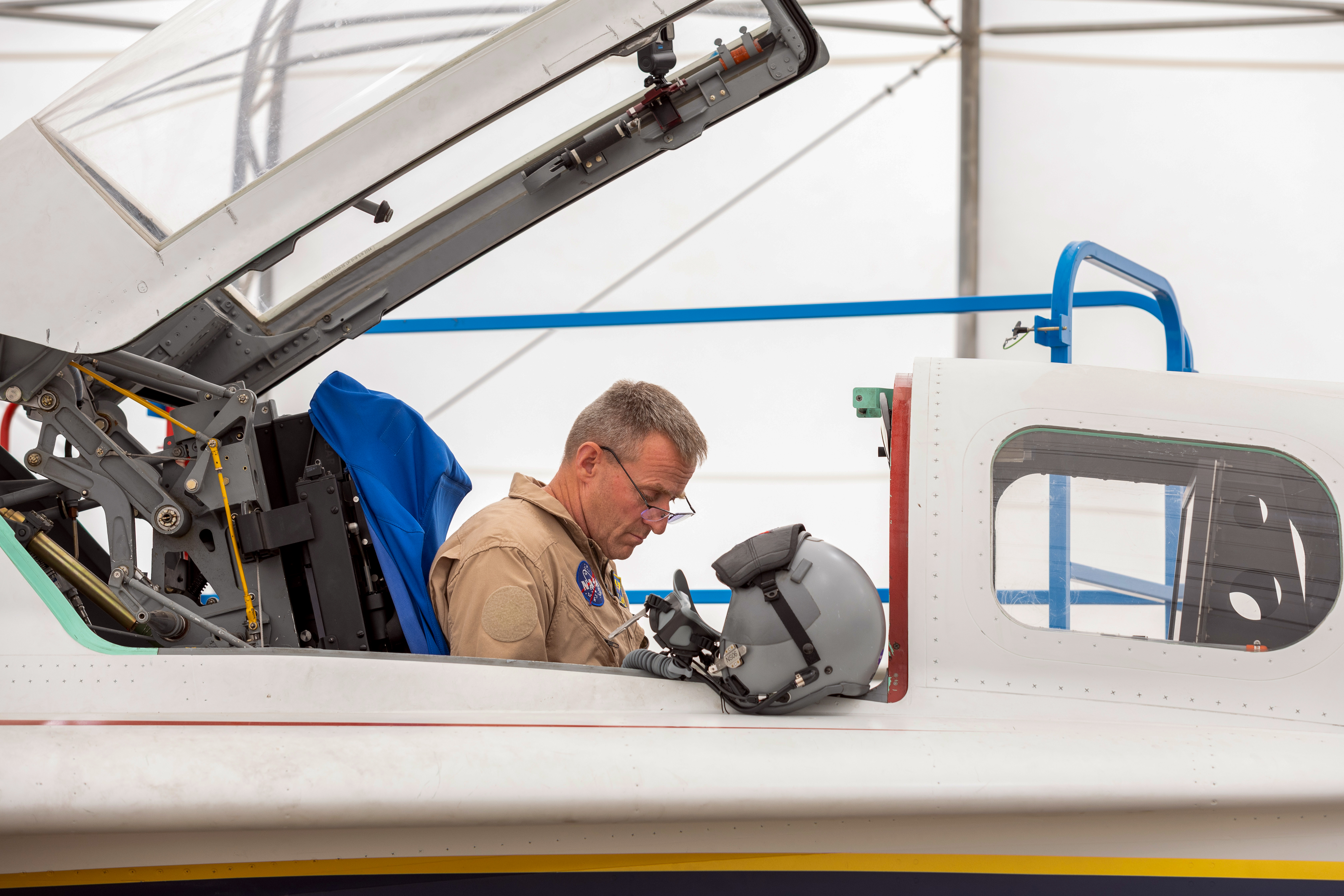
NASA test pilot James Less sits in the cockpit of the X-59 quiet supersonic research aircraft as he participates in a series of “aluminum bird” systems tests at Lockheed Martin’s Skunk Works facility in Palmdale, California.
Lockheed Martin / Garry Tice
Aluminum vs. Iron
In aircraft development, this work is known as “iron bird” testing, named for a simple metal frame on which representations of the aircraft’s subsystems are installed, connected, and checked out.
Building such a testbed is a common practice for development programs in which many aircraft will be manufactured. But since the X-59 is a one-of-a-kind airplane, officials decided it was better and less expensive to use the aircraft itself.
As a result, engineers dubbed this series of exercises “aluminum bird” testing, since that’s the metal the X-59 is mostly made of.
So, instead of testing an “iron bird” with copies of an aircraft’s systems on a non-descript frame, the “aluminum bird” used the actual aircraft and its systems, which in turn meant the test results gave everyone higher confidence in the design,
“It’s a perfect example of the old tried and true adage in aviation that says ‘Test what you fly. Fly what you test,’” Lin said.
Still Ahead for the X-59
With aluminum bird testing in the rearview mirror, the next milestone on the X-59’s path to first flight is take the airplane out on the taxiways at the airport adjacent to Lockheed Martin’s Skunk Works facility in Palmdale, California, where the X-59 was built. First flight would follow those taxi tests.
Already in the X-59’s logbook since the fully assembled and painted airplane made its public debut in January 2024:
Firing up the GE Aerospace jet engine for the first time after installation into the X-59, including a series of tests of the engine running with full afterburner.
Testing the aircraft’s ability to maintain a certain speed while flying, essentially a check of the X-59’s version of cruise control.
The X-59 Tests in 59
Watch this video about the X-59 aluminum bird testing. It only takes a minute. Well, 59 seconds to be precise.
About the Author
Jim Banke
Managing Editor/Senior Writer
Jim Banke is a veteran aviation and aerospace communicator with more than 40 years of experience as a writer, producer, consultant, and project manager based at Cape Canaveral, Florida. He is part of NASA Aeronautics' Strategic Communications Team and is Managing Editor for the Aeronautics topic on the NASA website.
NASA test pilot Nils Larson shares a behind-the-scenes look at what it takes to fly the X-59. In this video, Nils steps into the flight simulator to share hi...
Preparations for Next Moonwalk Simulations Underway (and Underwater)
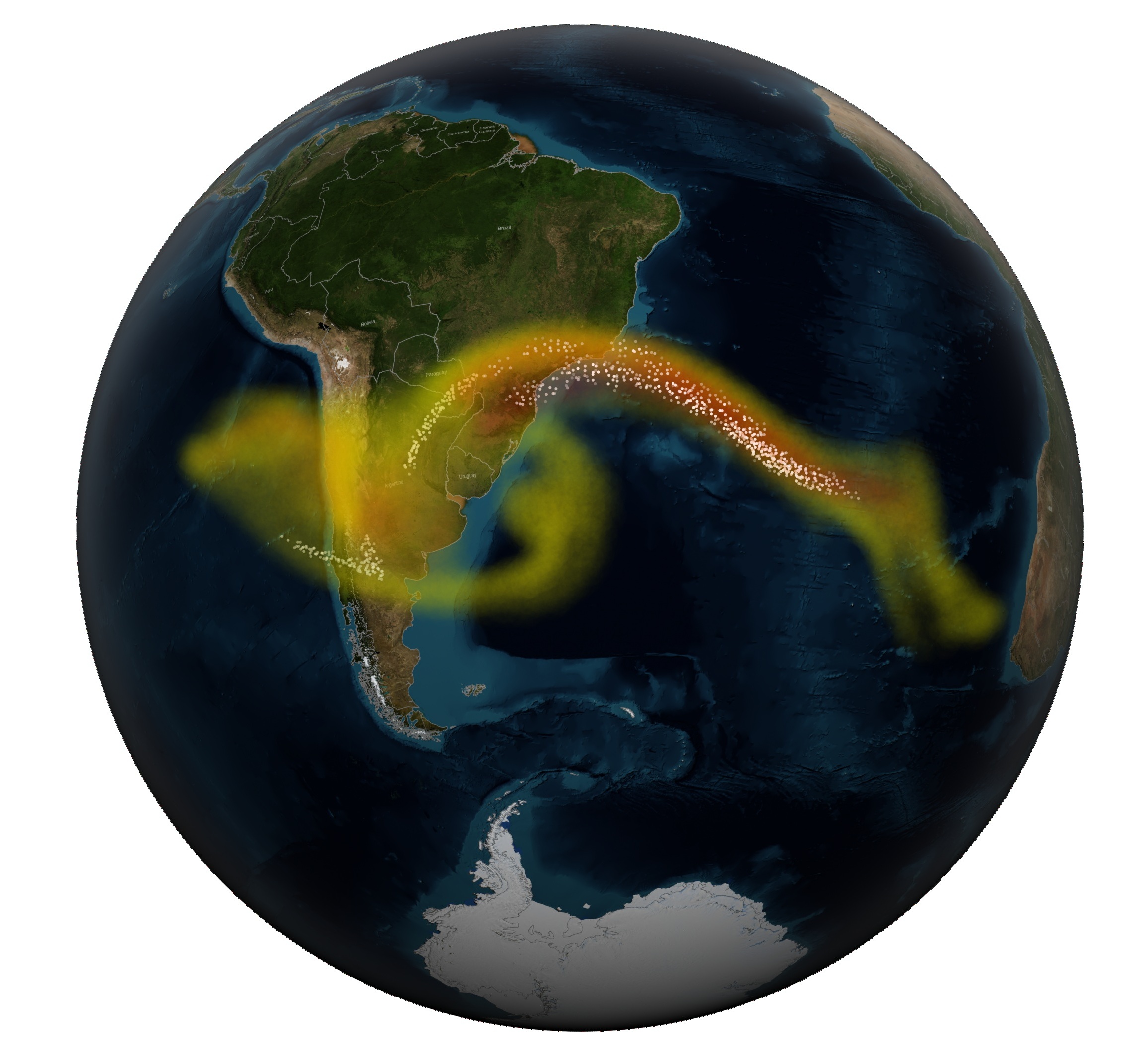
Chaitén Volcano in southern Chile erupted on May 2, 2008 for the first time in 9,000 years. NASA satellites that monitor changes in vegetation near volcanoes could aid in earlier eruption warnings.
Jeff Schmaltz, MODIS Rapid Response Team, NASA Goddard Space Flight Center
Scientists know that changing tree leaves can indicate when a nearby volcano is becoming more active and might erupt. In a new collaboration between NASA and the Smithsonian Institution, scientists now believe they can detect these changes from space.
As volcanic magma ascends through the Earth’s crust, it releases carbon dioxide and other gases which rise to the surface. Trees that take up the carbon dioxide become greener and more lush. These changes are visible in images from NASA satellites such as Landsat 8, along with airborne instruments flown as part of the Airborne Validation Unified Experiment: Land to Ocean (AVUELO).
Ten percent of the world’s population lives in areas susceptible to volcanic hazards. People who live or work within a few miles of an eruption face dangers that include ejected rock, dust, and surges of hot, toxic gases. Further away, people and property are susceptible to mudslides, ashfalls, and tsunamis that can follow volcanic blasts. There’s no way to prevent volcanic eruptions, which makes the early signs of volcanic activity crucial for public safety. According to the U.S. Geological Survey, NASA’s Landsat mission partner, the United States is one of the world’s most volcanically active countries.
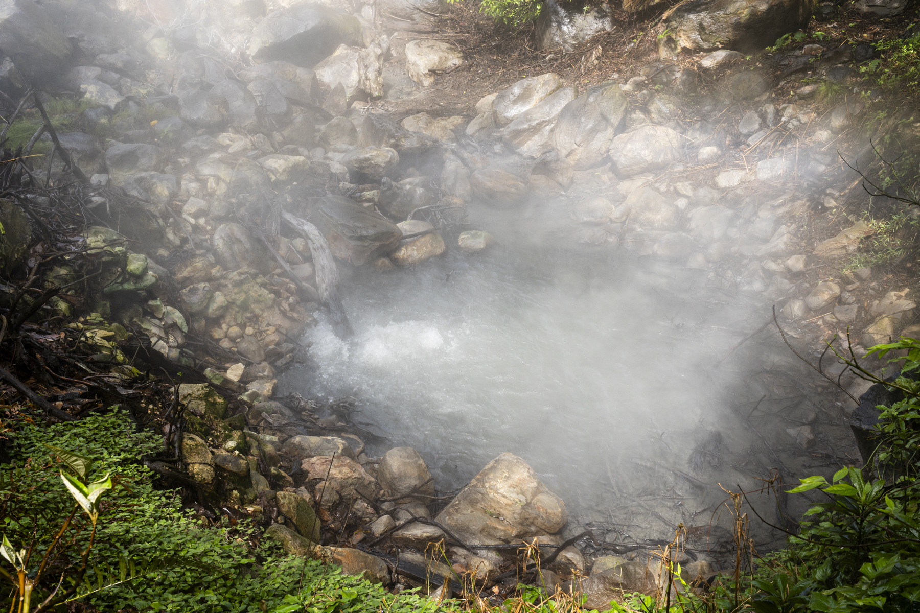
Carbon dioxide released by rising magma bubbles up and heats a pool of water in Costa Rica near the Rincón de la Vieja volcano. Increases in volcanic gases could be a sign that a volcano is becoming more active.
Alessandra Baltodano/Chapman University
When magma rises underground before an eruption, it releases gases, including carbon dioxide and sulfur dioxide. The sulfur compounds are readily detectable from orbit. But the volcanic carbon dioxide emissions that precede sulfur dioxide emissions – and provide one of the earliest indications that a volcano is no longer dormant – are difficult to distinguish from space.
The remote detection of carbon dioxide greening of vegetation potentially gives scientists another tool — along with seismic waves and changes in ground height—to get a clear idea of what’s going on underneath the volcano. “Volcano early warning systems exist,” said volcanologist Florian Schwandner, chief of the Earth Science Division at NASA’s Ames Research Center in California’s Silicon Valley, who had teamed up with climate scientist Josh Fisher of Chapman University in Orange, California and volcanologist Robert Bogue of McGill University in Montreal a decade ago. “The aim here is to make them better and make them earlier.”
“Volcanoes emit a lot of carbon dioxide,” said Bogue, but there’s so much existing carbon dioxide in the atmosphere that it’s often hard to measure the volcanic carbon dioxide specifically. While major eruptions can expel enough carbon dioxide to be measurable from space with sensors like NASA’s Orbiting Carbon Observatory 2, detecting these much fainter advanced warning signals has remained elusive. “A volcano emitting the modest amounts of carbon dioxide that might presage an eruption isn’t going to show up in satellite imagery,” he added.
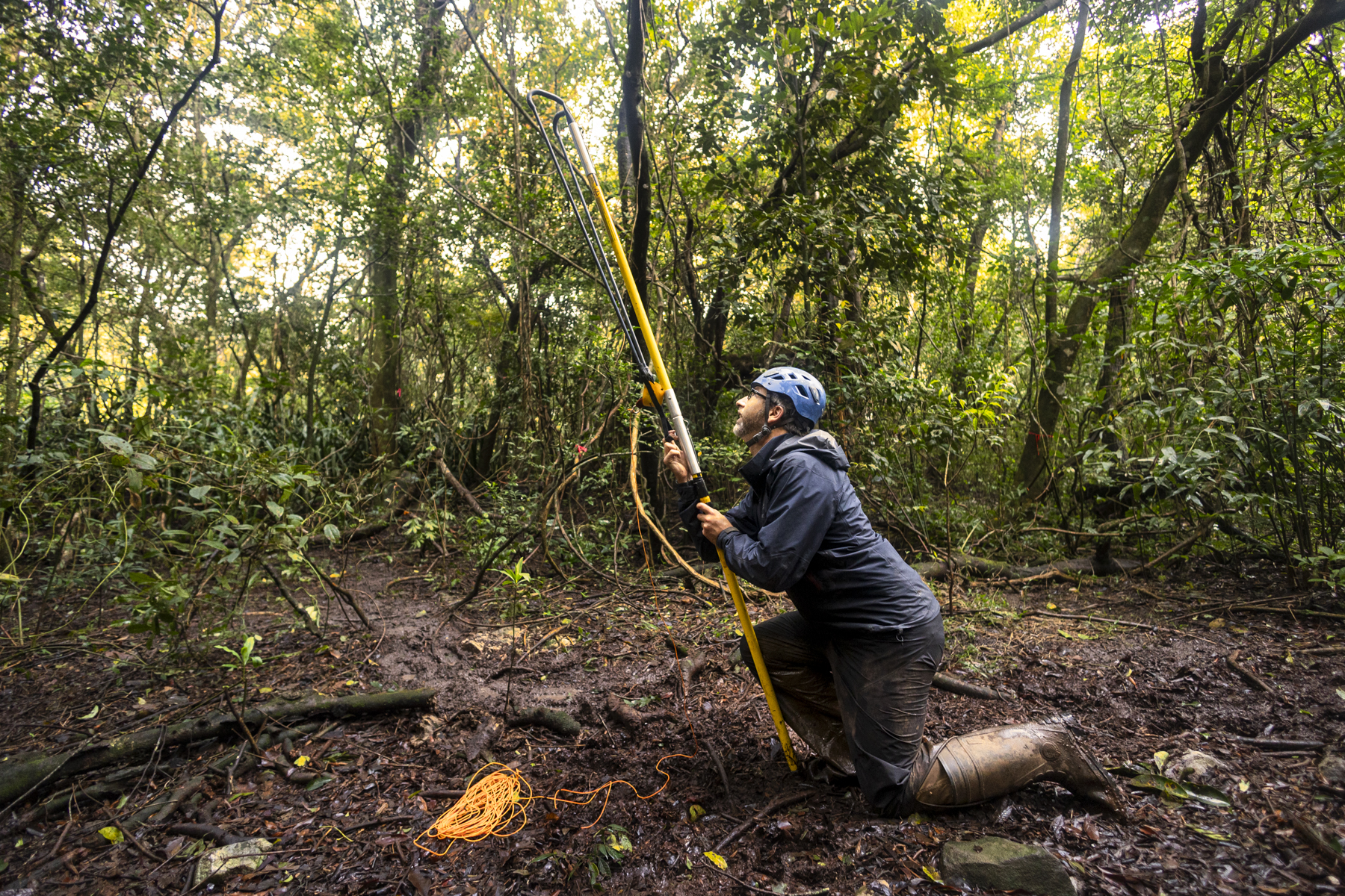
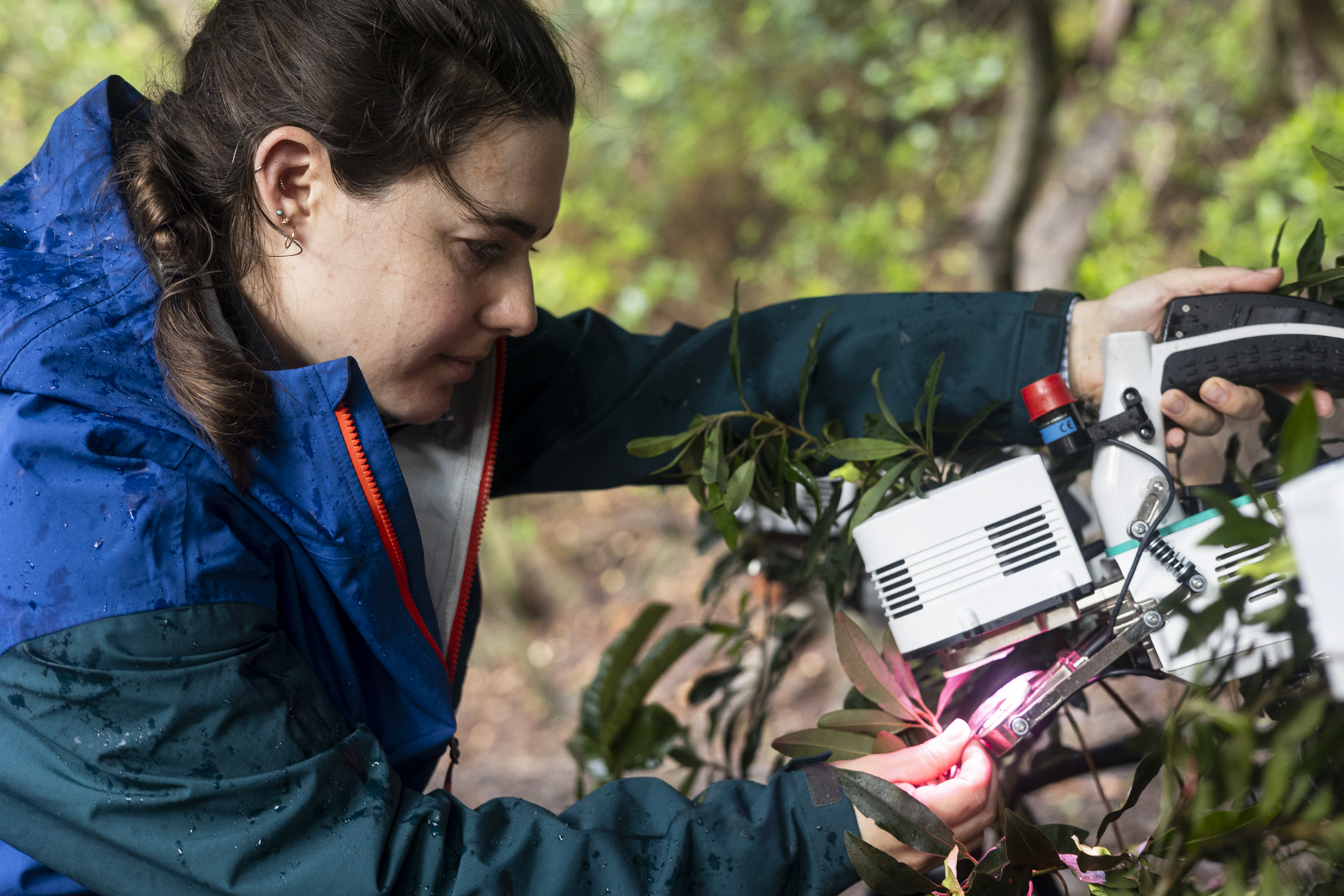
Gregory Goldsmith from Chapman University launches a slingshot into the forest canopy to install a carbon dioxide sensor in the canopy of a Costa Rican rainforest near the Rincón de la Vieja volcano.
Alessandra Baltodano/Chapman University
Because of this, scientists must trek to volcanoes to measure carbon dioxide directly. However, many of the roughly 1,350 potentially active volcanoes worldwide are in remote locations or challenging mountainous terrain. That makes monitoring carbon dioxide at these sites labor-intensive, expensive, and sometimes dangerous.
Volcanologists like Bogue have joined forces with botanists and climate scientists to look at trees to monitor volcanic activity. “The whole idea is to find something that we could measure instead of carbon dioxide directly,” Bogue said, “to give us a proxy to detect changes in volcano emissions.”
“There are plenty of satellites we can use to do this kind of analysis,” said volcanologist Nicole Guinn of the University of Houston. She has compared images collected with Landsat 8, NASA’s Terra satellite, ESA’s (European Space Agency) Sentinel-2, and other Earth-observing satellites to monitor trees around the Mount Etna volcano on the coast of Sicily. Guinn’s study is the first to show a strong correlation between tree leaf color and magma-generated carbon dioxide.
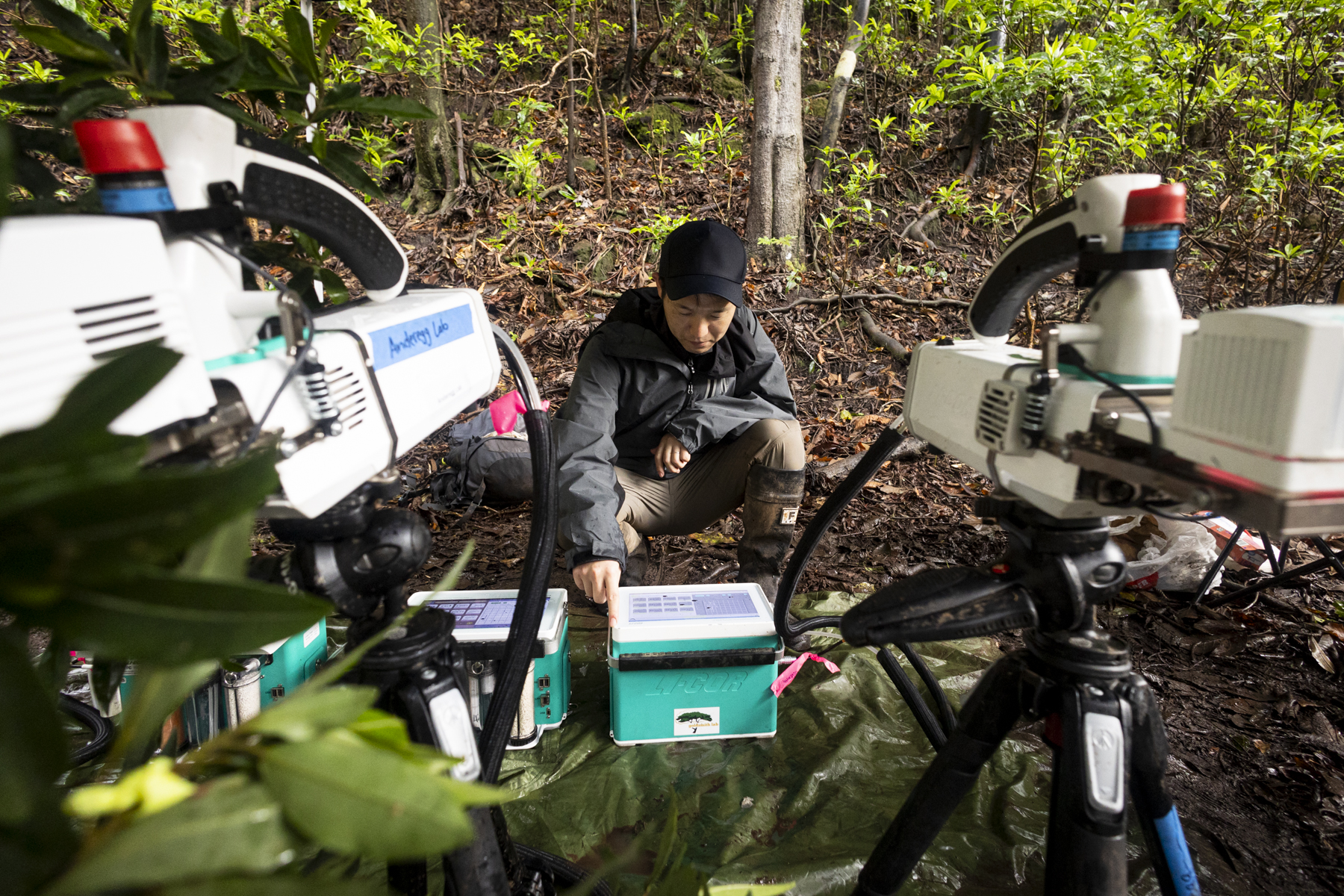
Confirming accuracy on the ground that validates the satellite imagery is a challenge that Fisher is tackling with surveys of trees around volcanoes. During the March 2025 Airborne Validation Unified Experiment: Land to Ocean mission with NASA and the Smithsonian Institution scientists deployed a spectrometer on a research plane to analyze the colors of plant life in Panama and Costa Rica.
Alexandria Pivovaroff of Occidental College measures photosynthesis in leaves extracted from trees exposed to elevated levels of carbon dioxide near a volcano in Costa Rica.
Alessandra Baltodano/Chapman University
Fisher directed a group of investigators who collected leaf samples from trees near the active Rincon de la Vieja volcano in Costa Rica while also measuring carbon dioxide levels. “Our research is a two-way interdisciplinary intersection between ecology and volcanology,” Fisher said. “We’re interested not only in tree responses to volcanic carbon dioxide as an early warning of eruption, but also in how much the trees are able to take up, as a window into the future of the Earth when all of Earth’s trees are exposed to high levels of carbon dioxide.”
Relying on trees as proxies for volcanic carbon dioxide has its limitations. Many volcanoes feature climates that don’t support enough trees for satellites to image. In some forested environments, trees respond differently to changing carbon dioxide levels. And fires, changing weather conditions, and plant diseases can complicate the interpretation of satellite data on volcanic gases.
Chapman University visiting professor Gaku Yokoyama checks on the leaf-measuring instrumentation at a field site near the Rincón de la Vieja volcano.
Alessandra Baltodano/Chapman University
Still, Schwandner has witnessed the potential benefits of volcanic carbon dioxide observations first-hand. He led a team that upgraded the monitoring network at Mayon volcano in the Philippines to include carbon dioxide and sulfur dioxide sensors. In December 2017, government researchers in the Philippines used this system to detect signs of an impending eruption and advocated for mass evacuations of the area around the volcano. Over 56,000 people were safely evacuated before a massive eruption began on January 23, 2018. As a result of the early warnings, there were no casualties.
Using satellites to monitor trees around volcanoes would give scientists earlier insights into more volcanoes and offer earlier warnings of future eruptions. “There’s not one signal from volcanoes that’s a silver bullet,” Schwandner said. “And tracking the effects of volcanic carbon dioxide on trees will not be a silver bullet. But it will be something that could change the game.”
Sasha Weston, project support, Small Spacecraft and Distributed Systems program, with the Project and Engineering Support Services II contract with NASA, discusses the program with a participant, right, during Ames Partnership Days on April 29, 2025, at NASA’s Ames Research Center in California’s Silicon Valley. Through partnerships, the program advances technologies that enable small spacecraft to achieve NASA missions in faster and more affordable ways.
NASA/Brandon Torres Navarrete
On April 29, more than 90 representatives from industry, U.S. federal labs, government agencies, and academia gathered at NASA’s Ames Research Center in California’s Silicon Valley to learn about the center’s groundbreaking research and development capabilities. The three-day event provided insight into the many ways to collaborate with NASA, including tapping into the agency’s singular subject matter expertise and gaining access to state-of-the-art facilities at NASA Ames and centers across the country. Partnerships help the agency to advance technological innovation, enable science, and foster the emerging space economy.
Terry Fong, senior scientist for autonomous systems at NASA Ames, summed up the objective of the event when he noted, “I don’t believe anyone – government, academia, industry – has a monopoly on good ideas. It’s how you best combine forces to have the greatest effect.”
Terry Fong, senior scientist at NASA Ames, center, discusses the center’s capabilities in intelligent adaptive systems and potential applications with Jessica Nowinski, chief of the Human Systems Integration division, left, and Alonso Vera, senior technologist, right, on April 29, 2025, at NASA’s Ames Research Center in California’s Silicon Valley.
A Volvo Crawler Excavator severs the airframe, separating the tail section from the fuselage, of the modified C-141 Kuiper Airborne Observatory at Moffett Field, California.
NASA
The planned deconstruction, disposal, and preservation of historic parts of NASA’s decommissioned Kuiper Airborne Observatory is complete. Part of the airborne astronomy legacy of NASA’s Ames Research Center in California’s Silicon Valley, Kuiper conducted more than two decades of astronomical observations from 1975 to 1995. Later this year, the Kuiper cockpit will go on display at the Pima Air & Space Museum in Pima, Arizona, where NASA’s retired SOFIA (Stratospheric Observatory for Infrared Astronomy) aircraft is located, while its telescope will go on display at the Moffett Field Museum in the NASA Research Park.
What does the future of space exploration look like? At the 2025 FIRST Robotics World Championship in Houston, NASA gave student robotics teams and industry leaders a first-hand look—complete with lunar rovers, robotic arms, and real conversations about shaping the next era of discovery.
Students and mentors experience NASA exhibits at the 2025 FIRST Robotics World Championship at the George R. Brown Convention Center in Houston from April 16-18.
NASA/Sumer Loggins
NASA engaged directly with the Artemis Generation, connecting with more than 55,000 students and 75,000 parents and mentors. Through interactive exhibits and discussions, students explored the agency’s robotic technologies, learned about STEM career paths and internships, and gained insight into NASA’s bold vision for the future. Many expressed interest in internships—and dreams of one day contributing to NASA’s missions to explore the unknown for the benefit of all humanity.
Multiple NASA centers participated in the event, including Johnson Space Center in Houston; Jet Propulsion Laboratory in Southern California; Kennedy Space Center in Florida; Langley Research Center in Virginia; Ames Research Center in California; Michoud Assembly Facility in New Orleans; Armstrong Flight Research Center in Edwards, California; Glenn Research Center in Cleveland; Goddard Space Flight Center in Greenbelt, Maryland; and the Katherine Johnson Independent Verification and Validation Facility in West Virginia. Each brought unique technologies and expertise to the exhibit floor.
FIRST Robotics attendees explore NASA’s exhibit and learn about the agency’s mission during the event.
Space Exploration Vehicle: A pressurized rover prototype built for human exploration of planetary surfaces, offering attendees a look at how future astronauts may one day travel across the Moon or Mars.
Mars Perseverance Rover: An exhibit detailing the rover’s mission to search for ancient microbial life and collect samples for future return to Earth.
In-Situ Resource Utilization Pilot Excavator: A lunar bulldozer-dump truck hybrid designed to mine and transport regolith, supporting long-term exploration through the Artemis campaign.
Visitors view NASA’s Space Exploration Vehicle on display.
NASA/Robert Markowitz
“These demonstrations help students see themselves in NASA’s mission and the next frontier of lunar exploration,” said Johnson Public Affairs Specialist Andrew Knotts. “They can picture their future as part of the team shaping how we live and work in space.”
Since the FIRST Championship relocated to Houston in 2017, NASA has mentored more than 250 robotics teams annually, supporting elementary through high school students. The agency continued that tradition for this year’s event, and celebrated the fusion of science, engineering, and creativity that defines both robotics and space exploration.
NASA’s booth draws crowds at FIRST Robotics 2025 with hands-on exhibits.
NASA/Robert Markowitz
Local students also had the chance to learn about the Texas High School Aerospace Scholars program, which offers Texas high school juniors hands-on experience designing space missions and solving engineering challenges—an early gateway into NASA’s world of exploration.
As the competition came to a close, students and mentors were already looking ahead to the next season—energized by new ideas, strengthened friendships, and dreams of future missions.
NASA volunteers at the FIRST Robotics World Championship on April 17, 2025.
NASA/Robert Markowitz
“It was a true privilege to represent NASA to so many inspiring students, educators, and mentors,” said Jeanette Snyder, aerospace systems engineer for Gateway. “Not too long ago, I was a robotics student myself, and I still use skills I developed through FIRST Robotics in my work as a NASA engineer. Seeing so much excitement around engineering and technology makes me optimistic for the future of space exploration. I can’t wait to see these students become the next generation of NASA engineers and world changers.”
With the enthusiastic support of volunteers, mentors, sponsors, and industry leaders, and NASA’s continued commitment to STEM outreach, the future of exploration is in bold, capable hands.
See the full event come to life in the panorama videos below.
Preparations for Next Moonwalk Simulations Underway (and Underwater)
Nemanja Jovanovic, lead instrument scientist at Caltech, presents at the Emerging Technologies for Astrophysics workshop, held at NASA’s Ames Research Center in California’s Silicon Valley. The workshop brought together experts in astrophysics to discuss how advanced technologies could impact future mission planning.
NASA/Donald Richey
The future of astrophysics research could unlock the secrets of the universe, and emerging technologies like artificial intelligence, quantum sensing, and advanced materials may hold the key to faster, more efficient discovery. Advancements and implementations of new technologies are imperative for observational astrophysics to achieve the next level of detection.
NASA’s Emerging Technologies for Astrophysics workshop brought together subject matter experts from industry, government, and academia to explore the state of new and disruptive technologies. The meeting was an effort to identify specific applications for astrophysics missions and better understand how their infusion into future NASA space telescopes could be accelerated.
The workshop took place at NASA’s Ames Research Center in California’s Silicon Valley,. supporting the agency’s efforts to make partnership with public and private industry and collaborative mission planning possible.
“The profound questions about the nature of our universe that astrophysics at NASA answers require giant leaps in technology,” explained Mario Perez, chief technologist for the Astrophysics Division at NASA Headquarters in Washington. “Spotting potential in early-stage tech by encouraging discussions between imaginative researchers helps expand the scope of science and lessen the time required to achieve the next generation of astrophysics missions.”
Emerging technologies like artificial intelligence can support the design and optimization of future missions, and participants focused efforts on combining technologies to push research further. “Cross-pollination” of advanced materials like composites with advanced manufacturing, metamaterials, and photonic chips could support advancement in imaging missions beyond existing mechanical stability needs.
The United Nations Educational, Scientific and Cultural Organization (UNESCO) has dubbed 2025 the “International Year of Quantum Science and Technology” in recognition of a century of quantum mechanics. Workshop participants discussed how quantum sensing could enable more precise measurements, achieve “super resolution” by filling in missing details in lower resolution images, and provide greater capabilities in forthcoming space telescopes.
“This gathering of experts was an opportunity to find ways where we can increase the capabilities of future space instrumentation and accelerate technology development for infusion into NASA astrophysics missions,” said Naseem Rangwala, astrophysics branch chief at NASA Ames. “We can speed up the process of how we develop these future projects by using the emerging technologies that are incubated right here in Silicon Valley.”
The findings from this workshop and ongoing discussions will support efforts to study and invest in technologies to advance astrophysics missions with greater speed and efficiency.
Preparations for Next Moonwalk Simulations Underway (and Underwater)
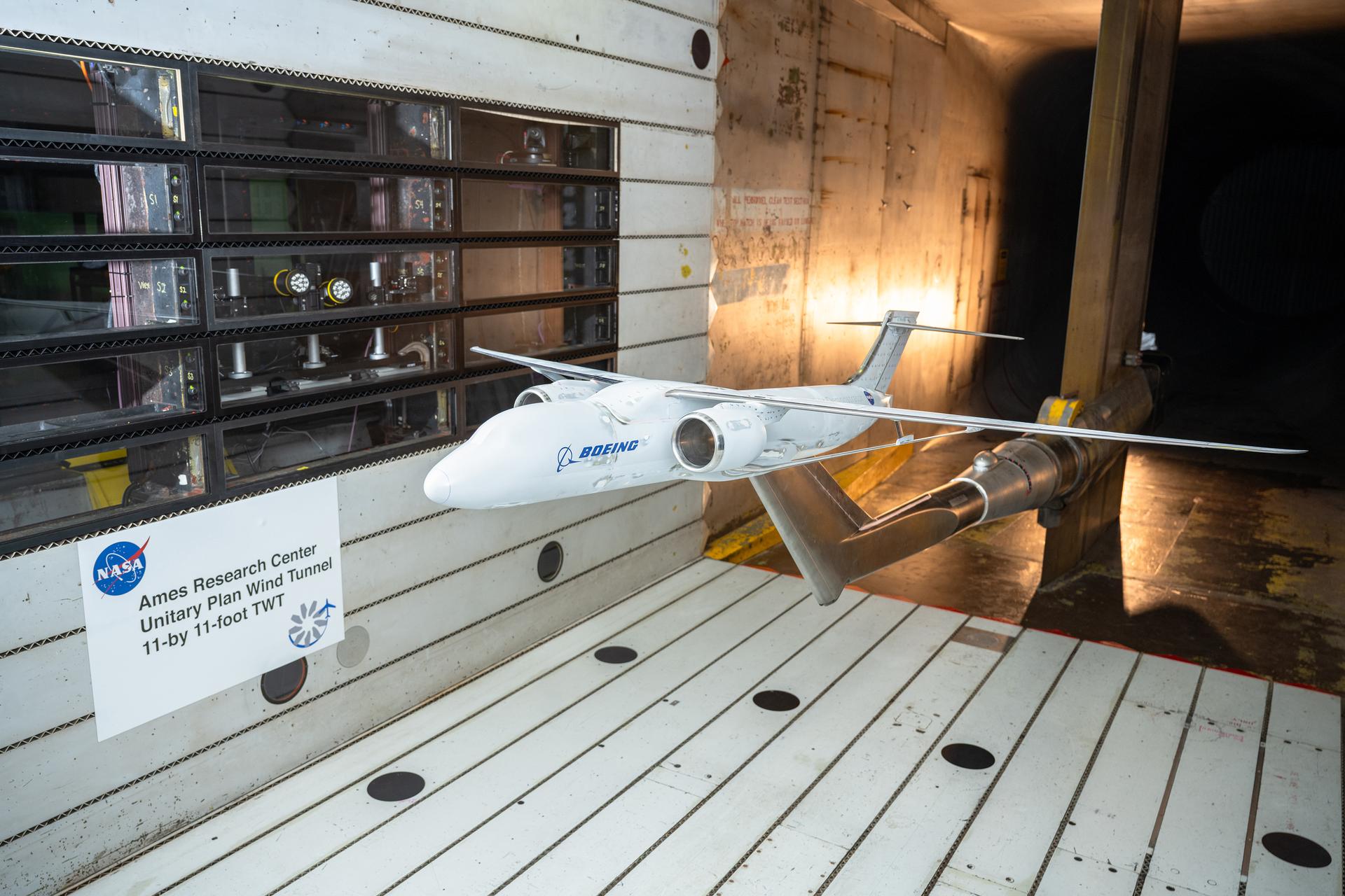
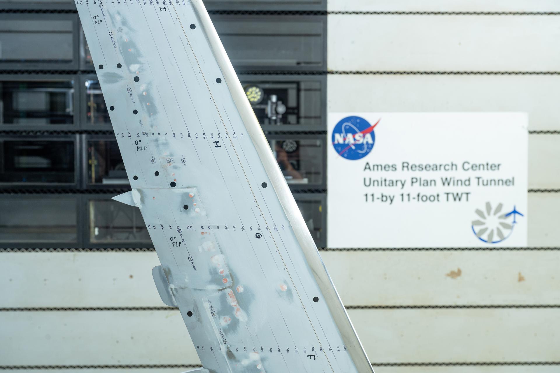
A Boeing-built X-66 full-span model underwent testing in the 11-Foot Transonic Unitary Plan Facility at NASA’s Ames Research Center in California’s Silicon Valley between January and March 2025.
NASA / Brandon Torres
NASA and Boeing are currently evaluating an updated approach to the agency’s Sustainable Flight Demonstrator project that would focus on demonstrating thin-wing technology with broad applications for multiple aircraft configurations.
Boeing’s proposed focus centers on a ground-based testbed to demonstrate the potential for long, thin-wing technology. Work on the X-66 flight demonstrator – which currently incorporates a more complex transonic truss braced wing concept that uses the same thin wing technology as well as aerodynamic, structural braces — would pause for later consideration based on the thin-wing testbed results and further truss-braced configuration studies.
Under this proposal, all aspects of the X-66 flight demonstrator’s design, as well as hardware acquired or modified for it, would be retained while the long, thin-wing technology is being investigated with more focus. NASA and Boeing would also continue to collaborate on research into the transonic truss-braced wing concept.
The proposal is based on knowledge gained through research conducted under the Sustainable Flight Demonstrator project so far.
Since NASA issued the Sustainable Flight Demonstrator award in 2023, the project has made significant progress toward its goal of informing future generations of more sustainable commercial airliners. Boeing and NASA have collaborated on wind tunnel tests, computational fluid dynamics modeling, and structural design and analysis aimed at exploring how best to approach fuel-efficient, sustainable designs.
This research has built confidence in the substantial potential energy-savings benefits that technologies investigated through the Sustainable Flight Demonstrator project and other NASA research can make possible. The Boeing proposal identifies the thin-wing concept as having broad applications for potential incorporation into aircraft with and without truss braces.
NASA and Boeing are discussing potential options for advancing these sustainable flight technologies. NASA’s ultimate goal for this sustainable aircraft research is to achieve substantial improvements for next-generation airliner efficiency, lower costs for travelers, reduced fuel costs and consumption, and increase U.S. aviation’s technological leadership.
Preparations for Next Moonwalk Simulations Underway (and Underwater)
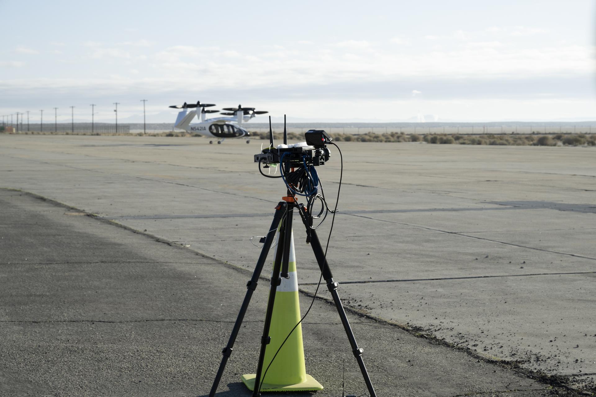
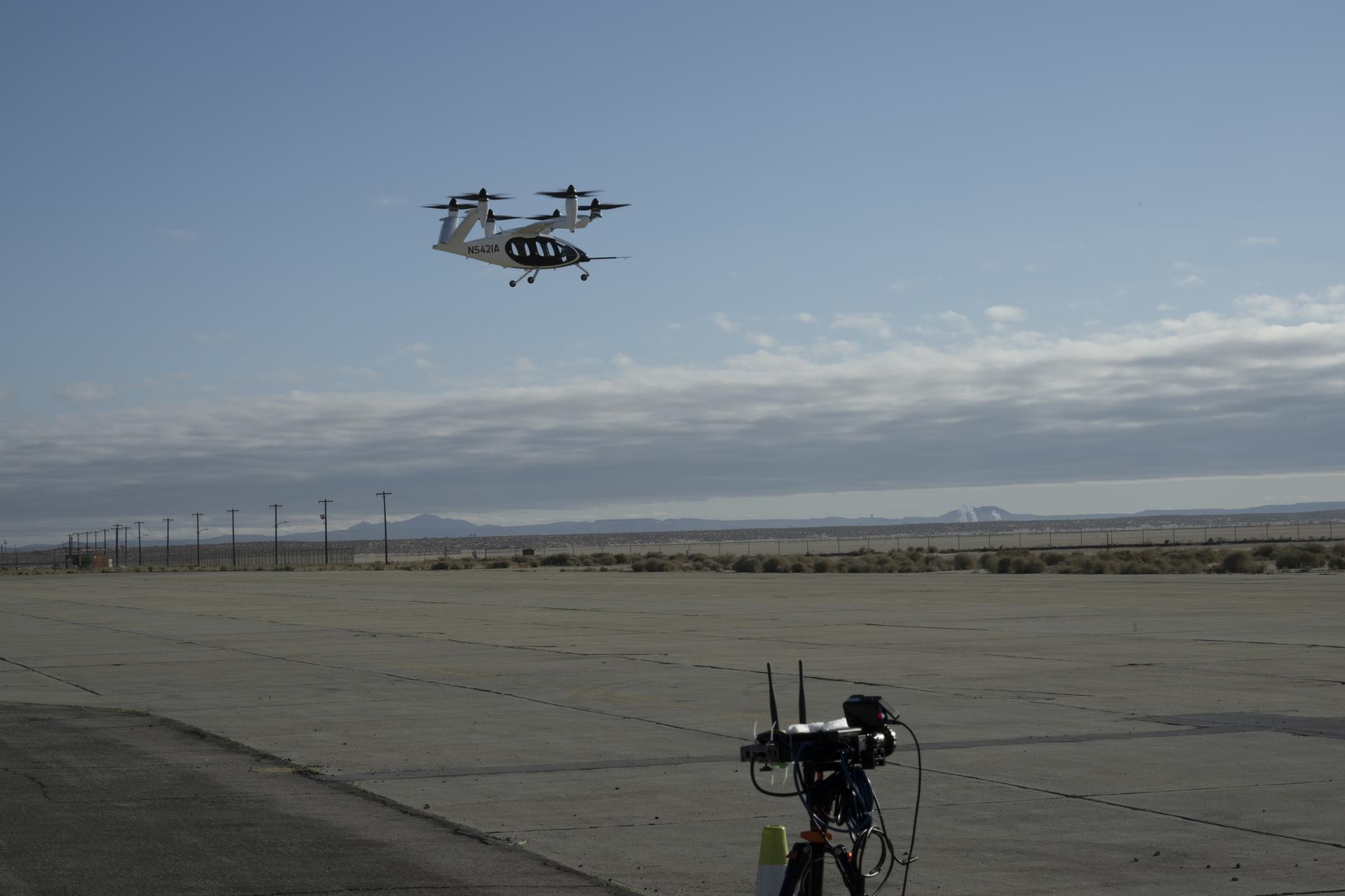
One of several NASA distributed sensing ground nodes is set up in the foreground while an experimental air taxi aircraft owned by Joby Aviation sits in the background near NASA’s Armstrong Flight Research Center in Edwards, California, on March 12, 2025. NASA is collecting information during this study to help advance future air taxi flights, especially those occurring in cities, to track aircraft moving through traffic corridors and around landing zones.
NASA/Genaro Vavuris
NASA engineers began using a network of ground sensors in March to collect data from an experimental air taxi to evaluate how to safely integrate such vehicles into airspace above cities – in all kinds of weather.
Researchers will use the campaign to help improve tools to assist with collision avoidance and landing operations and ensure safe and efficient air taxi operations in various weather conditions.
For years, NASA has looked at how wind shaped by terrain, including buildings in urban areas, can affect new types of aircraft. The latest test, which is gathering data from a Joby Aviation demonstrator aircraft, looks at another kind of wind – that which is generated by the aircraft themselves.
Joby flew its air taxi demonstrator over NASA’s ground sensor array near the agency’s Armstrong Flight Research Center in Edwards, California producing air flow data. The Joby aircraft has six rotors that allow for vertical takeoffs and landings, and tilt to provide lift in flight. Researchers focused on the air pushed by the propellers, which rolls into turbulent, circular patterns of wind.
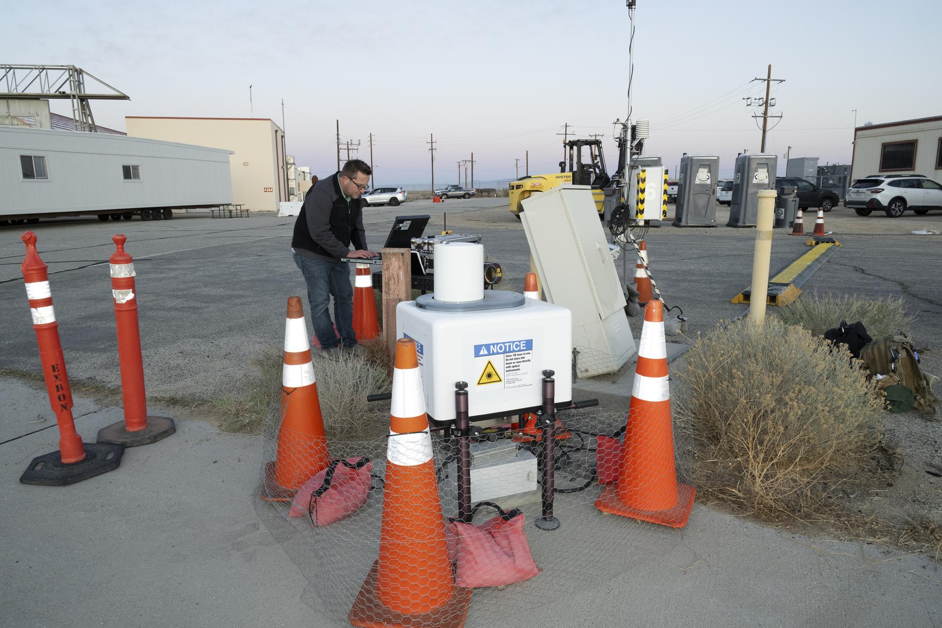
NASA aeronautical meteorologist Luke Bard adjusts one of several wind lidar (light detection and ranging) sensors near NASA’s Armstrong Flight Research Center in Edwards, California, on March 12, 2025, in preparation to collect data from Joby Aviation’s experimental air taxi aircraft. NASA is collecting information during this study to help advance weather-tolerant air taxi operations for the entire industry
NASA/Genaro Vavuris
This rolling wind can affect the aircraft’s performance, especially when it’s close to the ground, as well as others flying in the vicinity and people on the ground. Such wind turbulence is difficult to measure, so NASA enhanced its sensors with a new type of lidar – a system that uses lasers to measure precise distances – and that can map out the shapes of wind features.
“The design of this new type of aircraft, paired with the NASA lidar technology during this study, warrants a better understanding of possible wind and turbulence effects that can influence safe and efficient flights,” said Grady Koch, lead for this research effort, from NASA’s Langley Research Center in Hampton, Virginia.
Data to Improve Aircraft Tracking
NASA also set up a second array of ground nodes including radar, cameras, and microphones in the same location as the sensors to provide additional data on the aircraft. These nodes will collect tracking data during routine flights for several months.
The agency will use the data gathered from these ground nodes to demonstrate the tracking capabilities and functions of its “distributed sensing” technology, which involves embedding multiple sensors in an area where aircraft are operating.
One of multiple NASA distributed sensing ground nodes is set up in the foreground while an experimental air taxi aircraft owned by Joby Aviation hovers in the background near NASA’s Armstrong Flight Research Center in Edwards, California, on March 12, 2025. NASA is collecting information during this study to help advance future air taxi flights, especially those occurring in cities, to track aircraft moving through traffic corridors and around landing zones.
NASA/Genaro Vavuris
This technology will be important for future air taxi flights, especially those occurring in cities by tracking aircraft moving through traffic corridors and around landing zones. Distributed sensing has the potential to enhance collision avoidance systems, air traffic management, ground-based landing sensors, and more.
“Our early work on a distributed network of sensors, and through this study, gives us the opportunity to test new technologies that can someday assist in airspace monitoring and collision avoidance above cities,” said George Gorospe, lead for this effort from NASA’s Ames Research Center in California’s Silicon Valley.
Using this data from an experimental air taxi aircraft, NASA will further develop the technology needed to help create safer air taxi flights in high-traffic areas. Both of these efforts will benefit the companies working to bring air taxis and drones safely into the airspace.
NASA Tests Drones to Provide Micrometeorology, Aid in Fire Response
Pilot in command Brayden Chamberlain performs pre-flight checks on the NASA Alta X quadcopter during the FireSense uncrewed aerial system (UAS) technology demonstration in Missoula.
Credits: NASA ARC/Milan Loiacono
In Aug. 2024, a team of NASA researchers and partners gathered in Missoula, Montana to test new drone-based technology for localized forecasting, or micrometeorology. Researchers attached wind sensors to a drone, NASA’s Alta X quadcopter, aiming to provide precise and sustainable meteorological data to help predict fire behavior.
Wildfires are increasing in number and severity around the world, including the United States, and wind is a major factor. It leads to unexpected and unpredictable fire growth, public threats, and fire fatalities, making micrometeorology a very effective tool to combat fire.
This composite image shows the NASA Alta X quadcopter taking off during one of eight flights it performed for the 2024 FireSense UAS technology demonstration in Missoula. Mounted on top of the drone is a unique infrastructure designed at NASA’s Langley Research Center in Hampton,Virginia, to carry sensors that measure wind speed and direction into the sky. On the ground, UAS pilot in command Brayden Chamberlain performs final pre-flight checks.
NASA/Milan Loiacono
The campaign was run by NASA’s FireSense project, focused on addressing challenges in wildland fire management by putting NASA science and technology in the hands of operational agencies.
“Ensuring that the new technology will be easily adoptable by operational agencies such as the U.S. Forest Service and the National Weather Service was another primary goal of the campaign,” said Jacquelyn Shuman, FireSense project scientist at NASA’s Ames Research Center in California’s Silicon Valley.
The FireSense team chose the Alta X drone because the U.S. Forest Service already has a fleet of the quadcopters and trained drone pilots, which could make integrating the needed sensors – and the accompanying infrastructure – much easier and more cost-effective for the agency.
The UAS pilot in command, Brayden Chamberlain, flashes a “good to go” signal to the command tent, indicating that the NASA Alta X quadcopter is prepped for takeoff. Behind Chamberlain, the custom structure attached to the quadcopter holds a radiosonde (small white box) and an anemometer (hidden from view), which will collect data on wind speed and direction, humidity, temperature, and pressure.
NASA/Milan Loiacono
The choice of the two sensors for the drone’s payload was also driven by their adoptability.
The first, called a radiosonde, measures wind direction and speed, humidity, temperature, and pressure, and is used daily by the National Weather Service. The other sensor, an anemometer, measures wind speed and direction, and is used at weather stations and airports around the world.
The two sensors mounted on the NASA Alta X quadcopter are a radiosonde (left) and an anemometer (right), which measure wind speed and direction. The FireSense teams hopes that by giving them wings, researchers can enable micrometeorology to better predict fire and smoke behavior.
NASA/Milan Loiacono
“Anemometers are everywhere, but are usually stationary,” said Robert McSwain, the FireSense uncrewed aerial system (UAS) lead, based at NASA’s Langley Research Center in Hampton, Virginia. “We are taking a sensor type that is already used all over the world, and giving it wings.”
Anemometers are everywhere, but are usually stationary. We are taking a sensor type that is already used all over the world, and giving it wings.
Robert Mcswain
FireSense Uncrewed Aerial System (UAS) Lead
Both sensors create datasets that are already familiar to meteorologists worldwide, which opens up the potential applications of the platform.
Current Forecasting Methods: Weather Balloons
Traditionally, global weather forecasting data is gathered by attaching a radiosonde to a weather balloon and releasing it into the air. This system works well for regional weather forecasts. But the rapidly changing environment of wildland fire requires more recurrent, pinpointed forecasts to accurately predict fire behavior. It’s the perfect niche for a drone.
Left: Steven Stratham (right) attaches a radiosonde to the string of a weather balloon as teammates Travis Christopher (left) and Danny Johnson (center) prepare the balloon for launch. This team of three from Salish Kootenai College is one of many college teams across the nation trained to prepare and launch weather balloons. Right: One of these weather balloons lifts into the sky, with the radiosonde visible at the end of the string.
NASA/Milan Loiacono
“These drones are not meant to replace the weather balloons,” said Jennifer Fowler, FireSense’s project manager at Langley. “The goal is to create a drop-in solution to get more frequent, localized data for wildfires – not to replace all weather forecasting.”
The goal is to create a drop-in solution to get more frequent, localized data for wildfires – not to replace all weather forecasting.
Jennifer Fowler
FireSense Project Manager
Drones Provide Control, Repeat Testing, Sustainability
Drones can be piloted to keep making measurements over a precise location – an on-site forecaster could fly one every couple of hours as conditions change – and gather timely data to help determine how weather will impact the direction and speed of a fire.
Fire crews on the ground may need this information to make quick decisions about where to deploy firefighters and resources, draw fire lines, and protect nearby communities.
A reusable platform, like a drone, also reduces the financial and environmental impact of forecasting flights.
“A weather balloon is going to be a one-off, and the attached sensor won’t be recovered,” Fowler said. “The instrumented drone, on the other hand, can be flown repeatedly.”
The NASA Alta X quadcopter sits in a field in Missoula, outfitted with a special structure to carry a radiosonde (sensor on the left) and an anemometer (sensor on the right) into the air. This structure was engineered at NASA’s Langley Research Center to ensure the sensors are far enough from the rotors to avoid interfering with the data collected, but without compromising the stability of the drone.
NASA/Milan Loiacono
The Missoula Campaign
Before such technology can be sent out to a fire, it needs to be tested. That’s what the FireSense team did this summer.
Smoke from the nearby Miller Peak Fire drifts by the air control tower at Missoula Airport on August 29, 2024. Miller Peak was one of several fires burning in and around Missoula that month, creating a smokey environment which, combined with the mountainous terrain, made the area an ideal location to test FireSense’s new micrometeorology technology.
NASA/Milan Loiacono
McSwain described the conditions in Missoula as an “alignment of stars” for the research: the complex mountain terrain produces erratic, historically unpredictable winds, and the sparsity of monitoring instruments on the ground makes weather forecasting very difficult. During the three-day campaign, several fires burned nearby, which allowed researchers to test how the drones performed in smokey conditions.
A drone team out of NASA Langley conducted eight data-collection flights in Missoula. Before each drone flight, student teams from the University of Idaho in Moscow, Idaho, and Salish Kootenai College in Pablo, Montana, launched a weather balloon carrying the same type of radiometer.
Left: Weather balloon teams from University of Idaho and Salish Kootenai College prepare a weather balloon for launch on the second day of the FireSense campaign in Missoula. Right: NASA Langley drone crew members Todd Ferrante (left) and Brayden Chamberlain (right) calibrate the internal sensors of the NASA Alta X quadcopter before its first test flight on Aug. 27, 2024.
Once those data sets were created, they needed to be transformed into a usable format. Meteorologists are used to the numbers, but incident commanders on an active fire need to see the data in a form that allows them to quickly understand which conditions are changing, and how. That’s where data visualization partners come in. For the Missoula campaign, teams from MITRE, NVIDIA, and Esri joined NASA in the field.
An early data visualization from the Esri team shows the flight paths of weather balloons launched on the first day of the FireSense UAS technology demonstration in Missoula. The paths are color-coded by wind speed, from purple (low wind) to bright yellow (high wind).
NASA/Milan Loiacono
Measurements from both the balloon and the drone platforms were immediately sent to the on-site data teams. The MITRE team, together with NVIDIA, tested high-resolution artificial intelligence meteorological models, while the Esri team created comprehensive visualizations of flight paths, temperatures, and wind speed and direction. These visual representations of the data make conclusions more immediately apparent to non-meteorologists.
What’s Next?
Development of drone capabilities for fire monitoring didn’t begin in Missoula, and it won’t end there.
“This campaign leveraged almost a decade of research, development, engineering, and testing,” said McSwain. “We have built up a UAS flight capability that can now be used across NASA.”
This campaign leveraged almost a decade of research, development, engineering, and testing. We have built up a UAS flight capability that can now be used across NASA.
Robert Mcswain
FireSense Uncrewed Aerial System (UAS) Lead
The NASA Alta X and its sensor payload will head to Alabama and Florida in spring 2025, incorporating improvements identified in Montana. There, the team will perform another technology demonstration with wildland fire managers from a different region.
The FireSense project is led by NASA Headquarters in Washington and sits within the Wildland Fires program, with the project office based at NASA Ames. The goal of FireSense is to transition Earth science and technological capabilities to operational wildland fire management agencies, to address challenges in U.S. wildland fire management before, during, and after a fire.
About the Author
Milan Loiacono
Science Communication Specialist
Milan Loiacono is a science communication specialist for the Earth Science Division at NASA Ames Research Center.
NASA’s Ames Research Center in Silicon Valley invites media to learn more about Distributed Spacecraft Autonomy (DSA), a technology that allows individual spacecraft to make independent decisions while collaborating with each other to achieve common goals – without human input. The DSA team achieved multiple firsts during tests of such swarm technology as part of the agency’s project.
DSA develops software tools critical for future autonomous, distributed, and intelligent spacecraft that will need to interact with each other to achieve complex mission objectives. Testing onboard the agency’s Starling mission resulted in accomplishments including the first fully distributed autonomous operation of multiple spacecraft, the first use of space-to-space communications to autonomously share status information between multiple spacecraft, and more.
DSA’s accomplishments mark a significant milestone in advancing autonomous systems that will make new types of science and exploration possible.
Caleb Adams, DSA project manager, is available for interview on Wednesday, Feb. 5 and Thursday, Feb. 6. To request an interview, media can contact the Ames Office of Communications by email at arc-dl-newsroom@nasa.gov or by phone at 650-604-4789.
Learn more about NASA Ames’ world-class research and development in aeronautics, science, and exploration technology at:
To receive local NASA Ames news, email local-reporters-request@lists.arc.nasa.gov with “subscribe” in the subject line. To unsubscribe, email the same address with “unsubscribe” in the subject line.
Preparations for Next Moonwalk Simulations Underway (and Underwater)
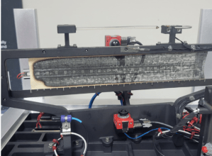
NASA’s Sustainable Flight Demonstrator project concluded wind tunnel testing in the fall of 2024. Tests on a Boeing-built X-66 model were completed at NASA’s Ames Research Center in California’s Silicon Valley in its 11-Foot Transonic Unitary Plan Facility. The model underwent tests representing expected flight conditions to obtain engineering information to influence design of the wing and provide data for flight simulators.
NASA/Brandon Torres Navarrete
NASA’s Sustainable Flight Demonstrator (SFD) project recently concluded wind tunnel tests of its X-66 semi-span model in partnership with Boeing. The model, designed to represent half the aircraft, allows the research team to generate high-quality data about the aerodynamic forces that would affect the actual X-66.
Test results will help researchers identify areas where they can refine the X-66 design – potentially reducing drag, enhancing fuel efficiency, or adjusting the vehicle shape for better flying qualities.
Tests on the Boeing-built X-66 semi-span model were completed at NASA’s Ames Research Center in California’s Silicon Valley in its 11-Foot Transonic Unitary Plan Facility. The model underwent tests representing expected flight conditions so the team could obtain engineering information to influence the design of the aircraft’s wing and provide data for flight simulators.
NASA’s Sustainable Flight Demonstrator project concluded wind tunnel testing in the fall of 2024. Tests on a Boeing-built X-66 model were completed at NASA’s Ames Research Center in California’s Silicon Valley in its 11-Foot Transonic Unitary Plan Facility. Pressure points, which are drilled holes with data sensors attached, are installed along the edge of the wing and allow engineers to understand the characteristics of airflow and will influence the final design of the wing.
NASA/Brandon Torres Navarrete
Semi-span tests take advantage of symmetry. The forces and behaviors on a model of half an aircraft mirror those on the other half. By using a larger half of the model, engineers increase the number of surface pressure measurements. Various sensors were placed on the wing to measure forces and movements to calculate lift, drag, stability, and other important characteristics.
The semi-span tests follow earlier wind tunnel work at NASA’s Langley Research Center in Hampton, Virginia, using a smaller model of the entire aircraft. Engineers will study the data from all of the X-66 wind tunnel tests to determine any design changes that should be made before fabrication begins on the wing that will be used on the X-66 itself.
The SFD project is NASA’s effort to develop more efficient aircraft configurations as the nation moves toward aviation that’s more economically, societally, and environmentally sustainable. The project seeks to provide information to inform the next generation of single-aisle airliners, the most common aircraft in commercial aviation fleets around the world. Boeing and NASA are partnering to develop the X-66 experimental demonstrator aircraft.
Preparations for Next Moonwalk Simulations Underway (and Underwater)
An FVR90 unmanned aerial vehicle (UAV) lifts off from the Monterey Bay Academy Airport near Watsonville, California, during the Advanced Capabilities for Emergency Response Operations (ACERO) Shakedown Test in November 2024.
NASA/Don Richey
NASA is collaborating with the wildland fire community to provide tools for some of the most challenging aspects of firefighting – particularly aerial nighttime operations.
In the future, agencies could more efficiently use drones, both remotely piloted and fully autonomous, to help fight wildfires. NASA recently tested technologies with teams across the country that will enable aircraft – including small drones and helicopters outfitted with autonomous technology for remote piloting – to monitor and fight wildfires 24 hours a day, even during low-visibility conditions.
Current aerial firefighting operations are limited to times when aircraft have clear visibility – otherwise, pilots run the risk of flying into terrain or colliding with other aircraft. NASA-developed airspace management technology will enable drones and remotely piloted aircraft to operate at night, expanding the window of time responders have to aerially suppress fires.
“We’re aiming to provide new tools – including airspace management technologies – for 24-hour drone operations for wildfire response,” said Min Xue, project manager of the Advanced Capabilities for Emergency Response Operations (ACERO) project within NASA’s Aeronautics Research Mission Directorate. “This testing will provide valuable data to inform how we mature this technology for eventual use in the field.”
Over the past year, ACERO researchers developed a portable airspace management system (PAMS) drone pilots can use to safely send aircraft into wildfire response operations when operating drones from remote control systems or ground control stations.
Each PAMS, roughly the size of a carry-on suitcase, is outfitted with a computer for airspace management, a radio for sharing information among PAMS units, and an Automatic Dependent Surveillance-Broadcast receiver for picking up nearby air traffic – all encased in a durable and portable container.
NASA software on the PAMS allows drone pilots to avoid airborne collisions while remotely operating aircraft by monitoring and sharing flight plans with other aircraft in the network. The system also provides basic fire location and weather information. A drone equipped with a communication device acts as an airborne communication relay for the ground-based PAMS units, enabling them to communicate with each other without relying on the internet.
Engineers fly a drone at NASA’s Langley Research Center in Hampton, Virginia, to test aerial coordination capabilities.
NASA/Mark Knopp
To test the PAMS units’ ability to share and display vital information, NASA researchers placed three units in different locations outside each other’s line of sight at a hangar at NASA’s Ames Research Center in California’s Silicon Valley.
Researchers stationed at each unit entered a flight plan into their system and observed that each unit successfully shared flight plans with the others through a mesh radio network.
Next, researchers worked with team members in Virginia to test an aerial communications radio relay capability.
Researchers outfitted a long-range vertical takeoff and landing aircraft with a camera, computer, a mesh radio, and an Automatic Dependent Surveillance-Broadcast receiver for air traffic information.
The team flew the aircraft and two smaller drones at NASA’s Langley Research Center in Hampton, Virginia, purposely operating them outside each other’s line of sight.
The mesh radio network aboard the larger drone successfully connected with the small drones and multiple radio units on the ground.
Yasmin Arbab front-right frame, Alexey Munishkin, Shawn Wolfe, with Sarah Mitchell, standing behind, works with the Advanced Capabilities for Emergency Response Operations (ACERO) Portable Airspace Management System (PAMS) case at the Monterey Bay Academy Airport near Watsonville, California.
NASA/Don Richey
NASA researchers then tested the PAMS units’ ability to coordinate through an aerial communications relay to simulate what it could be like in the field.
At Monterey Bay Academy Airport in Watsonville, California, engineers flew a winged drone with vertical takeoff and landing capability by Overwatch Aero, establishing a communications relay to three different PAMS units. Next, the team flew two smaller drones nearby.
Researchers tested the PAMS units’ ability to receive communications from the Overwatch aircraft and share information with other PAMS units. Pilots purposely submitted flight plans that would conflict with each other and intentionally flew the drones outside preapproved flight plans.
The PAMS units successfully alerted pilots to conflicting flight plans and operations outside preapproved zones. They also shared aircraft location with each other and displayed weather updates and simulated fire location data.
The test demonstrated the potential for using PAM units in wildfire operations.
“This testing is a significant step towards improving aerial coordination during a wildfire,” Xue said. “These technologies will improve wildfire operations, reduce the impacts of large wildfires, and save more lives,” Xue said.
This year, the team will perform a flight evaluation to further mature these wildfire technologies. Ultimately, the project aims to transfer this technology to the firefighting community community.
This work is led by the ACERO project under NASA’s Aeronautics Research Mission Directorate and supports the agency’s Advanced Air Mobility mission.
Preparations for Next Moonwalk Simulations Underway (and Underwater)
Equipped with state-of-the-art technology to test and evaluate communication, navigation, and surveillance systems NASA’s Pilatus PC-12 performs touch-and-go maneuvers over a runway at NASA’s Armstrong Flight Research Center in Edwards, California on Sept. 23, 2024. Researchers will use the data to understand Automatic Dependent Surveillance-Broadcast (ADS-B) signal loss scenarios for air taxi flights in urban areas. To prepare for ADS-B test flights pilots and crew from NASA Armstrong and NASA’s Glenn Research Center in Cleveland, ran a series of familiarization flights. These flights included several approach and landings, with an emphasis on avionics, medium altitude air-work with steep turns, slow flight and stall demonstrations.
NASA/Steve Freeman
As air taxis, drones, and other innovative aircraft enter U.S. airspace, systems that communicate an aircraft’s location will be critical to ensure air traffic safety.
The Federal Aviation Administration (FAA) requires aircraft to communicate their locations to other aircraft and air traffic control in real time using an Automatic Dependent Surveillance-Broadcast (ADS-B) system. NASA is currently evaluating an ADS-B system’s ability to prevent collisions in a simulated urban environment. Using NASA’s Pilatus PC-12 aircraft, researchers are investigating how these systems could handle the demands of air taxis flying at low altitudes through cities.
When operating in urban areas, one particular challenge for ADS-B systems is consistent signal coverage. Like losing cell-phone signal, air taxis flying through densely populated areas may have trouble maintaining ADS-B signals due to distance or interference. If that happens, those vehicles become less visible to air traffic control and other aircraft in the area, increasing the likelihood of collisions.
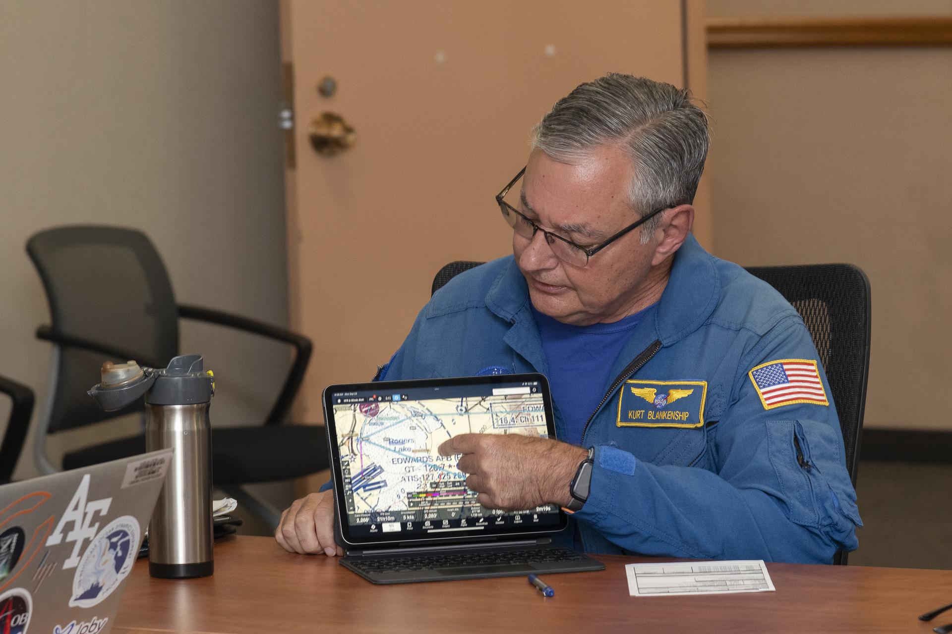
NASA pilot Kurt Blankenship maps out flight plans during a pre-flight brief. Pilots, crew, and researchers from NASA’s Armstrong Flight Research Center in Edwards, California and NASA’s Glenn Research Center in Cleveland are briefed on the flight plan to gather Automatic Dependent Surveillance-Broadcast signal data between the aircraft and ping-Stations on the ground at NASA Armstrong. These flights are the first cross-center research activity with the Pilatus-PC-12 at NASA Armstrong.
NASA/Steve Freeman
To simulate the conditions of an urban flight area and better understand signal loss patterns, NASA researchers established a test zone at NASA’s Armstrong Flight Research Center in Edwards, California, on Sept. 23 and 24, 2024.
Flying in the agency’s Pilatus PC-12 in a grid pattern over four ADS-B stations, researchers collected data on signal coverage from multiple ground locations and equipment configurations. Researchers were able to pinpoint where signal dropouts occurred from the strategically placed ground stations in connection to the plane’s altitude and distance from the stations. This data will inform future placement of additional ground stations to enhance signal boosting coverage.
“Like all antennas, those used for ADS-B signal reception do not have a constant pattern,” said Brad Snelling, vehicle test team chief engineer for NASA’s Air Mobility Pathfinders project. “There are certain areas where the terrain will block ADS-B signals and depending on the type of antenna and location characteristics, there are also flight elevation angles where reception can cause signal dropouts,” Snelling said. “This would mean we need to place additional ground stations at multiple locations to boost the signal for future test flights. We can use the test results to help us configure the equipment to reduce signal loss when we conduct future air taxi flight tests.”
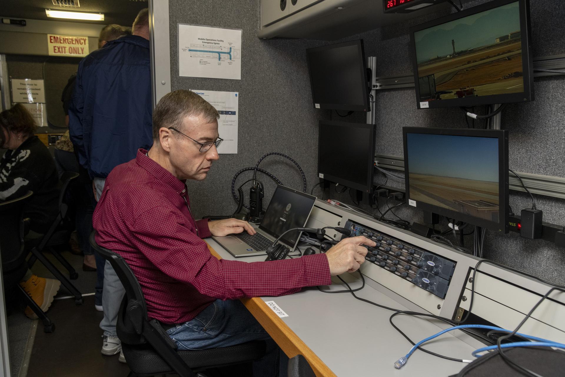
Working in the Mobile Operations Facility at NASA’s Armstrong Flight Research Center in Edwards, California, NASA Advanced Air Mobility researcher Dennis Iannicca adjusts a control board to capture Automatic Dependent Surveillance-Broadcast (ADS-B) data during test flights. The data will be used to understand ADS-B signal loss scenarios for air taxi flights in urban areas.
NASA/Steve Freeman
The September flights at NASA Armstrong built upon earlier tests of ADS-B in different environments. In June, researchers at NASA’s Glenn Research Center in Cleveland flew the Pilatus PC-12 and found a consistent ADS-B signal between the aircraft and communications antennas mounted on the roof of the center’sAerospace Communications Facility. Data from these flights helped researchers plan out the recent tests at NASA Armstrong. In December 2020, test flights performed under NASA’s Advanced Air Mobility National Campaign used an OH-58C Kiowa helicopter and ground-based ADS-B stations at NASA Armstrong to collect baseline signal information.
NASA’s research in ADS-B signals and other communication, navigation, and surveillance systems will help revolutionize U.S. air transportation. Air Mobility Pathfinders researchers will evaluate the data from the three separate flight tests to understand the different signal transmission conditions and equipment needed for air taxis and drones to safely operate in the National Air Space. NASA will use the results of this research to design infrastructure to support future air taxi communication, navigation, and surveillance research and to develop new ADS-B-like concepts for uncrewed aircraft systems.
A collage of artist concepts highlighting the novel approaches proposed by the 2025 NIAC awardees for possible future missions.
Credit: NASA/Left to Right: Saurabh Vilekar, Marco Quadrelli, Selim Shahriar, Gyula Greschik, Martin Bermudez, Ryan Weed, Ben Hockman, Robert Hinshaw, Christine Gregg, Ryan Benson, Michael Hecht
NASA selected 15 visionary ideas for its NIAC (NASA Innovative Advanced Concepts) program which develops concepts to transform future missions for the benefit of all. Chosen from companies and institutions across the United States, the 2025 Phase I awardees represent a wide range of aerospace concepts.
The NIAC program nurtures innovation by funding early-stage technology concept studies for future consideration and potential commercialization. The combined award for the 2025 concepts is a maximum of $2.625M in grants to evaluate technologies that could enable future aerospace missions.
“Our next steps and giant leaps rely on innovation, and the concepts born from NIAC can radically change how we explore deep space, work in low Earth orbit, and protect our home planet” said Clayton Turner, associate administrator for NASA’s Space Technology Mission Directorate in Washington. “From developing small robots that could swim through the oceans of other worlds to growing space habitats from fungi, this program continues to change the possible.”
The newly selected concepts include feasibility studies to explore the Sun’s influence on our solar system, build sustainable lunar habitats from glass, explore Saturn’s icy moon, and more. All NIAC studies are in the early stages of conceptual development and are not considered official NASA missions.
Ryan Weed, Helicity Space LLC in Pasadena, California, proposes a constellation of spacecraft powered by the Helicity Drive, a compact and scalable fusion propulsion system, that could enable rapid, multi-directional exploration of the heliosphere and beyond, providing unprecedented insights on how the Sun interacts with our solar system and interstellar space. Demonstrating the feasibility of fusion propulsion could also benefit deep space exploration including crewed missions to Mars.
Martin Bermudez, Skyeports LLC in Sacramento, California, presents the concept of constructing a large-scale, lunar glass habitat in a low-gravity environment. Nicknamed LUNGS (Lunar Glass Structure), this approach involves melting lunar glass compounds to create a large spherical shell structure. This idea offers a promising solution for establishing self-sustaining, large-scale habitats on the lunar surface.
Justin Yim, University of Illinois in Urbana, proposes a jumping robot appropriately named LEAP (Legged Exploration Across the Plume), as a novel robotic sampling concept to explore Enceladus, a small, icy moon of Saturn that’s covered in geysers, or jets. The LEAP robots could enable collection of pristine, ocean-derived material directly from Enceladus’s jets and measurement of particle properties across multiple jets by traveling from one to another.
“All advancements begin as an idea. The NIAC program allows NASA to invest in unique ideas enabling innovation and supporting the nation’s aerospace economy,” said John Nelson, program executive for NASA’s Innovative Advanced Concepts in Washington.
The NIAC researchers, known as fellows, will investigate the fundamental premise of their concepts, identify potential challenges, and look for opportunities to bring these concepts to life.
In addition to the projects mentioned above, the following selectees received 2025 NIAC Phase I grants:
NASA’s Space Technology Mission Directorate funds the NIAC program, as it is responsible for developing the agency’s new cross-cutting technologies and capabilities to achieve its current and future missions.
Preparations for Next Moonwalk Simulations Underway (and Underwater)
Danah Tommalieh, commercial pilot and engineer at Reliable Robotics, inputs a flight plan at the control center in Mountain View, California, ahead of remotely operating a Cessna 208 aircraft at Hollister municipal airport in Hollister, California.
NASA/Don Richey
NASA recently began a series of flight tests with partners to answer an important aviation question: What will it take to integrate remotely piloted or autonomous planes carrying large packages and cargo safely into the U.S. airspace? Researchers tested new technologies in Hollister, California, that are helping to investigate what tools and capabilities are needed to make these kinds of flights routine.
The commercial industry continues to make advancements in autonomous aircraft systems aimed at making it possible for remotely operated aircraft to fly over communities – transforming the way we will transport people and goods. As the Federal Aviation Administration (FAA) develops standards for this new type of air transportation, NASA is working to ensure these uncrewed flights are safe by creating the required technological tools and infrastructure. These solutions could be scaled to support many different remotely piloted aircraft – including air taxis and package delivery drones – in a shared airspace with traditional crewed aircraft.
“Remotely piloted aircraft systems could eventually deliver cargo and people to rural areas with limited access to commercial transportation and delivery services,” said Shivanjli Sharma, aerospace engineer at NASA’s Ames Research Center in California’s Silicon Valley. “We’re aiming to create a healthy ecosystem of many different kinds of remotely piloted operations. They will fly in a shared airspace to provide communities with better access to goods and services, like medical supply deliveries and more efficient transportation.”
During a flight test in November, Reliable Robotics, a company developing an autonomous flight system, remotely flew its Cessna 208 Caravan aircraft through pre-approved flight paths in Hollister, California.
Although a safety pilot was aboard, a Reliable Robotics remote pilot directed the flight from their control center in Mountain View, more than 50 miles away.
Cockpit of Reliable Robotics’ Cessna 208 aircraft outfitted with autonomous technology for remotely-piloted operations.
NASA/Brandon Torres Navarrete
Congressional staffers from the United States House and Senate’s California delegation joined NASA Deputy Associate Administrator for Aeronautics Research Mission Directorate, Carol Caroll, Ames Aeronautics Director, Huy Tran, and other Ames leadership at Reliable Robotics Headquarters to view the live remote flight.
Researchers evaluated a Collins Aerospace ground-based surveillance system’s ability to detect nearby air traffic and provide the remote pilot with information in order to stay safely separated from other aircraft in the future.
Initial analysis shows the ground-based radar actively surveilled the airspace during the aircraft’s taxi, takeoff, and landing. The data was transmitted from the radar system to the remote pilot at Reliable Robotics. In the future, this capability could help ensure aircraft remain safely separated across all phases of fight.
A Reliable Robotics’ modified Cessna 208 aircraft flies near Hollister Airport. A Reliable Robotics pilot operated the aircraft remotely from the control center in Mountain View.
NASA/Brandon Torres Naverrete
While current FAA operating rules require pilots to physically see and avoid other aircraft from inside the cockpit, routine remotely piloted aircraft will require a suite of integrated technologies to avoid hazards and coordinate with other aircraft in the airspace.
A radar system for ground-based surveillance offers one method for detecting other traffic in the airspace and at the airport, providing one part of the capability to ensure pilots can avoid collision and accomplish their desired missions. Data analysis from this testing will help researchers understand if ground-based surveillance radar can be used to satisfy FAA safety rules for remotely piloted flights.
NASA will provide analysis and reports of this flight test to the FAA and standards bodies.
“This is an exciting time for the remotely piloted aviation community,” Sharma said. “Among other benefits, remote operations could provide better access to healthcare, bolster natural disaster response efforts, and offer more sustainable and effective transportation to both rural and urban communities. We’re thrilled to provide valuable data to the industry and the FAA to help make remote operations a reality in the near future.”
Over the next year, NASA will work with additional aviation partners on test flights and simulations to test weather services, communications systems, and other autonomous capabilities for remotely piloted flights. NASA researchers will analyze data from these tests to provide a comprehensive report to the FAA and the community on what minimum technologies and capabilities are needed to enable and scale remotely piloted operations.
Preparations for Next Moonwalk Simulations Underway (and Underwater)
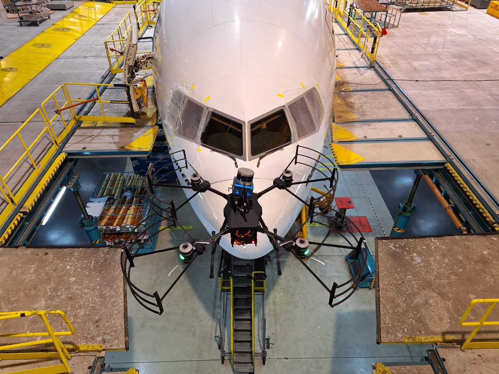
A Boeing 777-300ER aircraft is being inspected by one of Near Earth Autonomy’s drones Feb. 2, 2024, at an Emirates Airlines facility in Dubai, United Arab Emirates.
Near Earth Autonomy
A small business called Near Earth Autonomy developed a time-saving solution using drones for pre-flight checks of commercial airliners through a NASA Small Business Innovation Research (SBIR) program and a partnership with The Boeing Company.
Before commercial airliners are deemed safe to fly before each trip, a pre-flight inspection must be completed. This process can take up to four hours, and can involve workers climbing around the plane to check for any issues, which can sometimes result in safety mishaps as well as diagnosis errors.
With NASA and Boeing funding to bolster commercial readiness, Near Earth Autonomy developed a drone-enabled solution, under their business unit Proxim, that can fly around a commercial airliner and gather inspection data in less than 30 minutes. The drone can autonomously fly around an aircraft to complete the inspection by following a computer-programmed task card based on the Federal Aviation Administration’s rules for commercial aircraft inspection. The card shows the flight path the drone’s software needs to take, enabling aircraft workers with a new tool to increase safety and efficiency.
“NASA has worked with Near Earth Autonomy on autonomous inspection challenges in multiple domains,” says Danette Allen, NASA senior leader for autonomous systems.
“We are excited to see this technology spin out to industry to increase efficiencies, safety, and accuracy of the aircraft inspection process for overall public benefit.”
The photos collected from the drone are shared and analyzed remotely, which allows experts in the airline maintenance field to support repair decisions faster from any location. New images can be compared to old images to look for cracks, popped rivets, leaks, and other common issues.
The user can ask the system to create alerts if an area needs to be inspected again or fails an inspection. Near Earth Autonomy estimates that using drones for aircraft inspection can save the airline industry an average of $10,000 per hour of lost earnings during unplanned time on the ground.
Over the last six years, Near Earth Autonomy completed several rounds of test flights with their drone system on Boeing aircraft used by American Airlines and Emirates Airlines.
NASA’s Small Business Innovation Research / Small Business Technology Transfer program, managed by the agency’s Space Technology Mission Directorate, aims to bolster American ingenuity by supporting innovative ideas put forth by small businesses to fulfill NASA and industry needs. These research needs are described in annual SBIR solicitations and target technologies that have significant potential for successful commercialization.
Small business concerns with 500 or fewer employees, or small businesses partnering with a non-profit research institution such as a university or a research laboratory can apply to participate in the NASA SBIR/STTR program.