Preparations for Next Moonwalk Simulations Underway (and Underwater)
The C-20A aircraft, based at NASA’s Armstrong Flight Research Center in Edwards, California, flies over the Sierra Nevada Mountains in California for the Dense UAVSAR Snow Time (DUST) mission on Feb. 28, 2025. The DUST mission collected airborne data about snow water to help improve water management and reservoir systems on the ground.
NASA/Starr Ginn
As part of a science mission tracking one of Earth’s most precious resources – water – NASA’s C-20A aircraft conducted a series of seven research flights in March that can help researchers track the process and timeline as snow melts and transforms into a freshwater resource. The agency’s Uninhabited Aerial Vehicle Synthetic Aperture Radar (UAVSAR) installed on the aircraft collected measurements of seasonal snow cover and estimate the freshwater contained in it.
“Seasonal snow is a critical resource for drinking water, power generation, supporting multi-billion dollar agricultural and recreation industries,” said Starr Ginn, C-20A project manager at NASA’s Armstrong Flight Research Center in Edwards, California. “Consequently, understanding the distribution of seasonal snow storage and subsequent runoff is essential.”
The Dense UAVSAR Snow Time (DUST) mission mapped snow accumulation over the Sierra Nevada mountains in California and the Rocky Mountains in Idaho. Mission scientists can use these observations to estimate the amount of water stored in that snow.
Peter Wu, radar operator from NASA’s Jet Propulsion Laboratory in Southern California, observes data collected during the Dense UAVSAR Snow Time (DUST) mission onboard NASA’s C-20A aircraft on Feb. 28, 2025. The C-20A flew from NASA’s Armstrong Flight Research Center in Edwards, California, over the Sierra Nevada Mountains to collect data about snow water.
NASA/Starr Ginn
“Until recently, defining the best method for accurately measuring snow water equivalent (SWE) – or how much and when fresh water is converted from snow – has been a challenge,” said Shadi Oveisgharan, principal investigator of DUST and scientist at NASA’s Jet Propulsion Laboratory in Southern California. “The UAVSAR has been shown to be a good instrument to retrieve SWE data.”
Recent research has shown that snow properties, weather patterns, and seasonal conditions in the American West have been shifting in recent decades. These changes have fundamentally altered previous expectations about snowpack monitoring and forecasts of snow runoff. The DUST mission aims to better track and understand those changes to develop more accurate estimates of snow-to-water conversions and their timelines.
“We are trying to find the optimum window during which to retrieve snow data,” Oveisgharan said. “This estimation will help us better estimate available fresh snow and manage our reservoirs better.”
The Dense UAVSAR Snow Time (DUST) mission team assembles next to the C-20A aircraft at NASA’s Armstrong Flight Research Center in Edwards, California, on Feb. 28, 2025. From left, radar operator Adam Vaccaro, avionics lead Kelly Jellison, C-20A project manager Starr Ginn, pilot Carrie Worth, pilot Troy Asher, aircraft mechanic Eric Apikian, and operations engineer Ian Elkin.
NASA/Starr Ginn
The DUST mission achieved a new level of snow data accuracy, which is partly due to the specialized flight paths flown by the C-20A. The aircraft’s Platform Precision Autopilot (PPA) enables the team to fly very specific routes at exact altitudes, speeds, and angles so the UAVSAR can more precisely measure terrain changes.
“Imagine the rows made on grass by a lawn mower,” said Joe Piotrowski Jr., operations engineer for NASA Armstrong’s airborne science program. “The PPA system enables the C-20A to make those paths while measuring terrain changes down to the diameter of a centimeter.”
Scientists have hypothesized since the 1960s that the Sun is a source of ingredients that form water on the Moon. When a stream of charged particles known as the solar wind smashes into the lunar surface, the idea goes, it triggers a chemical reaction that could make water molecules.
Now, in the most realistic lab simulation of this process yet, NASA-led researchers have confirmed this prediction.
The finding, researchers wrote in a March 17 paper in JGR Planets, has implications for NASA’s Artemis astronaut operations at the Moon’s South Pole. A critical resource for exploration, much of the water on the Moon is thought to be frozen in permanently shadowed regions at the poles.
“The exciting thing here is that with only lunar soil and a basic ingredient from the Sun, which is always spitting out hydrogen, there’s a possibility of creating water,” Li Hsia Yeo, a research scientist at NASA’s Goddard Space Flight Center in Greenbelt, Maryland. “That’s incredible to think about,” said Yeo, who led the study.
Solar wind flows constantly from the Sun. It’s made largely of protons, which are nuclei of hydrogen atoms that have lost their electrons. Traveling at more than one million miles per hour, the solar wind bathes the entire solar system. We see evidence of it on Earth when it lights up our sky in auroral light shows.
Computer-processed data of the solar wind from NASA’s STEREO spacecraft. Download here: https://svs.gsfc.nasa.gov/12329
NASA/SwRI/Craig DeForest
Most of the solar particles don’t reach the surface of Earth because our planet has a magnetic shield and an atmosphere to deflect them. But the Moon has no such protection. As computer models and lab experiments have shown, when protons smash into the Moon’s surface, which is made of a dusty and rocky material called regolith, they collide with electrons and recombine to form hydrogen atoms.
Then, the hydrogen atoms can migrate through the lunar surface and bond with the abundant oxygen atoms already present in minerals like silica to form hydroxyl (OH) molecules, a component of water, and water (H2O) molecules themselves.
Scientists have found evidence of both hydroxyl and water molecules in the Moon’s upper surface, just a few millimeters deep. These molecules leave behind a kind of chemical fingerprint — a noticeable dip in a wavy line on a graph that shows how light interacts with the regolith. With the current tools available, though, it is difficult to tell the difference between hydroxyl and water, so scientists use the term “water” to refer to either one or a mix of both molecules.
Many researchers think the solar wind is the main reason the molecules are there, though other sources like micrometeorite impacts could also help by creating heat and triggering chemical reactions.
In 2016, scientists discovered that water is released from the Moon during meteor showers. When a speck of comet debris strikes the moon, it vaporizes on impact, creating a shock wave in the lunar soil. With a sufficiently large impactor, this shock wave can breach the soil’s dry upper layer and release water molecules from a hydrated layer below. NASA’s LADEE spacecraft detected these water molecules as they entered the tenuous lunar atmosphere. Download here: https://svs.gsfc.nasa.gov/20278/
NASA’s Goddard Space Flight Center Conceptual Image Lab
Spacecraft measurements had already hinted that the solar wind is the primary driver of water, or its components, at the lunar surface. One key clue, confirmed by Yeo’s team’s experiment: the Moon’s water-related spectral signal changes over the course of the day.
In some regions, it’s stronger in the cooler morning and fades as the surface heats up, likely because water and hydrogen molecules move around or escape to space. As the surface cools again at night, the signal peaks again. This daily cycle points to an active source — most likely the solar wind—replenishing tiny amounts of water on the Moon each day.
To test whether this is true, Yeo and her colleague, Jason McLain, a research scientist at NASA Goddard, built a custom apparatus to examine Apollo lunar samples. In a first, the apparatus held all experiment components inside: a solar particle beam device, an airless chamber that simulated the Moon’s environment, and a molecule detector. Their invention allowed the researchers to avoid ever taking the sample out of the chamber — as other experiments did — and exposing it to contamination from the water in the air.
“It took a long time and many iterations to design the apparatus components and get them all to fit inside,” said McLain, “but it was worth it, because once we eliminated all possible sources of contamination, we learned that this decades-old idea about the solar wind turns out to be true.”
Using dust from two different samples picked up on the Moon by NASA’s Apollo 17 astronauts in 1972, Yeo and her colleagues first baked the samples to remove any possible water they could have picked up between air-tight storage in NASA’s space-sample curation facility at NASA’s Johnson Space Center in Houston and Goddard’s lab. Then, they used a tiny particle accelerator to bombard the dust with mock solar wind for several days — the equivalent of 80,000 years on the Moon, based on the high dose of the particles used.
They used a detector called a spectrometer to measure how much light the dust molecules reflected, which showed how the samples’ chemical makeup changed over time.
In the end, the team saw a drop in the light signal that bounced to their detector precisely at the point in the infrared region of the electromagnetic spectrum — near 3 microns — where water typically absorbs energy, leaving a telltale signature.
While they can’t conclusively say if their experiment made water molecules, the researchers reported in their study that the shape and width of the dip in the wavy line on their graph suggests that both hydroxyl and water were produced in the lunar samples.
Preparations for Next Moonwalk Simulations Underway (and Underwater)
Editor’s Note: This article was updated April 16, 2025, to reflect the March 26 start date of NASA’s Alta X flights and provide additional details about the data collected.
Drones were a key part of testing new technology in support of a prescribed burn in Geneva State Forest, which is about 100 miles south of Montgomery, Alabama. The effort is part of the agency’s multi-year FireSense project, which is aimed at testing technologies that could eventually serve the U.S. Forest Service as well as local, state, and other federal wildland fire agencies. From left are Tim Wallace and Michael Filicchia of the Desert Research Institute in Nevada; Derek Abramson, Justin Hall, and Alexander Jaffe of NASA’s Armstrong Flight Research Center in Edwards California; and Alana Dachtler of International Met Systems of Kentwood, Michigan.
NASA/Jackie Shuman
Advancements in NASA’s airborne technology have made it possible to gather localized wind data and assess its impacts on smoke and fire behavior. This information could improve wildland fire decision making and enable operational agencies to better allocate firefighters and resources. A small team from NASA’s Armstrong Flight Research Center in Edwards, California, is demonstrating how some of these technologies work.
Two instruments from NASA’s Langley Research Center in Hampton, Virginia – a sensor gathering 3D wind data and a radiosonde that measures temperature, barometric pressure, and relative humidity data – were installed on NASA Armstrong’s Alta X drone for a prescribed burn in Geneva State Forest, which is about 100 miles south of Montgomery, Alabama. The effort is part of the agency’s multi-year FireSense project, which is aimed at testing technologies that could eventually serve the U.S. Forest Service as well as local, state, and other federal wildland fire agencies.
“The objectives for the Alta X portion of the multi-agency prescribed burn include a technical demonstration for wildland fire practitioners, and data collection at various altitudes for the Alabama Forestry Commission operations,” said Jennifer Fowler, FireSense project manager. “Information gathered at the different altitudes is essential to monitor the variables for a prescribed burn.”
Those variables include the mixing height, which is the extent or depth to which smoke will be dispersed, a metric Fowler said is difficult to predict. Relative humidity must also be above 30% for a prescribed burn to meet requirements in Geneva State Forest. The technology to collect these measurements locally is not readily available in wildland fire operations, making the Alta X and its instruments key in the demonstration of prescribed burn technology.
A drone from NASA’s Armstrong Flight Research Center, Edwards, California, flies with a sensor to gather 3D wind data and a radiosonde that measures temperature, barometric pressure, and humidity data from NASA’s Langley Research Center in Hampton, Virginia. The drone and instruments supported a prescribed burn in Geneva State Forest, which is about 100 miles south of Montgomery, Alabama. The effort is part of the agency’s multi-year FireSense project, which is aimed at testing technologies that could eventually serve the U.S. Forest Service as well as local, state, and other federal wildland fire agencies.
International Met Systems/Alana Dachtler
In addition to the Alta X flights beginning March 26, NASA Armstrong’s B200 King Air will fly over actively burning fires at an altitude of about 6,500 feet. Sensors onboard other aircraft supporting the mission will fly at lower and higher altitudes before, during, and after the fire for required data collection. The multi-agency mission will provide data to improve models to better predict fire behavior and effects, including smoke lofting, trajectory, and dispersion.
Small, uncrewed aircraft system pilots from NASA Armstrong completed final preparations to travel to Alabama and set up for the research flights. The team – including Derek Abramson, chief engineer for the subscale flight research laboratory; Justin Hall, NASA Armstrong chief pilot of small, uncrewed aircraft systems; and Alexander Jaffe, a drone pilot – will set up, fly, observe airborne operations, all while keeping additional aircraft batteries charged. The launch and recovery of the Alta X is manual, the mission profile is flown autonomously to guarantee the same conditions for data collection.
“The flight profile is vertical – straight up and straight back down from the surface to about 3,000 feet altitude,” Abramson said. “We will characterize the mixing height and changes in moisture, mapping out how they both change throughout the day in connection with the burn.”
In August 2024, a team of NASA researchers used the NASA Langley Alta X and weather instruments in Missoula, Montana, for a FireSense project drone technology demonstration. These instruments were used to generate localized forecasting that provides precise and sustainable meteorological data to predict fire behavior and smoke impacts.
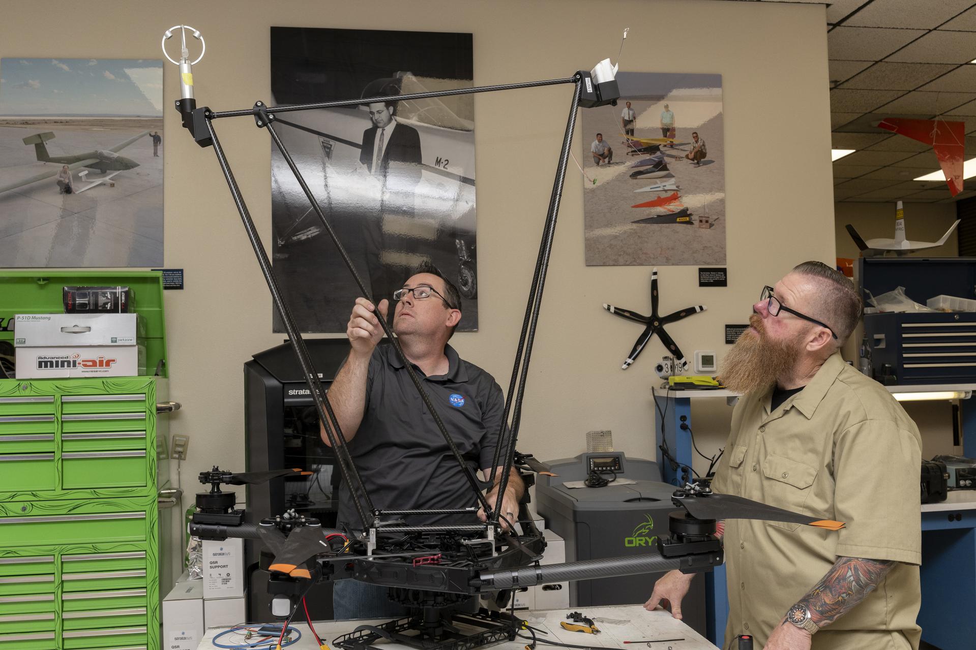
Justin Link, left, pilot for small uncrewed aircraft systems, and Justin Hall, chief pilot for small uncrewed aircraft systems, install weather instruments on an Alta X drone at NASAs Armstrong Flight Research Center in Edwards, California. Members of the center’s Dale Reed Subscale Flight Research Laboratory used the Alta X to support the agency’s FireSense project in March 2025 for a prescribed burn in Geneva State Forest, which is about 100 miles south of Montgomery, Alabama.