This artist’s concept visualizes a super-Neptune world orbiting a low-mass star near the center of our Milky Way galaxy. Scientists recently discovered such a system that may break the current record for fastest exoplanet system, traveling at least 1.2 million miles per hour, or 540 kilometers per second.
NASA/JPL-Caltech/R. Hurt (Caltech-IPAC)
Astronomers may have discovered a scrawny star bolting through the middle of our galaxy with a planet in tow. If confirmed, the pair sets a new record for the fastest-moving exoplanet system, nearly double our solar system’s speed through the Milky Way.
The planetary system is thought to move at least 1.2 million miles per hour, or 540 kilometers per second.
“We think this is a so-called super-Neptune world orbiting a low-mass star at a distance that would lie between the orbits of Venus and Earth if it were in our solar system,” said Sean Terry, a postdoctoral researcher at the University of Maryland, College Park and NASA’s Goddard Space Flight Center in Greenbelt, Maryland. Since the star is so feeble, that’s well outside its habitable zone. “If so, it will be the first planet ever found orbiting a hypervelocity star.”
The pair of objects was first spotted indirectly in 2011 thanks to a chance alignment. A team of scientists combed through archived data from MOA (Microlensing Observations in Astrophysics) – a collaborative project focused on a microlensing survey conducted using the University of Canterbury Mount John Observatory in New Zealand — in search of light signals that betray the presence of exoplanets, or planets outside our solar system.
Microlensing occurs because the presence of mass warps the fabric of space-time. Any time an intervening object appears to drift near a background star, light from the star curves as it travels through the warped space-time around the nearer object. If the alignment is especially close, the warping around the object can act like a natural lens, amplifying the background star’s light.
This artist’s concept visualizes stars near the center of our Milky Way galaxy. Each has a colorful trail indicating its speed –– the longer and redder the trail, the faster the star is moving. NASA scientists recently discovered a candidate for a particularly speedy star, visualized near the center of this image, with an orbiting planet. If confirmed, the pair sets a record for fastest known exoplanet system.
NASA/JPL-Caltech/R. Hurt (Caltech-IPAC)
In this case, microlensing signals revealed a pair of celestial bodies. Scientists determined their relative masses (one is about 2,300 times heavier than the other), but their exact masses depend on how far away they are from Earth. It’s sort of like how the magnification changes if you hold a magnifying glass over a page and move it up and down.
“Determining the mass ratio is easy,” said David Bennett, a senior research scientist at the University of Maryland, College Park and NASA Goddard, who co-authored the new paper and led the original study in 2011. “It’s much more difficult to calculate their actual masses.”
The 2011 discovery team suspected the microlensed objects were either a star about 20 percent as massive as our Sun and a planet roughly 29 times heavier than Earth, or a nearer “rogue” planet about four times Jupiter’s mass with a moon smaller than Earth.
To figure out which explanation is more likely, astronomers searched through data from the Keck Observatory in Hawaii and ESA’s (European Space Agency’s) Gaia satellite. If the pair were a rogue planet and moon, they’d be effectively invisible – dark objects lost in the inky void of space. But scientists might be able to identify the star if the alternative explanation were correct (though the orbiting planet would be much too faint to see).
They found a strong suspect located about 24,000 light-years away, putting it within the Milky Way’s galactic bulge — the central hub where stars are more densely packed. By comparing the star’s location in 2011 and 2021, the team calculated its high speed.
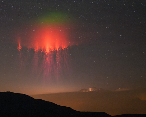
This Hubble Space Telescope image shows a bow shock around a very young star called LL Ori. Named for the crescent-shaped wave made by a ship as it moves through water, a bow shock can be created in space when two streams of gas collide. Scientists think a similar feature may be present around a newfound star that could be traveling at least 1.2 million miles per hour, or 540 kilometers per second. Traveling at such a high velocity in the galactic bulge (the central part of the galaxy) where gas is denser could generate a bow shock.
NASA and The Hubble Heritage Team (STScI/AURA); Acknowledgment: C. R. O’Dell (Vanderbilt University)
But that’s just its 2D motion; if it’s also moving toward or away from us, it must be moving even faster. Its true speed may even be high enough to exceed the galaxy’s escape velocity of just over 1.3 million miles per hour, or about 600 kilometers per second. If so, the planetary system is destined to traverse intergalactic space many millions of years in the future.
“To be certain the newly identified star is part of the system that caused the 2011 signal, we’d like to look again in another year and see if it moves the right amount and in the right direction to confirm it came from the point where we detected the signal,” Bennett said.
“If high-resolution observations show that the star just stays in the same position, then we can tell for sure that it is not part of the system that caused the signal,” said Aparna Bhattacharya, a research scientist at the University of Maryland, College Park and NASA Goddard who co-authored the new paper. “That would mean the rogue planet and exomoon model is favored.”
NASA’s upcoming Nancy Grace Roman Space Telescope will help us find out how common planets are around such speedy stars, and may offer clues to how these systems are accelerated. The mission will conduct a survey of the galactic bulge, pairing a large view of space with crisp resolution.
“In this case we used MOA for its broad field of view and then followed up with Keck and Gaia for their sharper resolution, but thanks to Roman’s powerful view and planned survey strategy, we won’t need to rely on additional telescopes,” Terry said. “Roman will do it all.”
This artist’s illustration represents the results from a new study that examines the effects of X-ray and other high-energy radiation unleashed on potential exoplanets from Wolf 359, a nearby red dwarf star. Researchers used Chandra and XMM-Newton to study the impact of steady X-ray and energetic ultraviolet radiation from Wolf 359 on the atmospheres of planets that might be orbiting the star. They found that only a planet with greenhouse gases like carbon dioxide in its atmosphere and at a relatively large distance away from Wolf 359 would have a chance to support life as we know it.
X-ray: NASA/CXC/SAO/S.Wolk, et al.; Illustration: NASA/CXC/SAO/M.Weiss; Image processing: NASA/CXC/SAO/N. Wolk
Planets around other stars need to be prepared for extreme weather conditions, according to a new study from NASA’s Chandra X-ray Observatory and ESA’s (European Space Agency’s) XMM-Newton that examined the effects of X-rays on potential planets around the most common type of stars.
Astronomers found that only a planet with greenhouse gases in its atmosphere like Earth and at a relatively large distance away from the star they studied would have a chance to support life as we know it around a nearby star.
Wolf 359 is a red dwarf with a mass about a tenth that of the Sun. Red dwarf stars are the most common stars in the universe and live for billions of years, providing ample time for life to develop. At a distance of only 7.8 light-years away, Wolf 359 is also one of the closest stars to the solar system.
“Wolf 359 can help us unlock the secrets around stars and habitability,” said Scott Wolk of the Center for Astrophysics | Harvard & Smithsonian (CfA), who led the study. “It’s so close and it belongs to such an important class of stars – it’s a great combination.”
Because red dwarfs are the most prevalent types of stars, astronomers have looked hard to find exoplanets around them. Astronomers have found some evidence for two planets in orbit around Wolf 359 using optical telescopes, but those conclusions have been challenged by other scientists.
“While we don’t have proof of planets around Wolf 359 yet, it seems very possible that it hosts multiple planets,” Wolk added. “This makes it an excellent test bed to look at what planets would experience around this kind of star.”
Wolk and his colleagues used Chandra and XMM to study the amounts of steady X-rays and extreme ultraviolet (UV) radiation – the most energetic type of UV radiation – that Wolf 359 would unleash on the possible planets around it.
They found that Wolf 359 is producing enough damaging radiation that only a planet with greenhouse gases like carbon dioxide in its atmosphere – and located at a relatively large distance from the star – would likely be able to sustain life.
“Just being far enough away from the star’s harmful radiation wouldn’t be enough to make it habitable,” said co-author Vinay Kashyap, also of CfA. “A planet around Wolf 359 would also need to be blanketed in greenhouse gases like Earth is.”
To study the effects of energetic radiation on the habitability of the planet candidates, the team considered the star’s habitable zone – the region around a star where liquid water could exist on a planet’s surface.
The outer limit of the habitable zone for Wolf 359 is about 15% of the distance between Earth and the Sun, because the red dwarf is much less bright than the Sun. Neither of the planet candidates for this system is located in Wolf 359’s habitable zone, with one too close to the star and the other too far out.
“If the inner planet is there, the X-ray and extreme UV radiation it is subjected to would destroy the atmosphere of this planet in only about a million years,” said co-author Ignazio Pillitteri of CfA and the National Institute for Astrophysics in Palermo, Italy.
The team also considered the effects of radiation on as-yet undetected planets within the habitable zone. They concluded that a planet like the Earth in the middle of the habitable zone should be able to sustain an atmosphere for almost two billion years, while one near the outer edge could last indefinitely, helped by the warming effects of greenhouse gases.
Another big danger for planets orbiting stars like Wolf 359 is from X-ray flares, or occasional bright bursts of X-rays, on top of the steady, everyday output from the star. Combining observations made with Chandra and XMM-Newton resulted in the discovery of 18 X-ray flares from Wolf 359 over 3.5 days.
Extrapolating from these observed flares, the team expects that much more powerful and damaging flares would occur over longer periods of time. The combined effects of the steady X-ray and UV radiation and the flares mean that any planet located in the habitable zone is unlikely to have a significant atmosphere long enough for multicellular life, as we know it on Earth, to form and survive. The exception is the habitable zone’s outer edge if the planet has a significant greenhouse effect.
These results were presented at the 245th meeting of the American Astronomical Society in National Harbor, Maryland, and are being prepared for publication in a journal. NASA’s Marshall Space Flight Center in Huntsville, Alabama, manages the Chandra program. The Smithsonian Astrophysical Observatory’s Chandra X-ray Center controls science operations from Cambridge, Massachusetts, and flight operations from Burlington, Massachusetts.
But we’re not stopping to rest on our laurels. In 2024, NASA selected 25 new citizen science proposals for funding that will lead to new projects and new results to look forward to in 2025 and beyond. Here’s a roundup of those selections and the principal investigators (PIs) of each team—a sneak peek at what’s coming next in NASA citizen science! Note that these investigations are research grants–some of them will result in new opportunities for the public, others will use results from earlier citizen science projects or develop new tools.
Bright green glow observed from Texas on June 1, 2024, by Stephen Hummel. A new grant to the Spritacular project team will support citizen science research on this newly-discovered phenomenon.
Stephen Hummel
Citizen Science Seed Funding Program (CSSFP)
The CSSFP aims to support scientists and other experts to develop citizen science projects and to expand the pool of scientists who use citizen science techniques in their science investigations. Four divisions of NASA’s Science Mission Directorate are participating in the CSSFP: the Astrophysics Division, the Biological and Physical Sciences Division, the Heliophysics Division, and the Planetary Science Division. Nine new investigations were recently selected through this program:
Astrophysics Division
SuPerPiG Observing Grid, PI RachelHuchmala, Boise State University. Use a small telescope to monitor exoplanets to improve our knowledge of their orbits.
Understanding the Nature of Clumpy Galaxies with Clump-Scout 2: a New Citizen-Science Project to Characterize Star-Forming Clumps in Nearby Galaxies. PI Claudia Scarlata, University of Minnesota. Label clumps of distant galaxies to help us understand Hubble Space Telescope data.
‘Backyard Worlds: Binaries’ — Discovering Benchmark Brown Dwarfs Through Citizen Science. PI Aaron Meisner, NSF’s NOIRLab. Search for planet-like objects called brown dwarfs that orbit nearby stars.
Mobile Toolkits to Enable Transient Follow-up Observations by Amateur Astronomers. PI Michael Coughlin, University of Minnesota. Use your own telescope to observe supernovae, kilonovae and other massive explosions.
Planetary Science Division
A Citizen Scientist Approach to High Resolution Geologic Mapping of Intracrater Impact Melt Deposits as an input to Numerical Models, PI Kirby Runyon, Planetary Science Institute. Help map lunar craters so we can better understand how meteor impacts sculpt the moon’s surface.
Identifying Active Asteroids in Public Datasets, PI Chad Trujillo, Northern Arizona University, Search for icy, comet-like bodies hiding in the asteroid belt using new data from the Canada-France-Hawaii telescope.
Heliophysics Division
Enabling Magnetopause Observations With Informal Researchers (EMPOWR). PI Mo Wenil, Johns Hopkins University. Investigate plasma layers high above the Earth using data from NASA’s Magnetospheric Multiscale (MMS) mission and the Zooniverse platform.
High-resolution Ionospheric Imaging using Dual-Frequency Smartphones. PI Josh Semeter, Boston University. Study the upper atmosphere using cell phone signals.
Large Scale Structures Originating from the Sun (LASSOS) multi-point catalog: A citizen project connecting operations to research. PI Cecelia Mac Cormack, Catholic University of America. Help build a catalog of structures on the Sun.
Comet Identification and Image Annotation Modernization for the Sungrazer Citizen Science Project. PI Oliver Gerland. Search for comets in data from ESA and NASA’s Solar and Heliospheric Observatory (SOHO) mission using new web tools.
The HCSI program supports medium-scale citizen science projects in the Heliophysics Division of NASA’s Science Mission Directorate. Six investigations were recently selected through this program:
Investigation of green afterglow observed above sprite and gigantic jet tops based on Spritacular project database, PI Burcu Kosar. Photograph electric phenomena above storm clouds to help us understand a newly discovered green glow and learn about atmospheric chemistry.
Machine Learning competition for Solar Wind prediction in preparation of solar maximum. PI Enrico Camporeale, University of Colorado, Boulder. Take part in a competition to predict the speed of the solar wind using machine learning.
A HamSCI investigation of the bottomside ionosphere during the 2023 annular and 2024 total solar eclipses. PI Gareth Perry, New Jersey Institute of Technology. Use Ham Radio data to investigate the effects of solar eclipses on the ionosphere.
Dynamic footprint in mid-latitude mesospheric clouds. PI Chihiko Cullens, University of Colorado, Boulder. Collect and analyze data on noctilucent clouds, rare high-altitude clouds that shine at night.
Monitoring Solar Activity During Solar Cycle 25 with the GAVRT Solar Patrol Science and Education Program. PI Marin Anderson, Jet Propulsion Laboratory. Track solar activity during the period leading up to and including solar maximum.
What is the total energy input to the heliosphere from solar jets? PI Nour Rawafi, The Johns Hopkins University Applied Physics Laboratory. Identify solar jets in images from the Solar Dynamics Observatory
Citizen Science for Earth Systems Program (CSESP)
CSESP opportunities focus on developing and implementing projects that harness contributions from members of the general public to advance our understanding of Earth as a system. Proposals for the 2024 request were required to demonstrate a clear link between citizen science and NASA observation systems to advance the agency’s Earth science mission. Nine projects received funding.
Engaging Citizen Scientists for Inclusive Earth Systems Monitoring, PI Duan Biggs, Northern Arizona University. Measure trees in tropical regions south of the equator with the GLOBE Observer App to improve models of vegetation structure and biomass models from NASA’s Global Ecosystem Dynamics Investigation (GEDI) mission.
Integrating Remote Sensing and Citizen Science to Support Conservation of Woodland Vernal Pools, PI Laura Bourgeau-Chavez, Michigan Technological University. Map and monitor shallow, seasonal wetlands in Michigan, Wisconsin and New York to better understand these key habitats of amphibians and other invertebrates.
Citizen-Enabled Measurement of PM2.5 and Black Carbon: Addressing Local Inequities and Validating PM Composition from MAIA, Albert Presto/Carnegie Mellon University. Deploy sensors to measure sources of fine airborne particle pollution filling gaps in data from NASA’s Multi-Angle Imager for Aerosols (MAIA) mission.
Expanding Citizen Science Hail Observations for Validation of NASA Satellite Algorithms and Understanding of Hail Melt, PI Russ Schumacher, Colorado State University. Measure the sizes and shapes of hailstones, starting in the southeastern United States, using photographs and special pads to help us understand microwave satellite data.
X-Snow: A Citizen-Science Proposal for Snow in the New York Area, PI, Marco Tedesco, Columbia University. Measure snow in the Catskill and Adirondacks regions of New York to help improve NASA’s models of snow depth and water content.
Coupling Citizen Science and Remote Sensing Observations to Assess the Impacts of Icebergs on Coastal Arctic Ecosystems, PI, Maria Vernet, University of California, San Diego. Measure phytoplankton samples in polar regions to understand how icebergs and their meltwater affect phytoplankton concentration and biodiversity.
Forecasting Mosquito-Borne Disease Risk in a Changing Climate: Integrating GLOBE Citizen Science and NASA Earth System Modeling, PI Di Yang, University of Florida, Gainesville. Using data on mosquitoes from the GLOBE Observer App to predict future changes in mosquito-borne disease risk.
Ozone Measurements from General Aviation: Supporting TEMPO Satellite Validation and Addressing Air Quality Issues in California’s San Joaquin Valley with Citizen Science, PI Emma Yates, NASA Ames Research Center. Deploy air-quality sensors around Bakersfield, California and compare the data to measurements from NASA’s Tropospheric Emissions Monitoring of Pollution instrument (TEMPO).
Under the Canopy: Capturing the Role of Understory Phenology on Animal Communities Using Citizen Science, PI Benjamin Zuckerberg, University of Wisconsin, Madison. Measure snow depth, temperature, and sound in forest understories to improve satellite-based models of vegetation and snow cover for better modeling of wildlife communities.
For more information on citizen science awards from previous years, see articles from:
Summary of the 2024 NASA LCLUC Science Team Meeting
Introduction
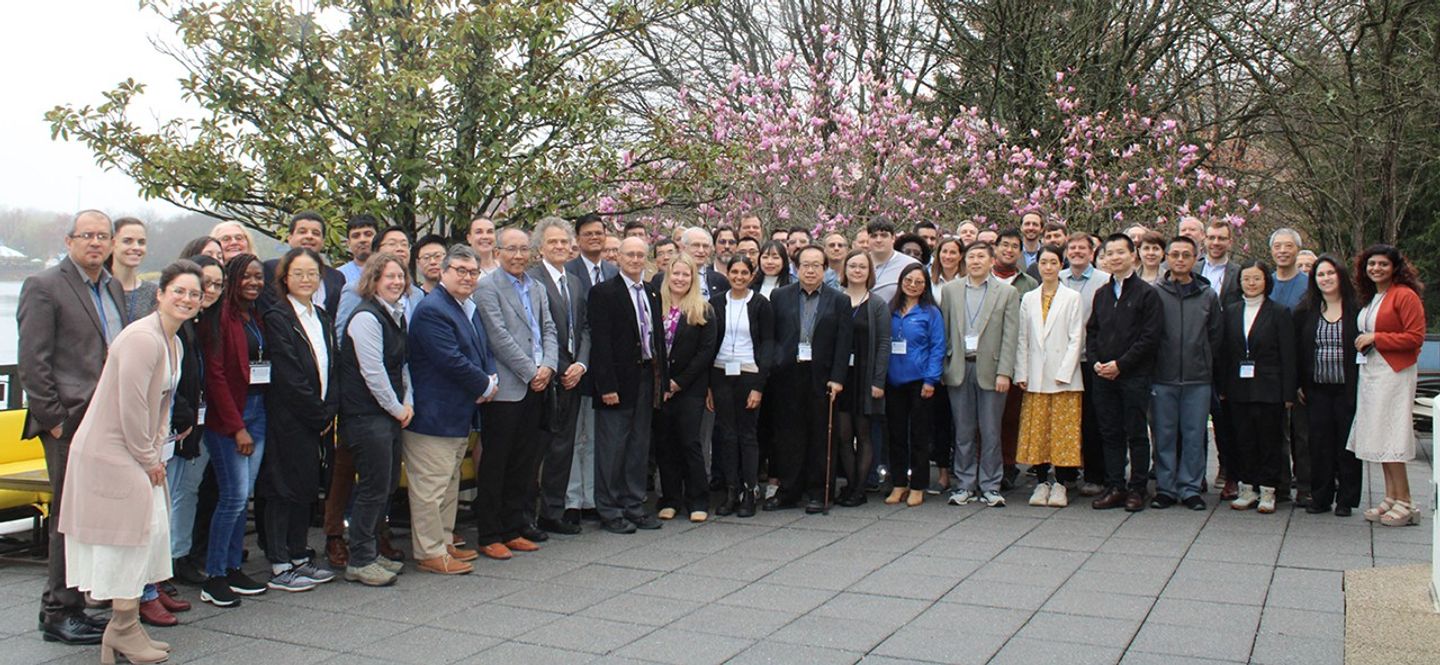
The 2024 NASA Land-Cover and Land-Use Change (LCLUC) Science Team Meeting (STM) took place from April 2–4, 2024 at the Marriott Washingtonian Center in Gaithersburg, MD. During the meeting, 75 people attended in-person. Represented among the attendees were LCLUC project investigators and collaborators, NASA Headquarters (HQ) program managers, and university researchers and students – see Photo.
LCLUC is an interdisciplinary scientific program within NASA’s Earth Science program that aims to develop the capability for periodic global inventories of land use and land cover from space. The program’s goal is to develop the scientific understanding and models necessary to simulate the processes taking place and to evaluate the consequences of observed and predicted changes.
The LCLUC program’s focus is divided into three areas – impacts, monitoring, and synthesis. Each category constitutes about one-third of the program’s content. The LCLUC program is part of the Carbon Cycle and Ecosystems research area, alongside other programs, such as Terrestrial Ecosystems, Ocean Biology and Biogeochemistry, and Biodiversity.
Principal Investigators (PIs) who participate in LCLUC are required to provide free and open access to their data and products via their metadata pages, aligning with NASA’s Transform to Open Science (TOPS) initiative. The program organizes at least one international regional workshop and one domestic ST meeting each year to share LCLUC science and foster global collaborations, contributing to regional capacity-building as an added value. Additionally, the program hosts regular webinars led by PIs on topics such as agriculture, urban areas, land-use changes in conflict zones, and natural disaster hotspots (i.e., fires, droughts, and floods). Garik Gutman [NASA HQ—LCLUC Program Manager] presented updates on LCLUC research publications, journal special issues, and upcoming international meetings.
The remainder of this article summarizes the highlights of the 2024 LCLUC STM. The content is organized chronologically, with a section devoted to describing each day of the meeting and descriptive headers throughout. The full presentations from this meeting are available on the LCLUC meeting website.
Photo. A group picture of meeting participants on the first day of the 2024 LCLUC meeting in Gaithersburg, MD.
Photo credit: Hotel staff (Marriott Washingtonian Center, Gaithersburg, MD)
DAY ONE
The first day featured invited presentations, reports from LCLUC ST members funded through the LCLUC Research Opportunities in Space and Earth Sciences (ROSES) 2022 selections, and an overview of SARI. The day concluded with poster presentations and lightning talks highlighting recent results from ongoing LCLUC-related research.
Update from the LCLUC Program Manager
The meeting began with welcoming remarks from Garik Gutman, who provided an update on the program’s latest developments and achievements. He highlighted that the socioeconomic component is an integral part of most LCLUC projects. The program has recently expanded to include multisource land imaging, such as the ESA’s Copernicus Sentinel program, regional initiatives, and capacity-building efforts. He also underscored the importance of U.S. missions relevant to LCLUC, which produce spatially coarse resolution daily data from the Moderate Resolution Imaging Spectroradiometer (MODIS) on NASA’s Aqua and Terra platforms and the NASA–National Oceanic and Atmospheric Administration (NOAA) Visible Infrared Imaging Radiometer Suite (VIIRS) on the Suomi National Polar-orbiting Partnership (Suomi NPP); spatially moderate resolution data every eight days from the NASA–USGS Landsat-8 (L8) and Landsat-9 (L9) satellites; and very high-resolution data from private companies, such as Planet Inc. and Maxar.
Jack Kaye [ESD—Associate Director for Research] gave an update on ESD activities that reflected on NASA’s broad capabilities in Earth Science – emphasizing the agency’s unique role in both developing and utilizing cutting-edge technology. Unlike many other agencies, NASA’s scope spans technology development, research, data provision, and tool creation. Over the past 16 months, NASA has launched several significant missions, including SWOT, Time-Resolved Observations of Precipitation structure and storm Intensity with a Constellation of Smallsats (TROPICS), Tropospheric Emissions: Monitoring of Pollution (TEMPO), and Plankton, Aerosol, Cloud, ocean Ecosystem (PACE). This surge in satellite launches highlights NASA’s role in enhancing global observational capabilities. NASA also supports a diverse array of programs, including airborne campaigns and surface-based measurement networks. Initiatives aim to improve the involvement of minority-serving institutions and incorporate open science practices with a focus on enhancing inclusivity and expanding participation. The agency also emphasizes the importance of peer review and collaboration with international and community-based partners. Kaye highlighted NASA’s commitment to producing high-quality, actionable science while navigating financial and operational challenges. This commitment extends to addressing environmental and societal impacts through programs such as Earth Action and by fostering global collaboration.
Sid Ahmed Boukabara [ESD—Senior Program Scientist for Strategy] presented a detailed overview of NASA’s Earth Science to Action Strategy, which aims to increase the impact of Earth science in addressing global challenges. This strategy acknowledges the urgency of global changes, e.g., accelerating environmental shifts, understanding Earth’s interconnected systems, and developing scalable information. NASA’s mission focuses on observing and understanding the Earth system, delivering trusted information, and empowering resilience activities through advanced technologies, partnerships, and innovations. Key principles include amplifying impact through partnerships, engaging a diverse and inclusive workforce, balancing innovation with sustainability, encouraging cutting-edge capabilities, and ensuring robust and resilient processes. The strategy emphasizes collaboration across sectors and international partnerships to leverage Earth observations enhance the value of Earth science for decision-making and policy support. The strategy also highlights the role of land-cover and land-use change activities in supporting objectives and enhancing modeling capabilities.
Thomas Wagner [ESD—Associate Director for Earth Action] outlined NASA’s Earth Action initiative (formerly known as the Applications Program), which focuses on user-centered strategies to address global challenges, e.g., climate resilience, health, and ecological conservation. By integrating applied sciences and leveraging satellite data, the initiative aims to enhance Earth observation capabilities and connect scientific research with practical applications to meet societal needs. The strategy includes a virtuous cycle, where user feedback informs the development of future programs and missions, ensuring that research and technology are aligned with real-world needs. Additionally, Earth Action emphasizes public engagement by offering open-source models and data to enhance understanding and support decision making. Through multisector consortia and problem-solving teams, the initiative addresses urgent and broad-impact issues, fostering innovation and collaboration.
Updates from LCLUC PIs on 2022 ROSES Proposal Selections
Following the programmatic overview presentations, PIs presented updates on research results from LCLUC ROSES 2022 proposal selections. Gillian Galford [University of Vermont] presented on the socioeconomic and environmental dynamics of LCLUC in the Cerrado frontier of Brazil. She presented results from the three main objectives: developing LCLUC detection methods and datasets, characterizing major land-use transitions (LUTs), and understanding the drivers behind these transitions. The research employs remote-sensing and geostatistical methods to track changes, identify “hotspots” of activity, and understand the underlying motivations for land-use changes. The research aims to provide insights that can guide conservation efforts and promote sustainable land use in the region.
Gustavo Oliveira [Clark University] presented “Irrigation as Climate-Change Adaptation in the Cerrado Biome of Brazil.” This project aims to develop methods for analyzing LCLUC data and their socioeconomic impacts, examining the expansion of irrigated agriculture and creating models to inform policy on agrarian development and water regulations. Oliveira highlighted areas of significant deforestation and the rapid growth of irrigated agriculture in the study region – positioning Western Bahia as a model for irrigation in Brazil. He explained that the research outputs include software for time series analysis and publications on land change, contributing to the broader understanding of climate adaptation strategies in the region.
Grant Connette [Smithsonian Institution] presented “Can Improved Stakeholder Representation Prevent Human-caused Mangrove Loss in the Mesoamerican Reef Ecoregion?” He examined the factors contributing to mangrove loss in the Mesoamerican Reef (MAR) ecoregion. Through a combination of Earth observation data, socioeconomic analysis, and community engagement, Connette described how the study seeks to improve the effectiveness of protected areas and inform best practices for mangrove conservation in the MAR ecoregion.
Saurav Kumar [Arizona State University] presented his team’s work, “Exploring the Nexus between LCLUC, Socio-Economic Factors, and Water for a Vulnerable Arid U.S.–Mexico Transboundary Region.” Kumar explained that the project aims to understand how natural and human systems influence LCLUC when constrained by water availability. The data used in this project come from a combination of time series data, theoretical model output, and artificial intelligence techniques. The team also focuses on stakeholder engagement, recognizing the need for comprehensive identification and involvement in addressing complex water resource issues. Kumar explained that the study seeks to predict future LCLUC transitions, assess the theoretical models of different stakeholder groups, and identify policy-relevant leverage points for sustainable water management.
Abena Boatemaa Asare-Ansah [University of Maryland, College Park (UMD)] presented on “The Multisensor Mapping of Refugee Agricultural LCLUC Hotspots in Uganda.” She explained that this study focuses on mapping changes in cropland within refugee-hosting regions using satellite data and deep learning models. Asare-Ansah described how the first year involved evaluating existing cropland maps and initiating new classifications. Future work will refine these maps and connect cropland changes to specific refugee households, aiming to better understand the relationship between refugee populations, food aid, and agricultural practices.
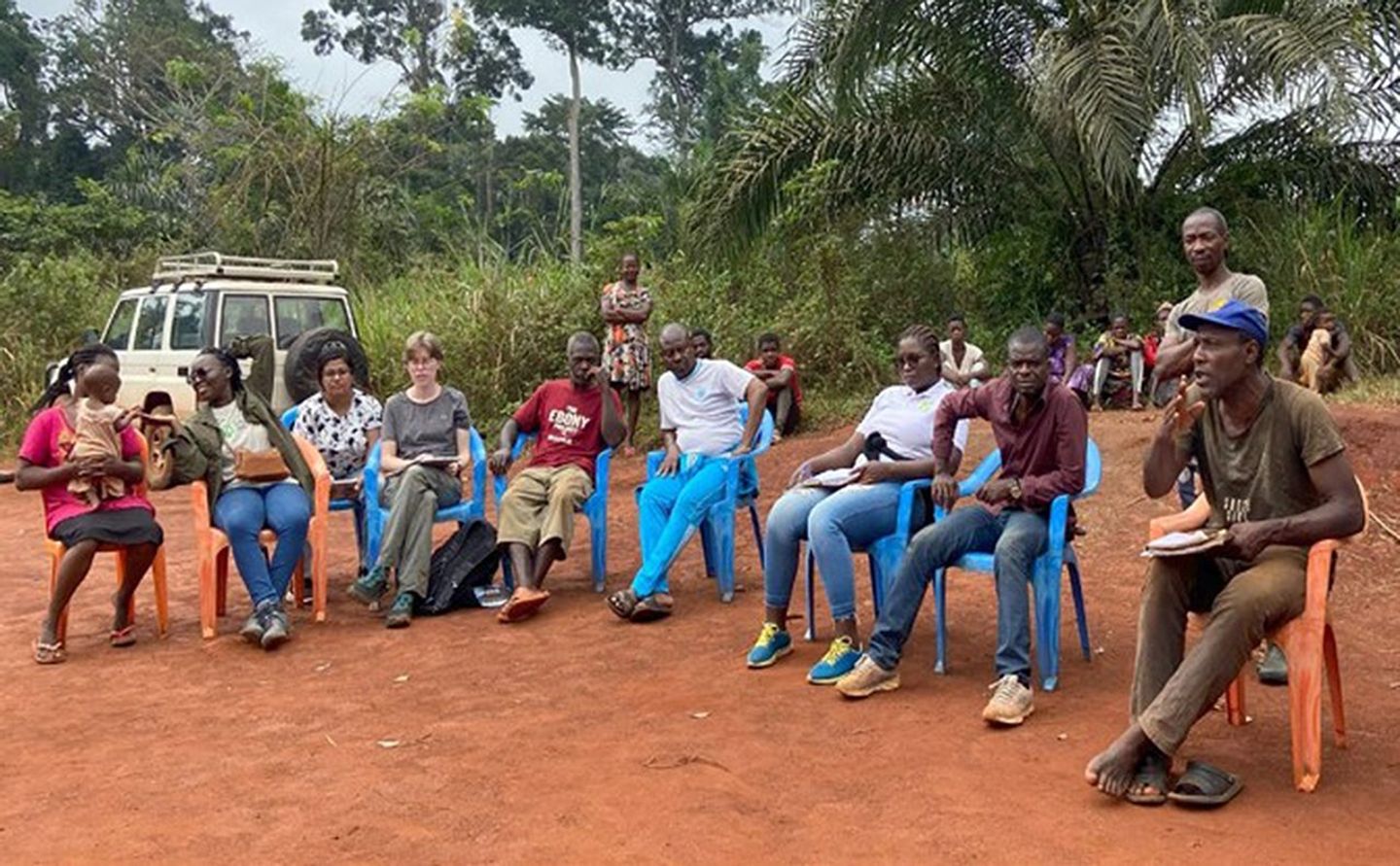
Elsa Ordway [University of California, Los Angeles (UCLA)] discussed her team’s efforts toward “Disentangling Land-Use Change in Central Africa to Understand the Role of Local and Indigenous Communities in Forest Restoration and Conservation.” Ordway reported that the project focuses on mapping land cover and carbon emissions, analyzing the impact of conservation efforts, and exploring potential forest restoration opportunities. She emphasized that this research highlights the critical role of local indigenous communities in forest management and the unintended consequences of conservation projects on land use – see Photo 2.
Photo 2. Some residents of a village neighboring the Dja reserve – part of the dense rain forests that form Africa’s Congo Basin. Interviews and surveys among the area’s local and indigenous communities are used to gather information on forest restoration and conservation.
Photo credit: Else Ordway (UCLA)
Ordway also presented on the PAN-tropical investigation of BioGeochemistry and Ecological Adaptation (PANGEA), which aims to investigate the biogeochemistry and ecological adaptation of tropical forests that are crucial for global climate regulation and biodiversity. She explained that this study emphasizes the rapid changes occurring in tropical regions primarily due to deforestation and climate change. PANGEA seeks to answer key scientific questions about the vulnerability and resilience of these ecosystems, and how this information can inform climate adaptation, mitigation, and biodiversity conservation efforts.
The ARID Experiment
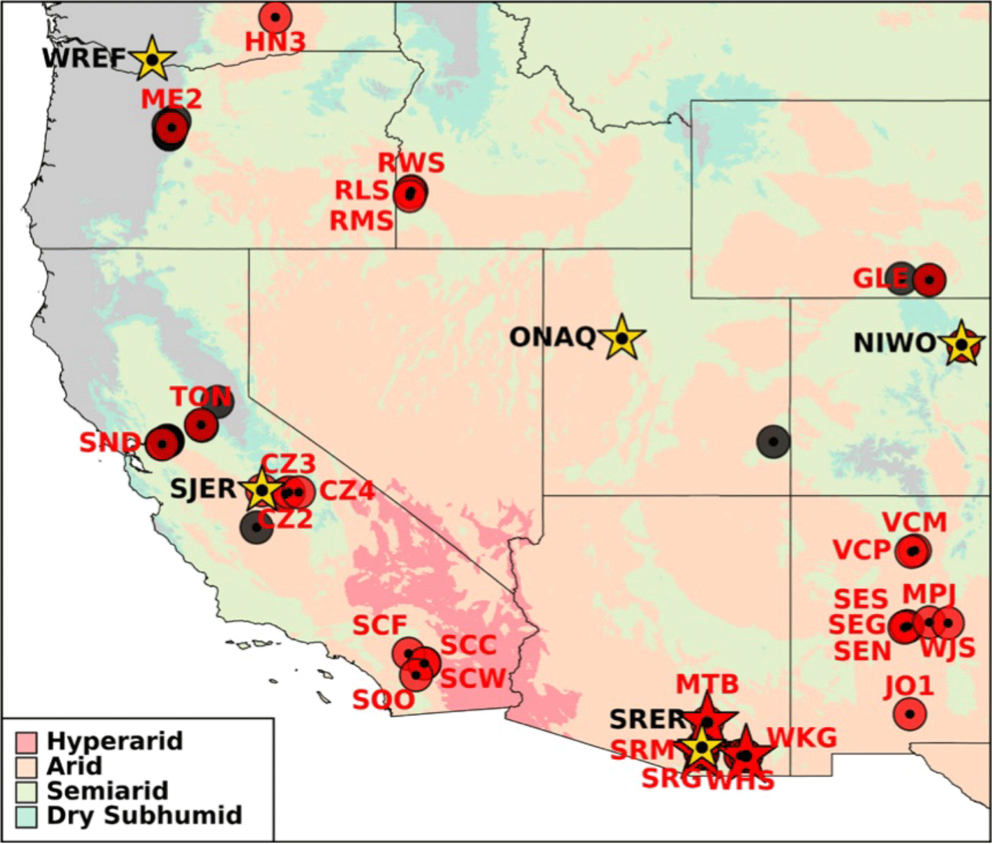
Andrew Feldman [NASA’s Goddard Space Flight Center (GSFC)] presented on the Adaptation and Response in Drylands (ARID) experiment, a field campaign focused on dryland ecosystems. He described how this project aims to understand the fundamental science of drylands, including water availability, land–atmosphere interactions, climate variability, carbon stocks, and land management. The study involves significant international collaboration and stakeholder engagement, with a particular focus on the Western U.S – see Figure 1. While this project is in planning stages, ongoing efforts will be made to engage with the scientific community, gather feedback, and refine its research themes.
Figure 1. The Adaptation and Response in Drylands (ARID) experiment focuses on studying the characteristics of dryland ecosystems, e.g., water availability, land–atmosphere interactions, climate variability, carbon stocks, and land management. While the experiment is global in scope, it has a focus on the Western U.S., with numerous site locations across the desert Southwest and some in the Pacific Northwest.
Figure credit: Andrew Feldman (NASA/UMD)
SARI Update and Related Projects
Krishna Vadrevu [NASA’s Marshall Space Flight Center] gave a comprehensive update on SARI, a regional initiative under the LCLUC program that addresses the critical needs of the South/Southeast Asia region by integrating remote sensing, natural sciences, engineering, and social sciences. His presentation covered the initiative’s background, various funded research projects, and their outputs. The diverse SARI projects include studies on forest degradation, agricultural transitions, food security, urbanization, and their environmental impacts. SARI has supported 35 research projects, engaging more than 400 scientists and over 200 institutions that result in significant scientific contributions, including nearly 450 publications, 16 special journal issues, and five books with two additional books pending publication. Vadrevu emphasized the importance of sustainable land use policies informed by LCLUC research and provided details on upcoming meetings. He concluded with information on three ongoing projects funded under the SARI synthesis solicitation – one in South Asia and two in Southeast Asia. Summaries of these projects are highlighted below.
David Skole [Michigan State University (MSU)] leads the SARI synthesis project that spans South Asian countries, with an emphasis on tree-based systems, particularly Trees Outside Forests (TOF). The primary objective is to synthesize existing research to better understand the patterns, drivers, and impacts of TOF on carbon emissions and removals and their role in supporting rural livelihoods. This research is crucial for informing climate change policy, particularly in the context of nature-based solutions and pathways to achieve net-zero emissions. The project combines empirical data with process-based research and policy models to support the development of sustainable landscapes. By integrating biophysical and socioeconomic data, the project team members aim to provide robust, evidence-based contributions to climate mitigation and adaptation strategies, ultimately guiding regional policy decisions.
Son Nghiem [NASA/Jet Propulsion Laboratory] discussed the interrelated dynamics of LCLUC and demographic changes in Southeast Asia under various developmental pressures and climate change. Nghiem explained that the study explores how these factors interact along the rural-to-urban continuum across regions in Cambodia, the Lao People’s Democratic Republic (Laos), Thailand, Vietnam, Malaysia, and parts of Indonesia. In rapidly urbanizing and agriculturally transitioning areas, physical and human feedback processes are becoming non-stationary, leading to unpredictable impacts that challenge traditional policymaking. The study aims to capture both physical patterns (e.g., land-use) and human (socioeconomic) fabrics, integrating these within a framework to assess whether the statistical properties of the time series measured during this study remain constant or change with time.
Peilei Fan [Tufts University] presented the project, “Decoding Land Transitions Across the Urban-Rural Continuums (URC): A Synthesis Study of Patterns, Drivers, and Socio-Environmental Impacts in Southeast Asia.” The project aims to synthesize knowledge through an interdisciplinary approach. It focuses on URCs in 19 cities across eight Southeast Asian countries. It investigates how global urban hierarchies, URC connectivity, and local policies influence land-use change and related ecosystem impacts. By integrating remote-sensing data with climate and ecological models and socioeconomic analysis, the project seeks to advance theoretical understanding of land transitions and provide valuable insights for both scientific research and policymaking.
The second day of the meeting continued with additional presentations from the LCLUC ROSES 2022 projects and updates from international programs. In addition, the attendees listened to presentations from NASA HQ and NASA Centers, describing various initiatives and data products, such as from the Socio-Economic Data and Applications Center (SEDAC).
Updates from LCLUC PIs on ROSES 2022 Proposal Selections (cont.)
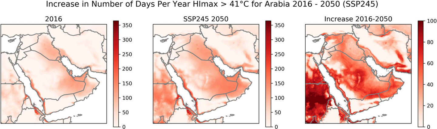
Cascade Tuholske [Montana State University] presented “Modulation of Climate Risks Due to Urban and Agricultural Land Uses in the Arabian Peninsula.” Tuholske explained how this project aims to map LCLUC, assess the effects on extreme humid heat, and characterize the socio-demographics of exposure to heat stress – see Figure 2. Key findings include evidence of a rapid increase in dangerously hot and humid weather – particularly in urban and agricultural areas – and the importance of remote sensing in studying these interactions. Future steps will involve using climate models to predict the effects of LCLUC on heat waves, water stress, and dust storms.
Figure 2. The Ghana Climate Hazards Center Coupled Model Intercomparison Project (CMIP) Phase 6 climate projection dataset map of temperatures exceeding 41 °C (106 °F) [left], future climate projection (SSP) for 2050 [middle], and the difference between the two [right].
Figure credit: From a 2024 paper in the journal Scientific Data
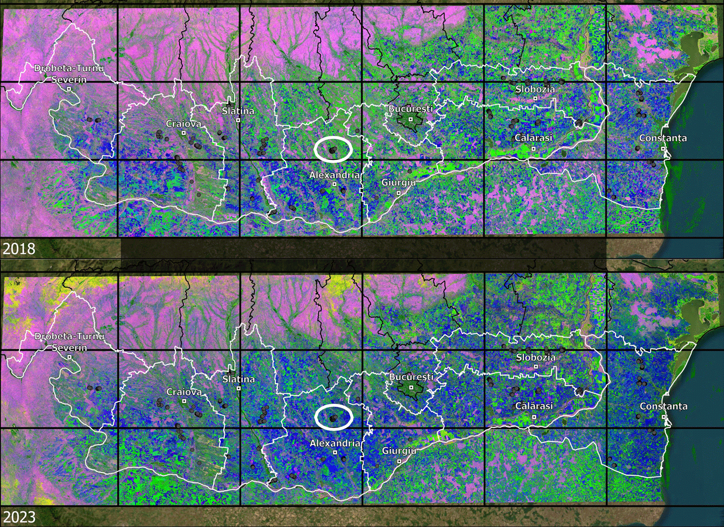
Monika Tomaszewska [MSU] provided details on the project, “Institutional Forcings on Agricultural Landscapes in Post-Socialist Europe: Diachronic Hotspot Analysis of Common Agricultural Policy Influences on Agricultural Land Use in Romania 2002–2024.” She explained that the project focuses on how the EU’s common agricultural policy (CAP) programs (e.g., livelihood payments, environmental protections, and rural development projects) have influenced land use changes – see Figure 3. Tomaszewska summarized key findings from the study, which indicates significant changes in crop composition and spatial patterns – with notable decreases in maize and rapeseed areas between 2018 and 2023. She stated that the study aims to understand the diffusion of innovation through CAP enrollments and payments and their impact on agricultural practices in Romania.
Figure 3. Dense time series of Harmonized Landsat Sentinel-2 (HLS) data at 30-m (98-ft) resolution revealing winter and summer crops across Southern Romania in 2018 [top] and 2023 [bottom]. Magenta areas indicate forests, green areas represent summer crops (e.g., maize, sunflower, soy), and blue areas show winter crops (e.g., wheat, barley, rapeseed). Yellow areas indicate very low spring Enhanced Vegetative Index-2 due to snow or persistent clouds at higher elevations.
Figure credit: Geoff Henebry (MSU)
Xiao-Peng Song [UMD] presented “Energy LCLUC Hotspot: Characterizing the Dynamics of Energy Land Use and Assessing Environmental Impacts in the Permian Basin.” He said that the project aims to assess the environmental impacts of energy-related land-cover and land-use change in the region. Song showed the output from the project, which includes high-resolution LCLUC and geohazard maps that enhance understanding of energy-related environmental impacts and contribute to NASA’s LCLUC program. Results from this study are expected to inform decision makers on societal issues related to oil and gas production and its effects on the environment.
International Partner Program Updates
The International Partners Programs session featured four presentations. Ariane DeBremond [UMD] focused on the Global Land Programme (GLP), which is a comprehensive, global initiative dedicated to understanding and addressing changes in land systems and their implications for sustainability and justice. DeBremond described the program, which coordinates research on land use, land management, and land cover changes,. She emphasized land systems as social-ecological systems and fostering interdisciplinary collaboration to develop solutions for global challenges. The research agenda includes descriptive, normative, and transformative aspects, aimed at characterizing land systems, identifying causes and impacts of changes, and creating pathways for sustainability transformations. GLP also emphasizes the need for new remote-sensing data, improved generalizability, and addressing geographic biases in land system science. Recent program activities include developing a new science plan, identifying emerging themes, and organizing open science meetings. DeBremond ended by announcing that the next GLP meeting is scheduled for November 2024 in Oaxaca, Mexico.
David Skole outlined the efforts of the Global Observations of Forest and Land Cover Dynamics (GOFC–GOLD) Land Implementation Team (LC–IT) in advancing methods and tools for global land cover measurements and monitoring. The LC–IT is primarily focused on developing and evaluating space-borne and in-situ observation techniques to support global change research, forest inventories, and international policy. Skole highlighted the importance of regional networks in coordinating the use of Earth Observation (EO) data, facilitating capacity building, and addressing regional concerns through workshops and partnerships. He also discussed the changing role of EO in responding to climate change and sustainability challenges, emphasizing the need for high-integrity carbon finance and the integration of new data and technologies to support nature-based solutions. He concluded with insights into the BeZero Carbon Rating system, which evaluates carbon efficacy across various projects worldwide and highlights the need for reliable ratings to ensure the credibility of carbon markets.
David Roy [MSU] detailed the work of the GOFC-GOLD Fire Implementation Team, which focuses on improving the accuracy and utility of satellite-based fire monitoring. The team is working to enhance global fire observation requirements, particularly for small fires and those with low Fire Radiative Power, which are often underrepresented in current datasets. Roy emphasized the need for continuous development and validation of satellite-derived fire products, including a robust quality assurance framework. The team advocates for standardized methods to validate fire data and harmonize information from various satellite missions to create a more comprehensive global fire record. Roy also highlighted the need for new satellite missions with advanced fire detection capabilities and the use of machine learning to improve fire modeling and data accessibility to provide more accurate and actionable data for global change research and fire management.
Alexandra Tyukavina [UMD] presented on Land Product Validation (LPV) subgroup of the Committee on Earth Observation Satellites (CEOS) Working Group on Calibration and Validation (WGCV). The LPV is focused on updating land cover validation guidelines, incorporating new literature and data from the past 20 years. Tyukavina emphasized the need for rigorous accuracy assessment in land cover studies, highlighting the need to improve methods and reporting as well as accuracy. She also discussed the outcomes of a NASA-sponsored joint cropland validation workshop co-hosted by CEOS and GEOGLAM, which aimed to set minimum requirements for cropland validation and develop community guidelines. Tyukavina concluded her presentation with a call for reviewers to assist in updating these guidelines.
LCLUC Program Crosswalks
The Crosswalks, a LCLUC program, featured six presentations. Frederick Policelli [GSFC] presented on the CSDA program, which supports the ESD by acquiring and utilizing commercial, small-satellite data to enhance Earth science research. Launched as a pilot in November 2017, the program became a sustained effort in 2020, transitioning from Blanket Purchase Agreements to Indefinite-Delivery, Indefinite-Quantity contracts for better data management. The CSDA also introduced a tiered End User License Agreement for data usage and focuses on long-term data preservation and broad access. Policelli described how program participants collaborate with U.S. government agencies and international partners, adhering to the 2003 U.S. Commercial Remote Sensing Policy. He discussed recent developments, which include onboarding new commercial data vendors and expanding the program’s capabilities.
Jacqueline Le Moigne [ESTO] provided details on NASA’s Earth Science Technology Office’s (ESTO), Advanced Information Systems Technology (AIST) program and its development of Earth System Digital Twins (ESDT). She explained that ESDTs are intended to be dynamic, interactive systems that replicate the Earth’s past and current states, forecast future states, and assess hypothetical scenarios. They should integrate continuous data from diverse sources, utilize advanced computational and visualization capabilities, and rely heavily on machine learning for data fusion, super-resolution, and causal reasoning. Le Moigne added that ESDTs enhance our understanding of Earth systems, their interactions, and applications, particularly in the context of climate change. She highlighted various use cases (e.g., wildfires, ocean carbon processes, the water cycle, and coastal zones) demonstrating the potential of ESDTs to support decision-making and policy planning.
Roger Pielke [University of Colorado, Boulder] discussed the critical need to incorporate land-use data into weather forecasts and climate models to improve understanding of and address climate change. He emphasized the distinction between weather and climate, explaining that climate is dynamic and influenced by both natural and human factors. Pielke critiqued the focus of the approach of the Intergovernmental Panel on Climate Change (IPCC) on carbon dioxide (CO2) emissions as the primary driver of climate change, arguing that LCLUC should be considered as an equally important climate forcing. He illustrated how changes in land cover, such as in Florida and the Great Plains, can significantly impact local and regional climate, sometimes rivaling the effects of CO2. Pielke called for integrating land-use data into climate models across all scales, suggesting that NASA’s programs could lead in this effort to enhance climate forecasting and policymaking.
Brad Doorn [NASA HQ—Program Manager, NASA’s Earth Action Agriculture Program] presented an overview of the program’s status and strategic direction. He emphasized the importance of partnerships, particularly with the USDA, in advancing initiatives like Climate Smart Agriculture. NASA’s role in global food security and supply chain monitoring was highlighted through the activities of NASA’s Harvest and Acres, agriculture and food security consortia, both of which enable collaborative research to codevelop data-driven products and services and enhance predictive models to meet end-user needs. Doorn stressed the need for strong collaborations with the private sector, non-governmental organizations, and other space agencies to accelerate the development of agricultural solutions. He also highlighted the significance of integrating NASA’s capabilities in weather, water, and crop monitoring systems to provide comprehensive tools for stakeholders. Doorn explained that the program aims to bridge gaps between NASA’s observations and practical applications in agriculture, leveraging tools, such as the Global Crop Monitor, and integrating predictive capabilities for improved future planning.
Rachel Paseka [NASA HQ] presented on NASA’s open science funding opportunities with a focus on the ROSES F.7 element, which supports widely used open-source software tools, frameworks, and libraries within the NASA science community. She described the program, which offers two types of awards: Foundational Awards for projects that impact multiple divisions and Sustainment Awards for those affecting one or more divisions of the Science Mission Directorate. Foundational Awards are cooperative agreements lasting up to five years. Sustainment Awards can be grants or cooperative agreements lasting up to three years. Paseka also emphasized the importance of open science, highlighting various tools, data challenges, and collaborative efforts, including artificial intelligence (AI) models for tasks (e.g., flood detection and burn scar mapping). She concluded with an introduction of the Science Explorer (SciX) digital library and the Science Discovery Engine, both of which facilitate access to NASA’s open science data and research.
Alex de Sherbinin [SocioEconomic Data and Applications Center (SEDAC), Center for InternationalEarth Science Information Network (CIESIN), Columbia University] provided an overview of datasets and research related to climate risk, social vulnerability, and environmental change. de Sherbinin outlined the SocioEconomic Data and Applications Center (SEDAC) mission areas, which include population land-use and emissions, mitigation, vulnerability and adaptation, hazard vulnerability assessment, poverty and food security, and environment and sustainable development. He highlighted key SEDAC datasets (e.g., LCLUC and Urban and Settlements Datasets) and their use in analyses. SEDAC data and services are accessible via tools, such as Global Forest Watch and Google Earth Engine. de Sherbinin also covered recent research citations, the impact of studies on biodiversity and urban changes, and SEDAC’s contributions to open science and training initiatives. He also emphasized the importance of integrating remote sensing data with social and health sciences for comprehensive environmental analysis.
DAY THREE
The third day of the meeting focused on satellite missions and data product updates and a LCLUC program feedback session on emerging science directions.
Landsat Mission Updates
Chris Neigh [GSFC—Landsat 9 Project Scientist] provided an overview of the status of the current Landsat missions that are in orbit (L7, L8, and L9]. He reported that all L9 Level-1 requirements have now been met and exceeded. OLI-2, the updated sensor for L9, transmits data at 14 bits compared to the L8 12-bit transmission, allowing for finer data resolution. OLI-2 offers a 25–30% improvement in the signal-to-noise ratio for dark targets, leading to enhanced data quality. The Thermal Infrared Sensor on L9 (TIRS-2) has also been improved over TIRS on L7 and L8, to mitigate stray light issues, enhancing the reliability of thermal data. Additionally, OLI-2 supports better atmospheric corrections through split window techniques using both of its channels. With two operational observatories, L8 and L9, equipped with advanced radiometry, data is provided every eight days, ensuring consistent and precise Earth observation capabilities. The radiometric and geometric performance of L9 is excellent from a Calibration/Validation (Cal/Val) perspective.
While all systems are nominal for L8 and L9, Neigh reported that L7 is nearing the end of its operational life. He stated that the Landsat Cal/Val team will continue its work for the duration of the mission as a joint USGS–NASA effort. He also highlighted the need for a global Analysis Ready Data framework and the development of proxy and simulated datasets to support the next generation of Landsat missions. Neigh ended by reporting that opportunities exist for scientists to share their high-profile, Landsat-based research through the program’s communications team.
Bruce Cook [GSFC—Landsat Next Project Scientist] provided an update on the Landsat Next mission, an ambitious extension of the Landsat Program under the Sustainable Land Imaging (SLI) program, which will be a joint effort by NASA and the USGS. Cook explained that this mission aims to greatly enhance Earth observation by launching three identical satellites, each equipped with advanced Visible Shortwave Infrared (VSWIR) and Thermal Infrared (TIR) instruments. He described how the Landsat Next constellation will improve the temporal revisit time to six days – a major advancement from the 16-day interval of L8 and L9. In order to achieve this revisit time improvement, each satellite will carry a Landsat Next Instrument Suite (LandIS) that will capture 21 VSWIR and five thermal infrared bands, which will have better spatial resolutions compared to previous Landsat missions. It will have ground sample distances of 10–20 m (33–66 ft) for visible, near infrared, and shortwave infrared bands and 60 m (197 ft) for atmospheric visible SWIR and thermal infrared bands.
Cook continued with details on LandIS, stating that Landsat Next will record 26 bands in total – 15 more than the currently active L8 and L9 missions. The LandIS will include refined versions of the 11 Landsat “heritage” bands to ensure continuity, five new bands similar to the ESA’s Copernicus Sentinel-2 mission for improved data integration, and 10 new spectral bands to meet evolving user needs and applications. Additionally, Landsat Next will have a water vapor band for atmospheric correction without needing data from other satellites. LandIS will collect all bands nearly simultaneously, reducing illumination variations between bands and aiding in cloud detection and the generation of multispectral surface reflectance and thermal emission products (e.g., evapotranspiration).
Cook said that Landsat Next is in Phase A of its mission life cycle. The current focus is on defining science requirements and converting them into specific hardware and system designs. He said that this phase is crucial for setting up the subsequent phases. Phase B will involve preliminary design and technology completion, and later phases leading to the final design, fabrication, and launch of the satellites. He ended by emphasizing that the introduction of a new reference system and a lower orbit will further enhance the satellites’ ability to capture high-quality data, leading to a significant advancement in Earth observation technology.
Harmonized Landsat–Sentinel Project Update
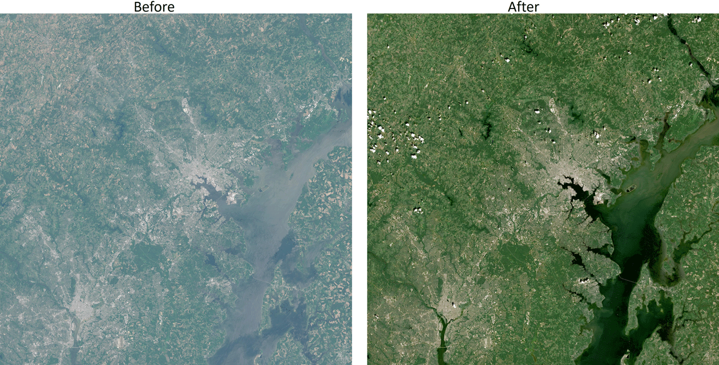
Junchang Ju [GSFC] discussed the Harmonized Landsat Sentinel-2 (HLS) project, which aims to integrate data from the L8, L9, Sentinel-2A, and Sentinel-2B satellites for more frequent and detailed Earth observations. Currently the MODIS climate modeling grid data is used for atmospheric correction – see Figure 4. The newer HLS version will use VIIRS-based water vapor and ozone fields instead of MODIS data for atmospheric correction using the land surface reflectance code. Ju explained how HLS adopts the Military Grid Reference System used by Sentinel-2. HLS V2.0 corrects a mistake in view angle normalization of earlier versions (V1.3 and V1.4). Atmospherically corrected data from Hyperion (an instrument on NASA’s Earth Observing–1 extended mission) is used to make bandpass adjustments. A temporally complete global HLS V2.0 dataset has been available since August 2023. He also highlighted the availability and access of HLS data through various platforms – e.g., EarthData and WorldView, in Amazon Web Services and the project’s future plans, such as enhancing vegetation indices, cloud mask improvements, and 10-m (33-ft) improved resolution product.
Figure 4. Sentinel-2B image over the Baltimore-Washington area on April 7, 2022 [left]. Example true color images of top of atmospheric reflectance and the corresponding HLS surface reflectance are shown [right]. The atmospheric ancillary data used in the surface reflectance derivation was from the MODIS Climate Modeling Grid (CMG) data before the transition to VIIRS was implemented.
Figure Credit: Junchang Ju (GSFC)
NISAR Update
Gerald Bawden [NASA HQ—NISARProgram Scientist] delivered a presentation about the NISAR mission, which is a collaborative effort between NASA and the ISRO. He explained that NISAR will be a dual-frequency Synthetic Aperture Radar satellite using 24-cm (9-in) L-band and 10-cm (4-in) S-band radar frequencies. This dual-frequency approach will enable high-resolution imaging of Earth’s surface, offering near-global land and ice coverage with a 12-day repeat cycle for interferometry and approximately 6-day coverage using both ascending and descending orbits. The mission’s goals include providing valuable data to understand and manage climate variability, carbon dynamics, and catastrophic events (e.g., earthquakes). Specific applications include monitoring deformation, measuring ice sheet velocities, observing sea-ice deformation, and assessing biomass and crop disturbances. Bawden discussed NISAR’s data products, which will include raw radar data (Level-0) and geocoded single-look complex images and multi-look interferograms (Level-2). He stated that these data products will be crucial for various research and practical applications, including ecological forecasting, wildfire management, resource management, and disaster response. NISAR’s data will be openly accessible to the global scientific community through the Alaska Satellite Facility Data Active Archive Center. Initially planned for early 2024, the NISAR launch has been delayed to 2025. Bawden reported that NISAR will undergo a three-month commissioning phase after launch – before starting science operations. He also emphasized NASA’s commitment to open science, with NISAR’s data processing software and algorithms being made available as open-source tools, accompanied by training resources to facilitate their use.
Land Surface Disturbance Alert Classification System Update
Matthew Hansen [UMD] focused on the Land Surface Disturbance Alert (DIST-ALERT) classification system, designed for near-real-time global vegetation extent and loss mapping. He described the DIST-ALERT system, which uses HLS data, combining inputs from L8, L9, Sentinel-2A, and -2B to achieve a high-revisit rate of approximately 2–3 days at a 30-m (98-ft) resolution. DIST-ALERT operates with a primary algorithm that tracks vegetation loss through time-series analysis of fractional vegetation cover (FVC) and a secondary algorithm that detects general spectral anomalies. The system integrates drone data from various biomes to build a k-nearest neighbors model that is applied globally to predict FVC at the HLS-pixel scale. Hansen explained that DIST-ALERT monitors disturbances by comparing current vegetation fraction against a seasonal baseline, capturing changes such as forest fires, logging, mining, urban expansion, drought, and land conversion. He concluded by highlighting some case studies, including analysis of forest fires in Quebec, Canada, logging in the Republic of Congo, and gold mining in Ghana. He also said that the team released an improved version (V1) in March 2024, following a provisional release (V0) that was operational from February 2023 to February 2024.
State of LCLUC Report
Chris Justice [UMD—LCLUC Program Scientist] provided comments on the current state of the LCLUC program, followed by an open discussion to gather feedback. He emphasized the need for PI’s to effectively communicate their work to the broader community and highlighted the recent LCLUC initiative to create policy-oriented briefs based on research results, demonstrating its relevance to the Earth Science to Action Strategy. Justice acknowledged that challenges lie ahead for the LCLUC program – particularly considering the anticipated resource constraints in the coming year. He noted that the program plans to strengthen its position by forming partnerships with other ESD program elements and increasing involvement across NASA Centers. The program is also emphasizing the use of advanced remote sensing technologies, AI, and deep-learning data analytics, to deliver more precise and actionable insights into land dynamics contributing to better decision-making and policy development in land management and environmental conservation.
Justice also suggested the need for better integration between different scientific fields (i.e., between LCLUC and climatology, climate mitigation, and adaptation) to enhance interdisciplinary research and collaboration. He cited the current program solicitation (e.g., ROSES 2024 A.2) as an example of this integration and the recent IDS solicitation in ROSES 2022 A.28. Justice reminded participants that the solicitation focuses on collaborating with AIST to develop Land Digital Twins that incorporate available remote sensing data time series as non-static boundary conditions in weather forecast and climate models. Improvements in model forecasts and climate simulations will highlight the importance of accounting for LCLUC in these models – advancing the goals of the IPCC.
Conclusion
Garik Gutman concluded the meeting by summarizing key points raised about data management strategies, educational outreach efforts, LCLUC research outside the U.S., and current and upcoming projects. He highlighted that the program requires PIs to provide metadata for data products generated under NASA-funded projects, ensuring these resources are freely and openly accessible to the scientific community. Gutman acknowledged the challenges of conducting research and fieldwork in foreign countries due to funding and, at times, security issues, but praised the PIs for their efforts to expand the program globally. He also noted the program’s outreach efforts, which include engaging PIs, collaborators, and interested parties through its website, newsletters, webinars, and policy briefs. LCLUC emphasizes the importance of effectively communicating research results and encourages researchers to share their findings via NASA’s Earth Sciences Research Results Portal to enhance visibility among leadership and communication teams.
Gutman ended his presentation by providing details about forthcoming meetings in the Philippines, South Korea, and Turkey, as well as workshops scheduled for 2024, which will involve various stakeholders in the LCLUC community and are vital for fostering collaboration and advancing the program’s goals. He concluded by recognizing the contributions of long-term supporters and collaborators, reaffirming the program’s ongoing commitment to advancing Earth observation and land-use science.
Overall, the 2024 LCLUC meeting was highly successful in fostering collaboration among researchers and providing valuable updates on recent developments in LCLUC research. The exchange of ideas, integration of new data products, and discussions on emerging science directions were particularly impactful, contributing to the advancement of the LCLUC program’s goals.
Krishna Vadrevu NASA’s Marshall Space Flight Center krishna.p.vadrevu@nasa.gov
Meghavi Prashnani University of Maryland, College Park meghavi@umd.edu
Christopher Justice University of Maryland, College Park cjustice@umd.edu
Members of the Elsevier-published Journal of Human Evolution quit, citing AI production processes introducing errors, high author fees, and concerns over editorial independence.