Preparations for Next Moonwalk Simulations Underway (and Underwater)
The Compact Fire Infrared Radiance Spectral tracker, or C-FIRST, is managed an operated by NASA’s Jet Propulsion Laboratory, and supported by NASA’s Earth Science Technology Office. Combining state-of-the-art imaging technology with a compact design, C-FIRST enables scientists to gather data about fires and their impacts on ecosystems with greater accuracy and speed than other instruments. C-FIRST was developed as a spaceborne instrument, and flew onboard NASA’s B200 aircraft in January 2025 to conduct an airborne test.
NASA/JPL-Caltech
The January wildfires in California devastated local habitats and communities. In an effort to better understand wildfire behavior, NASA scientists and engineers tried to learn from the events by testing new technology.
The new instrument, the Compact Fire Infrared Radiance Spectral Tracker (c-FIRST), was tested when NASA’s B200 King Air aircraft flew over the wildfires in the Pacific Palisades and Altadena, California. Based at NASA’s Armstrong Flight Research Center in Edwards, California, the aircraft used the c-FIRST instrument to observe the impacts of the fires in near real-time. Due to its small size and ability to efficiently simulate a satellite-based mission, the B200 King Air is uniquely suited for testing c-FIRST.
Managed and operated by NASA’s Jet Propulsion Laboratory in Southern California, c-FIRST gathers thermal infrared images in high-resolution and other data about the terrain to study the impacts of wildfires on ecology. In a single observation, c-FIRST can capture the full temperature range across a wide area of wildland fires – as well as the cool, unburned background – potentially increasing both the quantity and quality of science data produced.
“Currently, no instrument is able to cover the entire range of attributes for fires present in the Earth system,” said Sarath Gunapala, principal investigator for c-FIRST at NASA JPL. “This leads to gaps in our understanding of how many fires occur, and of crucial characteristics like size and temperature.”
For decades, the quality of infrared images has struggled to convey the nuances of high-temperature surfaces above 1,000 degrees Fahrenheit (550 degrees Celsius). Blurry resolution and light saturation of infrared images has inhibited scientists’ understanding of an extremely hot terrain, and thereby also inhibited wildfire research. Historically, images of extremely hot targets often lacked the detail scientists need to understand the range of a fire’s impacts on an ecosystem.
NASA’s Armstrong Flight Research Center in Edwards, California, flew the B200 King Air in support of the Signals of Opportunity Synthetic Aperture Radar (SoOpSAR) campaign on Feb. 27, 2023.
NASA/Steve Freeman
To address this, NASA’s Earth Science Technology Office supported JPL’s development of the c-FIRST instrument, combining state-of-the-art imaging technology with a compact and efficient design. When c-FIRST was airborne, scientists could detect smoldering fires more accurately and quickly, while also gathering important information on active fires in near real-time.
“These smoldering fires can flame up if the wind picks up again,” said Gunapala. “Therefore, the c-FIRST data set could provide very important information for firefighting agencies to fight fires more effectively.”
For instance, c-FIRST data can help scientists estimate the likelihood of a fire spreading in a certain landscape, allowing officials to more effectively monitor smoldering fires and track how fires evolve. Furthermore, c-FIRST can collect detailed data that can enable scientists to understand how an ecosystem may recover from fire events.
“The requirements of the c-FIRST instrument meet the flight profile of the King Air,” said KC Sujan, operations engineer for the B200 King Air. “The c-FIRST team wanted a quick integration, the flight speed in the range 130 and 140 knots on a level flight, communication and navigation systems, and the instruments power requirement that are perfectly fit for King Air’s capability.”
By first testing the instrument onboard the B200 King Air, the c-FIRST team can evaluate its readiness for future satellite missions investigating wildfires. On a changing planet where wildfires are increasingly common, instruments like c-FIRST could provide data that can aid firefighting agencies to fight fires more effectively, and to understand the ecosystemic impacts of extreme weather events.
The 2024 Annual Highlights of Results from the International Space Station is now available. This new edition contains updated bibliometric analyses, a list of all the publications documented in fiscal year 2024, and synopses of the most recent and recognized scientific findings from investigations conducted on the space station. These investigations are sponsored by NASA and all international partners – CSA (Canadian Space Agency), ESA (European Space Agency), JAXA (Japan Aerospace Exploration Agency), and the State Space Corporation Roscosmos (Roscosmos) – for the advancement of science, technology, and education.
Dr. Dmitry Oleynikov remotely operates a surgical robot aboard the Space Station using controls at the Virtual Incision offices in Lincoln, Nebraska. Robotic Surgery Tech Demo tests techniques for performing a simulated surgical procedure in microgravity using a miniature surgical robot that can be remotely controlled from Earth.
Credits: University of Nebraska-Lincoln
Between Oct. 1, 2023, and Sept. 30, 2024, more than 350 publications were reported. With approximately 40% of the research produced in collaboration between more than two countries and almost 80% of the high-impact studies published in the past seven years, station has continued to generate compelling and influential science above national and global standards since 2010.
The results achieved from station research provide insights that advance the commercialization of space and benefit humankind.
Some of the findings presented in this edition include:
Improved machine learning algorithms to detect space debris (Italian Space Agency, Roscosmos, ESA)
Maintained function of cardiac 3D stem cellsafter weeks of exposure to space (NASA)
The content in the Annual Highlights of Results from the International Space Station has been reviewed and approved by the International Space Station Program Science Forum, a team of scientists and administrators representing NASA and international partners that are dedicated to planning, improving, and communicating the research operated on the space station.
[See the list of Station Research Results publications here and find the current edition of the Annual Highlights of Results here.]
Researchers report detailed physical properties of different types of corona discharges, including single- and multi-pulse blue discharges linked to powerful but short-lived electrical bursts near the tops of clouds. These details provide a reference for further investigation into the physical mechanisms behind these discharges and their role in the initiation of lightning, an important problem in lightning physics.
An ESA (European Space Agency) instrument used to study thunderstorms, Atmosphere-Space Interactions Monitor (ASIM) provides insights into their role in Earth’s atmosphere and climate, including mechanisms behind the creation of lightning. Understanding how thunderstorms and lightning disturb the upper atmosphere could improve atmospheric models along with climate and weather predictions. These high-altitude discharges also affect aircraft and spacecraft safety.
An artist’s impression of a blue jet as observed from the International Space Station.
Mount Visual/University of Bergen/DTU Space
Evaluating effects of climate change on oceans
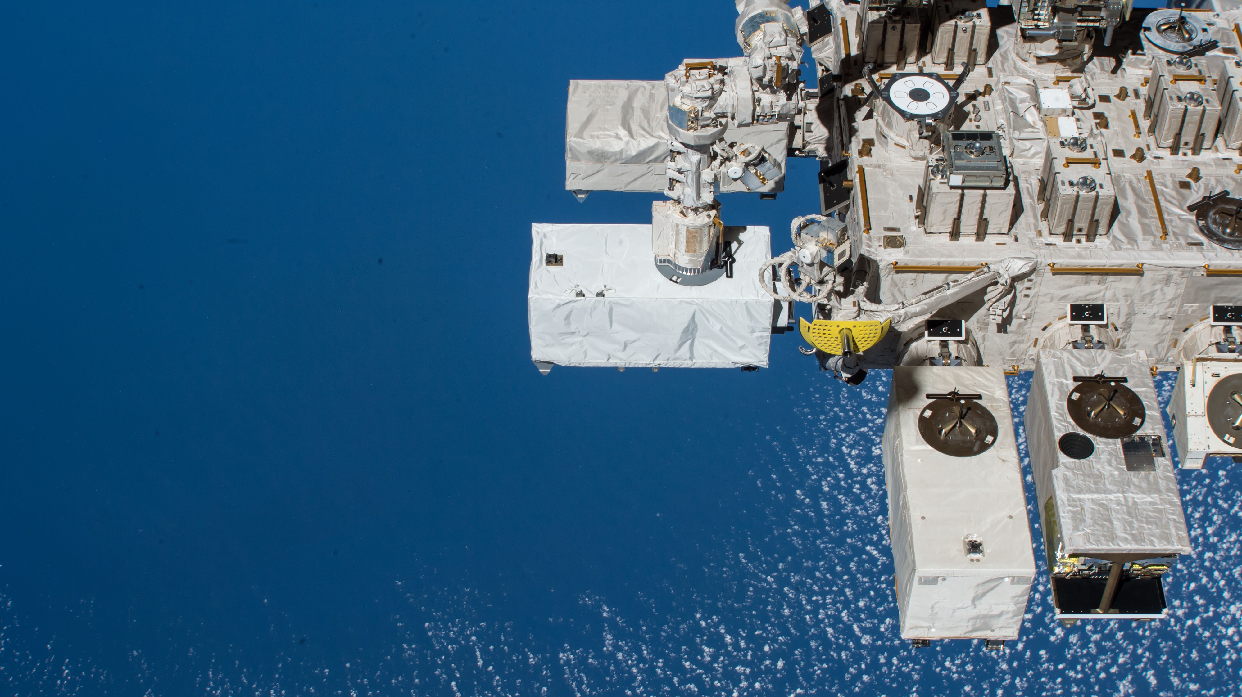
Researchers conclude that the space station’s ECOSTRESS instrument yields highly accurate sea surface temperature data. Given the instrument’s global coverage and high spatial resolution, these data have potential use in studies of biological and physical oceanography to evaluate regional and local effects of climate change.
ECOSTRESS resolves oceanographic features not detectable in imagery from NOAA’s Visible Infrared Imaging Radiometer Suite satellite, and has open-ocean coverage, unlike Landsat. Satellites are a fundamental tool to measure sea surface temperatures, which are rising across all oceans due to atmospheric warming induced by climate change.
The ECOSTRESS instrument, the white box in the center, is visible on the outside of the station.
NASA
Describing a gamma ray burst
Researchers report detailed observations and analysis of emissions from an exceptionally bright gamma ray burst (GRB), 210619B, detected by the station’s ASIM and other satellite and ground-based instruments. These observations could be useful in determining various properties of GRBs and how they change during different phases.
Believed to be generated by the collapse of massive stars, GRBs are the brightest, most explosive transient electromagnetic events in the universe. ASIM can observe thunderstorm discharges difficult to observe from the ground. It has a mode where a detected event triggers observation and onboard storage of data.
A view of ASIM mounted on the outside of the space station.
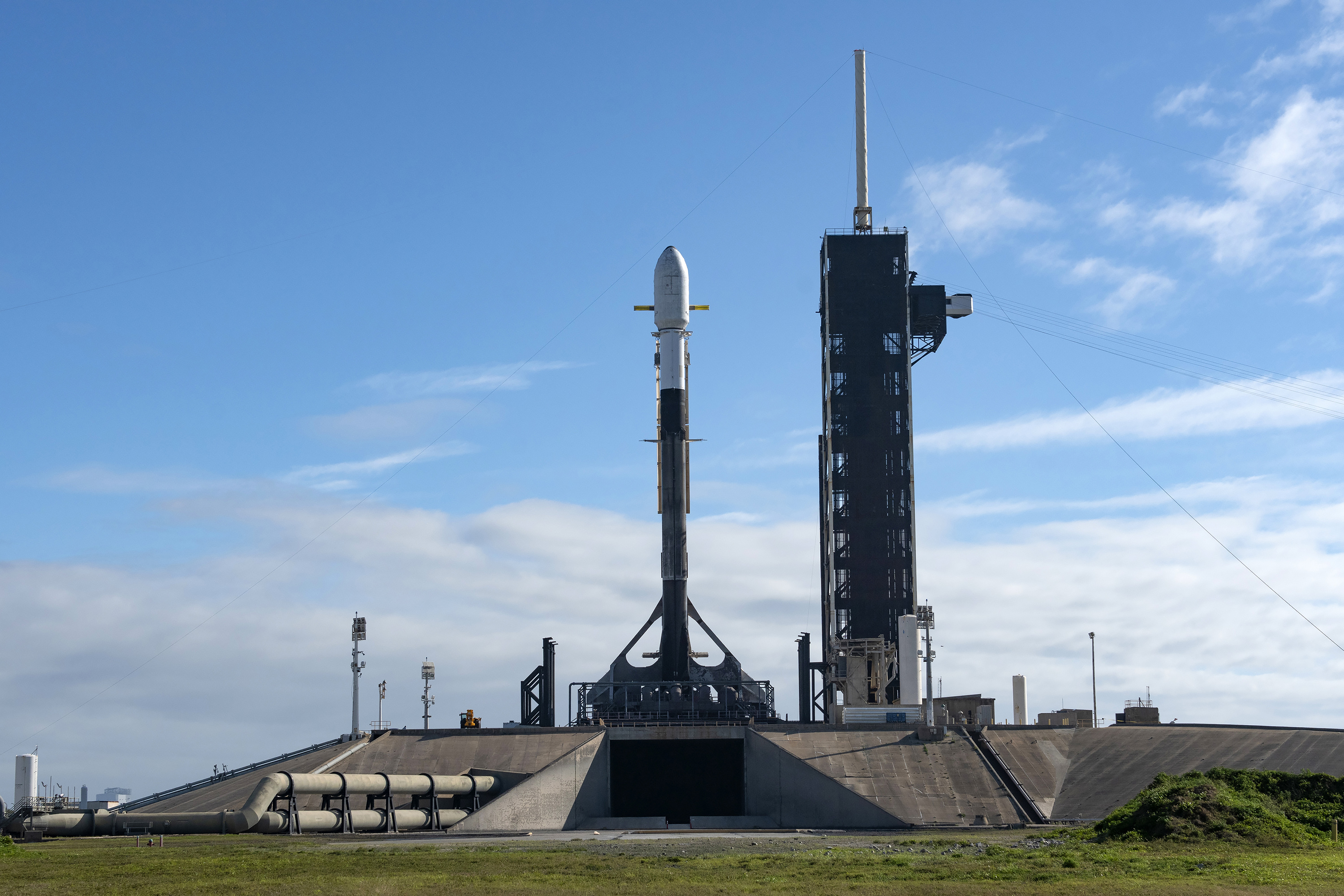
A SpaceX Falcon 9 rocket stands vertical on Tuesday, Feb. 25, 2025, at Launch Complex 39A at NASA’s Kennedy Space Center ahead of Intuitive Machines’ IM-2 mission as part of the agency’s Commercial Lunar Payload Services initiative and Artemis campaign.
SpaceX
Sending instruments to the Moon supports a growing lunar economy on and off Earth, and the next flight of NASA science and technology is only days away. NASA’s CLPS (Commercial Lunar Payload Services) initiative is a lunar delivery service that sends NASA science and technology instruments to various geographic locations on the Moon using American companies. These rapid, cost-effective commercial lunar missions at a cadence of about two per year improve our understanding of the lunar environment in advance of future crewed missions to the Moon as part of the agency’s broader Artemis campaign.
Of the 11 active CLPS contracts, there have been three CLPS launches to date: Astrobotic’s Peregrine Mission One, which collected data in transit but experienced an anomaly that prevented it from landing on the Moon; Intuitive Machines’ IM-1 mission, which landed, tipped over, and operated on the lunar surface; and Firefly Aerospace’s Blue Ghost Mission One that is currently enroute and scheduled to land in early March 2025. The CLPS contract awards cover end-to-end commercial payload delivery services, including payload integration, launch from Earth, landing on the surface of the Moon, and mission operations.
NASA’s fourth CLPS flight is from Intuitive Machines with their IM-2 mission. The IM-2 mission is carrying NASA science and technology instruments to Mons Mouton, a lunar plateau just outside of 5 degrees of the South Pole of the Moon, closer to the pole than any preceding lunar mission.
Scheduled to launch no earlier than Wednesday and land approximately eight days later, Intuitive Machines’ Nova-C lander, named Athena, will carry three NASA instruments to the lunar South Pole region – the Polar Resources Ice Mining Experiment-1 (PRIME-1) suite and the Laser Retroreflector Array (LRA).
The PRIME-1 suite consists of two instruments, the TRIDENT drill (The Regolith Ice Drill for Exploring New Terrain) and MSolo (Mass Spectrometer observing lunar operations), which will work together to extricate lunar soil samples, known as regolith, from the subsurface and analyze their composition to further understand the lunar environment and gain insight on potential resources that can be extracted for future examination.
The meter-long TRIDENT drill is designed to extract lunar regolith, up to about three feet below the surface. It will also measure soil temperature at varying depths below the surface, which will help to verify existing lunar thermal models that are used for ice stability calculations and resource mapping. By drilling into the lunar regolith, information is gathered to help answer questions about the lunar regolith geotechnical properties, such as soil strength, both at the surface and in the subsurface that will help inform Artemis infrastructure objectives. The data will be beneficial when designing future systems for on-site resource utilization that will use local resources to create everything from landing pads to rocket fuel. The lead development organization for TRIDENT is Honeybee Robotics, a Blue Origin Company.
The MSOLO instrument is a mass spectrometer capable of identifying and quantifying volatiles (or gasses that easily evaporate) found at or beneath the lunar surface, including– if it’s present in the regolith within the drill’s reach – water and oxygen, brought to the surface by the TRIDENT drill. This instrument can also detect any gases that emanate from the lander, drilling process, and other payloads conducting operations on the surface. Using MSolo to study the volatile gases found on the Moon can help us understand how the lander’s presence might alter the local environment. The lead development organization is INFICON of Syracuse, New York, in partnership with NASA’s Kennedy Space Center in Florida.
NASA’s LRA is a collection of eight retroreflectors that enable precision laser ranging, which is a measurement of the distance between the orbiting or landing spacecraft to the reflector on the lander. The LRA instrument is passive, meaning it does not power on. It will function as a permanent location marker on the Moon for decades to come, similar to its predecessors. The lead development organization is NASA’s Goddard Space Flight Center in Greenbelt, Maryland.
In addition to the CLPS instruments, two technology demonstrations aboard IM-2 were developed through NASA’s Tipping Point opportunity. These are collaborations with the agency’s Space Technology Mission Directorate and industry that support development of commercial space capabilities and benefit future NASA missions.
Intuitive Machinesdeveloped a small hopping robot, Grace, named after Grace Hopper, computer scientist and mathematician. Grace will deploy as a secondary payload from the lander and enable high-resolution imaging and science surveying of the lunar surface, including permanently shadowed craters around the landing site. Grace is designed to bypass obstacles such as steep inclines, boulders, and craters to cover a lot of terrain while moving quickly, which is a valuable capability to support future missions on the Moon and other planets, including Mars.
Nokiawill test a Lunar Surface Communications System that employs the same cellular technology here on Earth. Reconceptualized by Nokia Bell Labs to meet the unique requirements of a lunar mission, this tipping point technology aims to demonstrate proximity communications between the lander, a Lunar Outpost rover, and the hopper.
Launching as a rideshare alongside the IM-2 mission, NASA’s Lunar Trailblazer spacecraft also will begin its journey to lunar orbit where it will map the distribution of water – and other forms of water – on the Moon.
Future CLPS flights will continue to send payloads to the near side, far side, and South Pole regions of the Moon where investigations and exploration are informed by each area’s unique characteristics. With a pool of 13 American companies under CLPS, including a portfolio of 11 lunar deliveries by five vendors sending more than 50 individual science and technology instruments to lunar orbit and the surface of the Moon, NASA continues to advance long-term exploration of the Moon, and beyond to Mars.
NASA Tests Drones to Provide Micrometeorology, Aid in Fire Response
Pilot in command Brayden Chamberlain performs pre-flight checks on the NASA Alta X quadcopter during the FireSense uncrewed aerial system (UAS) technology demonstration in Missoula.
Credits: NASA ARC/Milan Loiacono
In Aug. 2024, a team of NASA researchers and partners gathered in Missoula, Montana to test new drone-based technology for localized forecasting, or micrometeorology. Researchers attached wind sensors to a drone, NASA’s Alta X quadcopter, aiming to provide precise and sustainable meteorological data to help predict fire behavior.
Wildfires are increasing in number and severity around the world, including the United States, and wind is a major factor. It leads to unexpected and unpredictable fire growth, public threats, and fire fatalities, making micrometeorology a very effective tool to combat fire.
This composite image shows the NASA Alta X quadcopter taking off during one of eight flights it performed for the 2024 FireSense UAS technology demonstration in Missoula. Mounted on top of the drone is a unique infrastructure designed at NASA’s Langley Research Center in Hampton,Virginia, to carry sensors that measure wind speed and direction into the sky. On the ground, UAS pilot in command Brayden Chamberlain performs final pre-flight checks.
NASA/Milan Loiacono
The campaign was run by NASA’s FireSense project, focused on addressing challenges in wildland fire management by putting NASA science and technology in the hands of operational agencies.
“Ensuring that the new technology will be easily adoptable by operational agencies such as the U.S. Forest Service and the National Weather Service was another primary goal of the campaign,” said Jacquelyn Shuman, FireSense project scientist at NASA’s Ames Research Center in California’s Silicon Valley.
The FireSense team chose the Alta X drone because the U.S. Forest Service already has a fleet of the quadcopters and trained drone pilots, which could make integrating the needed sensors – and the accompanying infrastructure – much easier and more cost-effective for the agency.
The UAS pilot in command, Brayden Chamberlain, flashes a “good to go” signal to the command tent, indicating that the NASA Alta X quadcopter is prepped for takeoff. Behind Chamberlain, the custom structure attached to the quadcopter holds a radiosonde (small white box) and an anemometer (hidden from view), which will collect data on wind speed and direction, humidity, temperature, and pressure.
NASA/Milan Loiacono
The choice of the two sensors for the drone’s payload was also driven by their adoptability.
The first, called a radiosonde, measures wind direction and speed, humidity, temperature, and pressure, and is used daily by the National Weather Service. The other sensor, an anemometer, measures wind speed and direction, and is used at weather stations and airports around the world.
The two sensors mounted on the NASA Alta X quadcopter are a radiosonde (left) and an anemometer (right), which measure wind speed and direction. The FireSense teams hopes that by giving them wings, researchers can enable micrometeorology to better predict fire and smoke behavior.
NASA/Milan Loiacono
“Anemometers are everywhere, but are usually stationary,” said Robert McSwain, the FireSense uncrewed aerial system (UAS) lead, based at NASA’s Langley Research Center in Hampton, Virginia. “We are taking a sensor type that is already used all over the world, and giving it wings.”
Anemometers are everywhere, but are usually stationary. We are taking a sensor type that is already used all over the world, and giving it wings.
Robert Mcswain
FireSense Uncrewed Aerial System (UAS) Lead
Both sensors create datasets that are already familiar to meteorologists worldwide, which opens up the potential applications of the platform.
Current Forecasting Methods: Weather Balloons
Traditionally, global weather forecasting data is gathered by attaching a radiosonde to a weather balloon and releasing it into the air. This system works well for regional weather forecasts. But the rapidly changing environment of wildland fire requires more recurrent, pinpointed forecasts to accurately predict fire behavior. It’s the perfect niche for a drone.
Left: Steven Stratham (right) attaches a radiosonde to the string of a weather balloon as teammates Travis Christopher (left) and Danny Johnson (center) prepare the balloon for launch. This team of three from Salish Kootenai College is one of many college teams across the nation trained to prepare and launch weather balloons. Right: One of these weather balloons lifts into the sky, with the radiosonde visible at the end of the string.
NASA/Milan Loiacono
“These drones are not meant to replace the weather balloons,” said Jennifer Fowler, FireSense’s project manager at Langley. “The goal is to create a drop-in solution to get more frequent, localized data for wildfires – not to replace all weather forecasting.”
The goal is to create a drop-in solution to get more frequent, localized data for wildfires – not to replace all weather forecasting.
Jennifer Fowler
FireSense Project Manager
Drones Provide Control, Repeat Testing, Sustainability
Drones can be piloted to keep making measurements over a precise location – an on-site forecaster could fly one every couple of hours as conditions change – and gather timely data to help determine how weather will impact the direction and speed of a fire.
Fire crews on the ground may need this information to make quick decisions about where to deploy firefighters and resources, draw fire lines, and protect nearby communities.
A reusable platform, like a drone, also reduces the financial and environmental impact of forecasting flights.
“A weather balloon is going to be a one-off, and the attached sensor won’t be recovered,” Fowler said. “The instrumented drone, on the other hand, can be flown repeatedly.”
The NASA Alta X quadcopter sits in a field in Missoula, outfitted with a special structure to carry a radiosonde (sensor on the left) and an anemometer (sensor on the right) into the air. This structure was engineered at NASA’s Langley Research Center to ensure the sensors are far enough from the rotors to avoid interfering with the data collected, but without compromising the stability of the drone.
NASA/Milan Loiacono
The Missoula Campaign
Before such technology can be sent out to a fire, it needs to be tested. That’s what the FireSense team did this summer.
Smoke from the nearby Miller Peak Fire drifts by the air control tower at Missoula Airport on August 29, 2024. Miller Peak was one of several fires burning in and around Missoula that month, creating a smokey environment which, combined with the mountainous terrain, made the area an ideal location to test FireSense’s new micrometeorology technology.
NASA/Milan Loiacono
McSwain described the conditions in Missoula as an “alignment of stars” for the research: the complex mountain terrain produces erratic, historically unpredictable winds, and the sparsity of monitoring instruments on the ground makes weather forecasting very difficult. During the three-day campaign, several fires burned nearby, which allowed researchers to test how the drones performed in smokey conditions.
A drone team out of NASA Langley conducted eight data-collection flights in Missoula. Before each drone flight, student teams from the University of Idaho in Moscow, Idaho, and Salish Kootenai College in Pablo, Montana, launched a weather balloon carrying the same type of radiometer.
Left: Weather balloon teams from University of Idaho and Salish Kootenai College prepare a weather balloon for launch on the second day of the FireSense campaign in Missoula. Right: NASA Langley drone crew members Todd Ferrante (left) and Brayden Chamberlain (right) calibrate the internal sensors of the NASA Alta X quadcopter before its first test flight on Aug. 27, 2024.
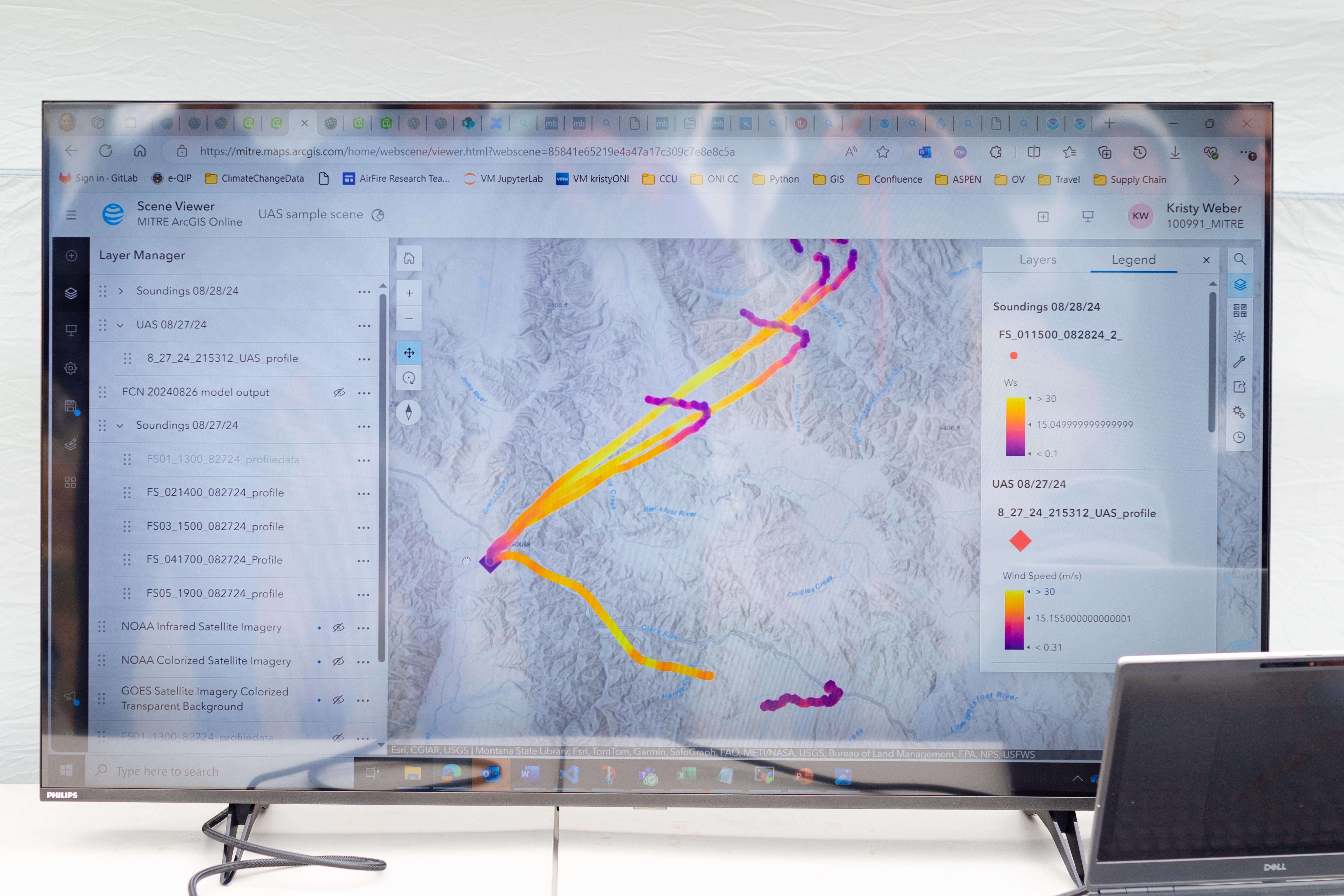
Once those data sets were created, they needed to be transformed into a usable format. Meteorologists are used to the numbers, but incident commanders on an active fire need to see the data in a form that allows them to quickly understand which conditions are changing, and how. That’s where data visualization partners come in. For the Missoula campaign, teams from MITRE, NVIDIA, and Esri joined NASA in the field.
An early data visualization from the Esri team shows the flight paths of weather balloons launched on the first day of the FireSense UAS technology demonstration in Missoula. The paths are color-coded by wind speed, from purple (low wind) to bright yellow (high wind).
NASA/Milan Loiacono
Measurements from both the balloon and the drone platforms were immediately sent to the on-site data teams. The MITRE team, together with NVIDIA, tested high-resolution artificial intelligence meteorological models, while the Esri team created comprehensive visualizations of flight paths, temperatures, and wind speed and direction. These visual representations of the data make conclusions more immediately apparent to non-meteorologists.
What’s Next?
Development of drone capabilities for fire monitoring didn’t begin in Missoula, and it won’t end there.
“This campaign leveraged almost a decade of research, development, engineering, and testing,” said McSwain. “We have built up a UAS flight capability that can now be used across NASA.”
This campaign leveraged almost a decade of research, development, engineering, and testing. We have built up a UAS flight capability that can now be used across NASA.
Robert Mcswain
FireSense Uncrewed Aerial System (UAS) Lead
The NASA Alta X and its sensor payload will head to Alabama and Florida in spring 2025, incorporating improvements identified in Montana. There, the team will perform another technology demonstration with wildland fire managers from a different region.
The FireSense project is led by NASA Headquarters in Washington and sits within the Wildland Fires program, with the project office based at NASA Ames. The goal of FireSense is to transition Earth science and technological capabilities to operational wildland fire management agencies, to address challenges in U.S. wildland fire management before, during, and after a fire.
About the Author
Milan Loiacono
Science Communication Specialist
Milan Loiacono is a science communication specialist for the Earth Science Division at NASA Ames Research Center.
For more than a decade, Tristan McKnight has been a driving force behind some of NASA’s most iconic events, orchestrating the behind-the-scenes magic that brings each historic moment to life while sharing the agency’s advancements with the public.
As a multimedia producer on the audiovisual team at Johnson Space Center in Houston, McKnight produces and directs live broadcasts and manages event planning, coordination, and execution. From overseeing resources, mitigating risks, and communicating with stakeholders, he ensures every detail aligns seamlessly.
Official portrait of Tristan McKnight.
NASA/Josh Valcarcel
McKnight has played an integral role in the audiovisual team’s coverage of major events including the Artemis II crew announcement, where NASA revealed the astronauts who will venture around the Moon and back, to Johnson’s 2023 Open House, which celebrated the agency’s 65th anniversary and the 25th anniversary of the International Space Station’s operations. These achievements highlight key milestones in human space exploration.
The team’s dedication and passion are a testament to their commitment to sharing NASA’s legacy with the world.
“Not only have these events been impactful to Johnson, but they have also resonated across the entire agency,” McKnight said. “That is what I’m most proud of!”
Tristan McKnight at the 45th Annual Original Martin Luther King Jr. Day Parade in downtown Houston.
NASA/James Blair
One of McKnight’s most memorable events was the 2023 “Back in the Saddle,” an annual tradition designed to refocus Johnson’s workforce at the start of a new year and renew the center’s commitment to safety and mission excellence. McKnight recalled how the speaker transformed Johnson’s Teague Auditorium into a venue filled with drum kits, inspiring messages, and lighting displays. Each audience member, drumsticks in hand, participated in a lesson on teamwork and synchronization to create a metaphor for working in harmony toward a shared goal.
Like many high-achieving professionals. McKnight has faced moments of self-doubt. Then he realized that he is exactly where he is supposed to be. “As I settled into my role, I recognized that my contributions matter and simply being true to who I am adds value to the Johnson community,” he said.
Tristan McKnight (right) receives a Group Special Act Award from Johnson Space Center Director Vanessa Wyche for his contributions to the Dorothy Vaughn in Honor of the Women of Apollo naming ceremony.
NASA
Each day brings its own set of challenges, ranging from minor issues like communication gaps and scheduling conflicts to major obstacles like technology failures. One of McKnight’s most valuable lessons is recognizing that there is no one-size-fits-all solution, and each situation requires a thoughtful analysis.
McKnight understands the importance of the “check-and double-check,” a philosophy he considers crucial when working with technology. “Taking the extra time to do your due diligence, or even having someone else take a look, can make all the difference,” he said.
“The challenges I’ve faced helped me grow as a problem solver and taught me valuable lessons on resilience and adaptability in the workplace,” he said. McKnight approaches obstacles with a level head, focusing on effective solutions rather than dwelling on the problem.
Tristan McKnight (left) with his daughter Lydia McKnight and Johnson’s External Relations Director Arturo Sanchez at the 2024 Bring Your Youth To Work Day.
NASA/Helen Arase Vargas
As humanity looks to the stars, McKnight is energized about the future of exploration, particularly advancements in spacesuit and rocket technology that will enable us to travel farther, faster, and safer than ever before. His work, though grounded on Earth, helps create the inspiration that fuels these bold endeavors.
“My hope for the next generation is that they dive deeper into their curiosity—exploring not only the world around them but also the Moon, planets, and beyond,” he said. “I also hope they carry forward the spirit of resilience and a commitment to making the world a better place for all.”
NASA Tests Drones to Provide Micrometeorology, Aid in Fire Response
Pilot in command Brayden Chamberlain performs pre-flight checks on the NASA Alta X quadcopter during the FireSense uncrewed aerial system (UAS) technology demonstration in Missoula.
Credits: NASA ARC/Milan Loiacono
In Aug. 2024, a team of NASA researchers and partners gathered in Missoula, to test new drone-based technology for localized forecasting, or micrometeorology. Researchers attached wind sensors to a drone, NASA’s Alta X quadcopter, aiming to provide precise and sustainable meteorological data to help predict fire behavior.
Wildfires are increasing in number and severity around the world, including the United States, and wind is a major factor. It leads to unexpected and unpredictable fire growth, public threats, and fire fatalities, making micrometeorology a very effective tool to combat fire.
This composite image shows the NASA Alta X quadcopter taking off during one of eight flights it performed for the 2024 FireSense UAS technology demonstration in Missoula. Mounted on top of the drone is a unique infrastructure designed at NASA’s Langley Research Center in Hampton,Virginia, to carry sensors that measure wind speed and direction into the sky. On the ground, UAS pilot in command Brayden Chamberlain performs final pre-flight checks.
NASA/Milan Loiacono
The campaign was run by NASA’s FireSense project, focused on addressing challenges in wildland fire management by putting NASA science and technology in the hands of operational agencies.
“Ensuring that the new technology will be easily adoptable by operational agencies such as the U.S. Forest Service and the National Weather Service was another primary goal of the campaign,” said Jacquelyn Shuman, FireSense project scientist at NASA’s Ames Research Center in California’s Silicon Valley.
The FireSense team chose the Alta X drone because the U.S. Forest Service already has a fleet of the quadcopters and trained drone pilots, which could make integrating the needed sensors – and the accompanying infrastructure – much easier and more cost-effective for the agency.
The UAS pilot in command, Brayden Chamberlain, flashes a “good to go” signal to the command tent, indicating that the NASA Alta X quadcopter is prepped for takeoff. Behind Chamberlain, the custom structure attached to the quadcopter holds a radiosonde (small white box) and an anemometer (hidden from view), which will collect data on wind speed and direction, humidity, temperature, and pressure.
NASA/Milan Loiacono
The choice of the two sensors for the drone’s payload was also driven by their adoptability.
The first, called a radiosonde, measures wind direction and speed, humidity, temperature, and pressure, and is used daily by the National Weather Service. The other sensor, an anemometer, measures wind speed and direction, and is used at weather stations and airports around the world.
The two sensors mounted on the NASA Alta X quadcopter are a radiosonde (left) and an anemometer (right), which measure wind speed and direction. The FireSense teams hopes that by giving them wings, researchers can enable micrometeorology to better predict fire and smoke behavior.
NASA/Milan Loiacono
“Anemometers are everywhere, but are usually stationary,” said Robert McSwain, the FireSense uncrewed aerial system (UAS) lead, based at NASA’s Langley Research Center in Hampton, Virginia. “We are taking a sensor type that is already used all over the world, and giving it wings.”
Anemometers are everywhere, but are usually stationary. We are taking a sensor type that is already used all over the world, and giving it wings.
Robert Mcswain
FireSense Uncrewed Aerial System (UAS) Lead
Both sensors create datasets that are already familiar to meteorologists worldwide, which opens up the potential applications of the platform.
Current Forecasting Methods: Weather Balloons
Traditionally, global weather forecasting data is gathered by attaching a radiosonde to a weather balloon and releasing it into the air. This system works well for regional weather forecasts. But the rapidly changing environment of wildland fire requires more recurrent, pinpointed forecasts to accurately predict fire behavior. It’s the perfect niche for a drone.
Left: Steven Stratham (right) attaches a radiosonde to the string of a weather balloon as teammates Travis Christopher (left) and Danny Johnson (center) prepare the balloon for launch. This team of three from Salish Kootenai College is one of many college teams across the nation trained to prepare and launch weather balloons. Right: One of these weather balloons lifts into the sky, with the radiosonde visible at the end of the string.
NASA/Milan Loiacono
“These drones are not meant to replace the weather balloons,” said Jennifer Fowler, FireSense’s project manager at Langley. “The goal is to create a drop-in solution to get more frequent, localized data for wildfires – not to replace all weather forecasting.”
The goal is to create a drop-in solution to get more frequent, localized data for wildfires – not to replace all weather forecasting.
Jennifer Fowler
FireSense Project Manager
Drones Provide Control, Repeat Testing, Sustainability
Drones can be piloted to keep making measurements over a precise location – an on-site forecaster could fly one every couple of hours as conditions change – and gather timely data to help determine how weather will impact the direction and speed of a fire.
Fire crews on the ground may need this information to make quick decisions about where to deploy firefighters and resources, draw fire lines, and protect nearby communities.
A reusable platform, like a drone, also reduces the financial and environmental impact of forecasting flights.
“A weather balloon is going to be a one-off, and the attached sensor won’t be recovered,” Fowler said. “The instrumented drone, on the other hand, can be flown repeatedly.”
The NASA Alta X quadcopter sits in a field in Missoula, outfitted with a special structure to carry a radiosonde (sensor on the left) and an anemometer (sensor on the right) into the air. This structure was engineered at NASA’s Langley Research Center to ensure the sensors are far enough from the rotors to avoid interfering with the data collected, but without compromising the stability of the drone.
NASA/Milan Loiacono
The Missoula Campaign
Before such technology can be sent out to a fire, it needs to be tested. That’s what the FireSense team did this summer.
Smoke from the nearby Miller Peak Fire drifts by the air control tower at Missoula Airport on August 29, 2024. Miller Peak was one of several fires burning in and around Missoula that month, creating a smokey environment which, combined with the mountainous terrain, made the area an ideal location to test FireSense’s new micrometeorology technology.
NASA/Milan Loiacono
McSwain described the conditions in Missoula as an “alignment of stars” for the research: the complex mountain terrain produces erratic, historically unpredictable winds, and the sparsity of monitoring instruments on the ground makes weather forecasting very difficult. During the three-day campaign, several fires burned nearby, which allowed researchers to test how the drones performed in smokey conditions.
A drone team out of NASA Langley conducted eight data-collection flights in Missoula. Before each drone flight, student teams from the University of Idaho in Moscow, Idaho, and Salish Kootenai College in Pablo, Montana, launched a weather balloon carrying the same type of radiometer.
Left: Weather balloon teams from University of Idaho and Salish Kootenai College prepare a weather balloon for launch on the second day of the FireSense campaign in Missoula. Right: NASA Langley drone crew members Todd Ferrante (left) and Brayden Chamberlain (right) calibrate the internal sensors of the NASA Alta X quadcopter before its first test flight on Aug. 27, 2024.
Once those data sets were created, they needed to be transformed into a usable format. Meteorologists are used to the numbers, but incident commanders on an active fire need to see the data in a form that allows them to quickly understand which conditions are changing, and how. That’s where data visualization partners come in. For the Missoula campaign, teams from MITRE, NVIDIA, and Esri joined NASA in the field.
An early data visualization from the Esri team shows the flight paths of weather balloons launched on the first day of the FireSense UAS technology demonstration in Missoula. The paths are color-coded by wind speed, from purple (low wind) to bright yellow (high wind).
NASA/Milan Loiacono
Measurements from both the balloon and the drone platforms were immediately sent to the on-site data teams. The MITRE team, together with NVIDIA, tested high-resolution artificial intelligence meteorological models, while the Esri team created comprehensive visualizations of flight paths, temperatures, and wind speed and direction. These visual representations of the data make conclusions more immediately apparent to non-meteorologists.
What’s Next?
Development of drone capabilities for fire monitoring didn’t begin in Missoula, and it won’t end there.
“This campaign leveraged almost a decade of research, development, engineering, and testing,” said McSwain. “We have built up a UAS flight capability that can now be used across NASA.”
This campaign leveraged almost a decade of research, development, engineering, and testing. We have built up a UAS flight capability that can now be used across NASA.
Robert Mcswain
FireSense Uncrewed Aerial System (UAS) Lead
The NASA Alta X and its sensor payload will head to Alabama and Florida in spring 2025, incorporating improvements identified in Montana. There, the team will perform another technology demonstration with wildland fire managers from a different region.
The FireSense project is led by NASA Headquarters in Washington and sits within the Wildland Fires program, with the project office based at NASA Ames. The goal of FireSense is to transition Earth science and technological capabilities to operational wildland fire management agencies, to address challenges in U.S. wildland fire management before, during, and after a fire.
About the Author
Milan Loiacono
Science Communication Specialist
Milan Loiacono is a science communication specialist for the Earth Science Division at NASA Ames Research Center.
Preparations for Next Moonwalk Simulations Underway (and Underwater)
We’ve been talking about this for 2,000 years. Aristotle mentions it. And in our own time, scientists are designing experiments to figure out exactly what’s going on. But there’s no consensus yet.
Here’s what we do know.
The atmosphere isn’t magnifying the Moon. If anything, atmospheric refraction squashes it a little bit. And the Moon’s not closer to us at the horizon. It’s about 1.5 percent farther away. Also, it isn’t just the Moon. Constellations look huge on the horizon, too.
One popular idea is that this is a variation on the Ponzo illusion. Everything in our experience seems to shrink as it recedes toward the horizon — I mean clouds and planes and cars and ships. But the Moon doesn’t do that. So our minds make up a story to reconcile this inconsistency. Somehow the Moon gets bigger when it’s at the horizon. That’s one popular hypothesis, but there are others. And we’re still waiting for the experiment that will convince everyone that we understand this.
So why does the Moon look larger on the horizon? We don’t really know, but scientists are still trying to figure it out.
NASA asked artists to imagine the future of deep space exploration in artwork meant to inspire the Artemis Generation. The NASA Moon to Mars Architecture art challenge sought creative images that represent the agency’s bold vision for crewed exploration of the lunar surface and the Red Planet. The agency has selected the recipients of the art challenge competition.
This collage features all the winners of the NASA Moon to Mars Architecture Art Challenge.
Jimmy Catanzaro, Jean-Luc Sabourin, Irene Magi, Pavlo Kandyba, Antonella Di Cristofaro, Francesco Simone, Mia Nickell, Lux Bodell, Olivia De Grande, Sophie Duan
The challenge, hosted by contractor yet2 through NASA’s Prizes, Challenges, and Crowdsourcing program, was open to artists from around the globe. Guidelines asked artists to consider NASA’s Moon to Mars Architecture development effort, which uses engineering processes to distil NASA’s Moon to Mars Objectives into the systems needed to accomplish them. NASA received 313 submissions from 22 U.S. states and 47 countries.
The architecture includes four segments of increasing complexity. For this competition, NASA sought artistic representations of the two furthest on the timeline: the Sustained Lunar Evolution segment and the Humans to Mars segment.
The Sustained Lunar Evolution segment is an open canvas for exploration of the Moon, embracing new ideas, systems, and partners to grow to a long-term presence on the lunar surface. Sustained lunar evolution means more astronauts on the Moon for longer periods of time, increased opportunities for science, and even the large-scale production of goods and services derived from lunar resources. It also means increased cooperation and collaboration with international partners and the aerospace industry to build a robust lunar economy.
The Humans to Mars segment will see the first human missions to Mars, building on the lessons we learn from exploring the Moon. These early missions will focus on Martian exploration and establishing the foundation for a sustained Mars presence. NASA architects are examining a wide variety of options for transportation, habitation, power generation, utilization of Martian resources, scientific investigations, and more.
Final judging for the competition took place at NASA’s annual Architecture Concept Review meeting. That review brought together agency leadership from NASA mission directorates, centers, and technical authorities to review the 2024 updates to the Moon to Mars Architecture. NASA selected the winning images below during that review:
You would not expect to see NASA at a car show—but that’s exactly where Johnson Space Center employees were from Jan. 29 to Feb. 2, 2025, driving the future of space exploration forward.
At the Houston AutoBoative Show, a fusion of the auto and boat show, NASA rolled out its Artemis exhibit at NRG Center for the first time, introducing vehicle enthusiasts to the technologies NASA and commercial partners will use to explore more of the lunar surface than ever before.
Johnson Space Center employees present the Artemis exhibit at the 2025 Houston AutoBoative Show at NRG Center.
NASA/Robert Markowitz
The Artemis exhibit stood alongside some of the world’s most advanced cars and boats, offering visitors an up-close look at lunar terrain vehicle mockups from Astrolab, Intuitive Machines, and Lunar Outpost. Later this year, NASA will select the rover that will fly to the Moon as humanity prepares for the next giant leap.
In addition to the rovers, the exhibit featured a mockup of JAXA’s (Japan Aerospace Exploration Agency) pressurized rover, designed as a mobile habitat for astronauts, and Axiom Space’s lunar spacesuit, developed for Artemis III astronauts.
These capabilities will allow astronauts to explore, conduct science research, and live and work on the lunar surface.
Strategic Communications Manager for NASA’s Extravehicular Activity and Human Surface Mobility Program Tim Hall (right) shows Johnson Director Vanessa Wyche and Johnson External Relations Office Director Arturo Sanchez the Artemis booth.
NASA/Robert Markowitz
Johnson Director Vanessa Wyche visited the Artemis exhibit to highlight the importance of these technologies in advancing lunar exploration. Every lesson learned on the Moon will help scientists and engineers develop the strategies, technologies, and experience needed to send astronauts to Mars.
“By bringing the excitement of lunar exploration to the AutoBoative Show, NASA aims to inspire the next generation of explorers to dream bigger, push farther, and help shape humanity’s future in space,” Wyche said.
NASA’s Artemis campaign is setting the stage for long-term human exploration, working with commercial and international partners to establish a sustained presence on the Moon before progressing to Mars.
To make this vision a reality, NASA is developing rockets, spacecraft, landing systems, spacesuits, rovers, habitats, and more.
Vanessa Wyche views Axiom Space’s lunar spacesuit at the exhibit.
NASA/Robert Markowitz
Some of the key elements on display at the show included:
The Orion spacecraft – Designed to take astronauts farther into deep space. Orion will launch atop NASA’s Space Launch System (SLS) rocket, carrying the crew to the Moon on Artemis missions and safely returning them to Earth.
Lunar terrain vehicles – Developed to transport astronauts across the rugged lunar surface or be remotely operated. NASA recently put these rover mockups to the test at Johnson, where astronauts and engineers, wearing spacesuits, ran through critical maneuvers, tasks, and emergency drills—including a simulated crew rescue.
Next-gen spacesuits and tools – Through Johnson’s Extravehicular Activity and Human Surface Mobility Program, astronauts’ gear and equipment are designed to ensure safety and efficiency while working on the Moon’s surface.
NASA’s Orion Program Strategic Communications Manager Radislav Sinyak (left) and Orion Communications Strategist Erika Peters guide Vanessa Wyche through navigating the Orion spacecraft to dock with the lunar space station Gateway.
NASA/Robert Markowitz
Guests had the chance to step into the role of an astronaut with interactive experiences like:
Driving a lunar rover simulator – Testing their skills at the wheel of a virtual Moon rover.
Practicing a simulated Orion docking – Experiencing the precision needed to connect to Gateway in lunar orbit.
Exploring Artemis II and III mission roadmaps – Learning about NASA’s upcoming missions and goals.
Attendees also discovered how American companies are delivering science and technology to the Moon through NASA’s Commercial Lunar Payload Services initiative.
Johnson employees from the Orion program showcase the Orion simulator at the exhibit. From left: Orion Crew and Service Module Office Crew Systems Manager Paul Boehm, Lead Admin Dee Maher, and Orion Crew and Service Module Integration Lead Mark Cavanaugh. From right: Vanessa Wyche, Erika Peters, and Radislav Sinyak.
NASA/Robert Markowitz
“Everyone can relate to exploration, so it was great to teach people the importance lunar rovers will have on astronauts’ abilities to explore more of the lunar surface while conducting science,” said Victoria Ugalde, communications strategist for the Extravehicular Activity and Human Surface Mobility Program, who coordinated the lunar rovers’ appearance at the show.
Check out the rovers contracted to develop lunar terrain vehicle capabilities below.
This study showed that the International Space Station’s ECOSTRESS instrument estimates of evapotranspiration (transfer of water to the atmosphere from Earth’s surface and plants) are comparable to ground-based reference values. This finding suggests space measurements could provide guidance for improved water management on large scales.
Worsening droughts due to climate change require better water management. Evapotranspiration is a critical part of the hydrologic cycle, but data are lacking on local water conditions and demands. California’s Eastern Municipal Water District uses the ground-based California Irrigation Management Information System to track evapotranspiration, but it has limited spatial coverage and consistency. Space-based estimates could be better and more consistent.
The ECOSTRESS instrument, the white box in the center, is visible on the outside of the station.
NASA
Four-legged robotic retrievers
Space station crew members successfully located and retrieved an object in a simulated Mars environment using a remotely controlled four-legged robot, Bert. Legged robots could provide the ability to explore and survey different extraterrestrial surfaces on future missions.
On uneven lunar and planetary surfaces, robots with legs could explore areas inaccessible to wheeled rovers. Surface Avatar, an investigation from ESA (European Space Agency), evaluated remote control of multiple robots in space, providing information on how human operators respond to physical feedback (such as feeling a bump when a robot arm makes contact) and identifying challenges for orbit-to-ground remote operation of robots. The German Aerospace Center is developing Bert.
ESA astronaut Samantha Cristoforetti practices maneuvers for the Surface Avatar investigation.
NASA
Technology supports atmospheric studies
Researchers found that the Compact Thermal Imager (CTI) on the space station produced scientifically useful imagery of atmospheric phenomena, including gravity waves, clouds, and volcanic plumes. This technology could change current practices and instrument design for remote sensing of Earth from space.
The CTI is mounted on hardware for Robotic Refueling Mission 3, which tested technology for the robotic transfer and storage of cryogenic fluids in microgravity. The station’s orbit provides near-global coverage and CTI has reduced size, energy use, and cost. Its images can measure fires, ice sheets, glaciers, and snow surface temperatures on the ground and the transfer of water from soil and plants into the atmosphere.
NASA astronaut Anne McClain and CSA astronaut David Saint-Jacques installing the RRM3 hardware.
The order came in response to a lawsuit filed by 19 attorneys general accusing the president of failing to faithfully execute the nation’s laws when he let DOGE comb through federal computer systems.
A coalition of attorneys general are seeking to bypass President Joe Biden's last-minute preemptive pardon of Dr. Anthony Fauci to investigate him on a state level for his role in the COVID-19 pandemic response.
Newly-sworn in U.S. Attorney General Pam Bondi has gotten straight to work on her first day by directing the Department of Justice (DOJ) to "pause all federal funding for sanctuary cities," according to a Wednesday report.
NASA’s Ames Research Center in Silicon Valley invites media to learn more about Distributed Spacecraft Autonomy (DSA), a technology that allows individual spacecraft to make independent decisions while collaborating with each other to achieve common goals – without human input. The DSA team achieved multiple firsts during tests of such swarm technology as part of the agency’s project.
DSA develops software tools critical for future autonomous, distributed, and intelligent spacecraft that will need to interact with each other to achieve complex mission objectives. Testing onboard the agency’s Starling mission resulted in accomplishments including the first fully distributed autonomous operation of multiple spacecraft, the first use of space-to-space communications to autonomously share status information between multiple spacecraft, and more.
DSA’s accomplishments mark a significant milestone in advancing autonomous systems that will make new types of science and exploration possible.
Caleb Adams, DSA project manager, is available for interview on Wednesday, Feb. 5 and Thursday, Feb. 6. To request an interview, media can contact the Ames Office of Communications by email at arc-dl-newsroom@nasa.gov or by phone at 650-604-4789.
Learn more about NASA Ames’ world-class research and development in aeronautics, science, and exploration technology at:
To receive local NASA Ames news, email local-reporters-request@lists.arc.nasa.gov with “subscribe” in the subject line. To unsubscribe, email the same address with “unsubscribe” in the subject line.
For astronauts aboard the International Space Station, staying connected to loved ones and maintaining a sense of normalcy is critical. That is where Tandra Gill Spain, a computer resources senior project manager in NASA’s Avionics and Software Office, comes in. Spain leads the integration of applications on Apple devices and the hardware integration on the Joint Station Local Area Network, which connects the systems from various space agencies on the International Space Station. She also provides technical lead support to the Systems Engineering and Space Operations Computing teams and certifies hardware for use on the orbiting laboratory.
Spain shares about her career with NASA and more. Read on to learn about her story, her favorite project, and the advice she has for the next generation of explorers.
Tandra Spain’s official NASA portrait.
NASA
Where are you from?
I am from Milwaukee, Wisconsin.
Tell us about your role at NASA.
I am the Apple subsystem manager where I lead the integration of applications on Apple devices as well as the hardware integration on the Joint Station Local Area Network. We use a variety of different software but I work specifically with our Apple products. I also provide technical lead support to the Systems Engineering and Space Operations Computing teams. In addition, I select and oversee the certification of hardware for use on the International Space Station, and I research commonly used technology and assess applicability to space operations.
How would you describe your job to family or friends who may not be familiar with NASA?
I normalize living and working in space by providing the comforts and conveniences of living on Earth.
Tandra spain
Computer Resources Senior Project Manager
I get the opportunity to provide the iPads and associated applications that give astronauts the resources to access the internet. Having access to the internet affords them the opportunity to stay as connected as they desire with what is going on back home on Earth (e.g., stream media content, stay in touch with family and friends, and even pay bills). I also provide hardware such as Bluetooth speakers, AirPods, video projectors, and screens.
How long have you been working for NASA?
I have been with the agency for 30 years, including 22 years as a contractor.
What advice would you give to young individuals aspiring to work in the space industry or at NASA?
I have found that there is a place for just about everyone at NASA, therefore, follow your passion. Although many of us are, you don’t have to be a scientist or engineer to work at NASA. Yearn to learn. Pause and listen to those around you. You don’t know what you don’t know, and you will be amazed what gems you’ll learn in the most unexpected situations.
Additionally, be flexible and find gratitude in every experience. Many of the roles that I’ve had over the years didn’t come from a well-crafted, laid-out plan that I executed, but came from taking advantage of the opportunities that presented themselves and doing them to the best of my ability.
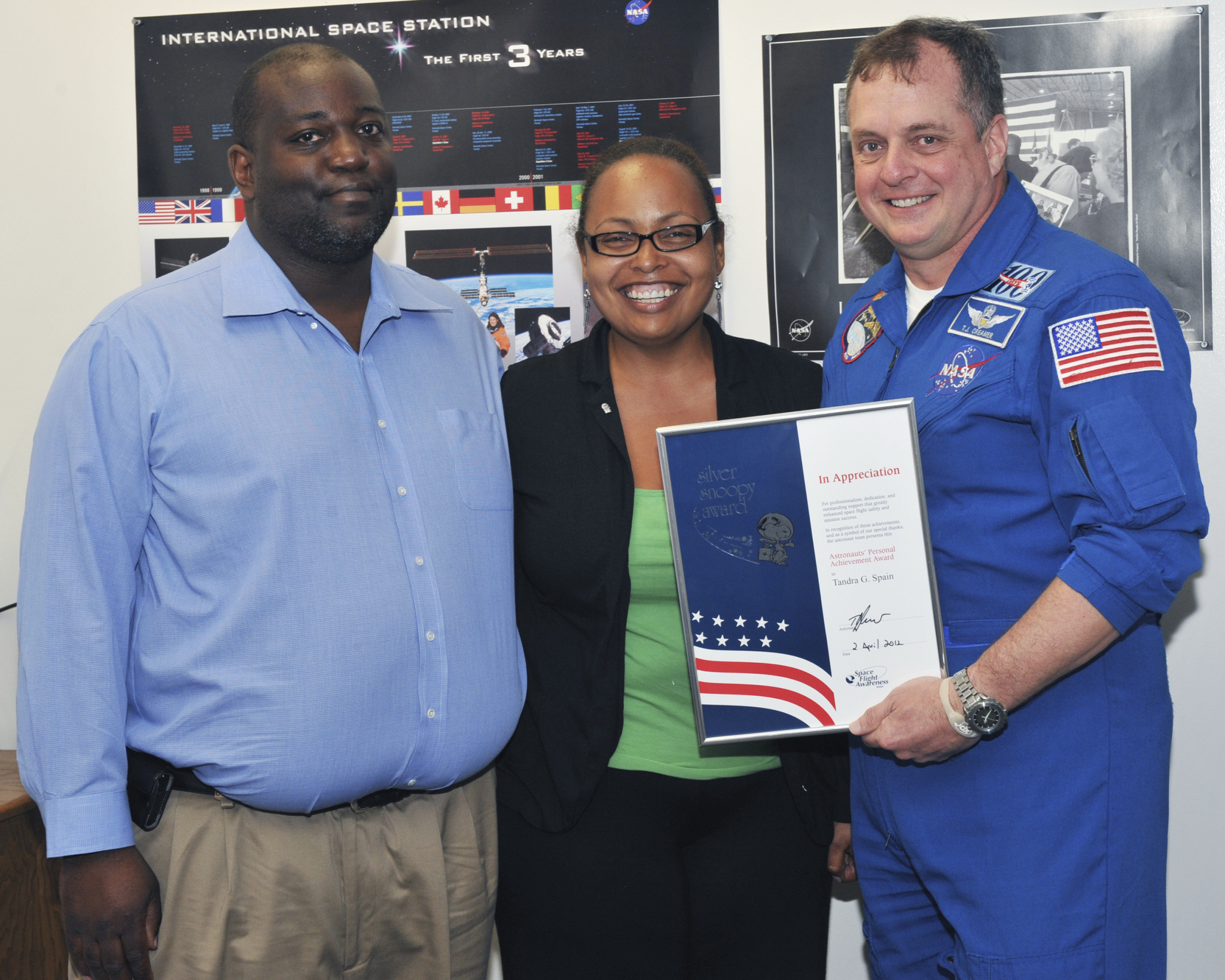
Tandra Spain and her husband, Ivan, with NASA astronaut and Flight Director TJ Creamer when she was awarded the Silver Snoopy Award.
What was your path to NASA?
I moved to Houston to work at NASA’s Johnson Space Center immediately upon graduating from college.
Is there someone in the space, aerospace, or science industry that has motivated or inspired you to work for the space program? Or someone you discovered while working for NASA who inspires you?
I spent over half of my career in the Astronaut Office, and I’ve been influenced in different ways by different people, so it wouldn’t be fair to pick just one!
What is your favorite NASA memory?
I’ve worked on so many meaningful projects, but there are two recent projects that stand out.
Humans were not created to be alone, and connection is extremely important. I was able to provide a telehealth platform for astronauts to autonomously video conference with friends and family whenever an internet connection is available. Prior to having this capability, crew were limited to one scheduled video conference a week. It makes me emotional to think that we have moms and dads orbiting the Earth on the space station and they can see their babies before they go to bed, when they wake up in the morning, or even in the middle of the night if needed.
In addition, since iPads are used for work as well as personal activities on station, it is important for my team to be able to efficiently keep the applications and security patches up to date. We completed the software integration and are in the process of wrapping up the certification of the Mac Mini to provide this capability. This will allow us to keep up with all software updates that Apple releases on a regular basis and minimize the amount of crew and flight controller team time associated with the task by approximately 85%.
Tandra Spain, her mother, Marva Herndon, and her daughter, Sasha, at her daughter’s high school graduation in 2024.
What do you love sharing about station? What’s important to get across to general audiences to help them understand the benefits to life on Earth?
When I speak to the public about the space station, I like to compare our everyday lives on Earth to life on the station and highlight the use of technology to maintain the connection to those on Earth. For example, most people have a phone. Besides making a phone call, what do you use your phone for? It is amazing to know that the same capabilities exist on station, such as using apps, participating in parent teacher conferences, and more.
If you could have dinner with any astronaut, past or present, who would it be?
I would have dinner with NASA astronaut Ron McNair. He graduated from the same university as I did, and I’ve heard great stories about him.
Do you have a favorite space-related memory or moment that stands out to you?
As I mentioned previously, human connection is extremely important. As an engineer in the Astronaut Office, I worked on a project that provided more frequent email updates when Ku-Band communication was available. Previously, email was synced two to three times a day, and less on the weekend. When the capability went active, I sent the first email exchange.
What are some of the key projects you’ve worked on during your time at NASA? What have been your favorite?
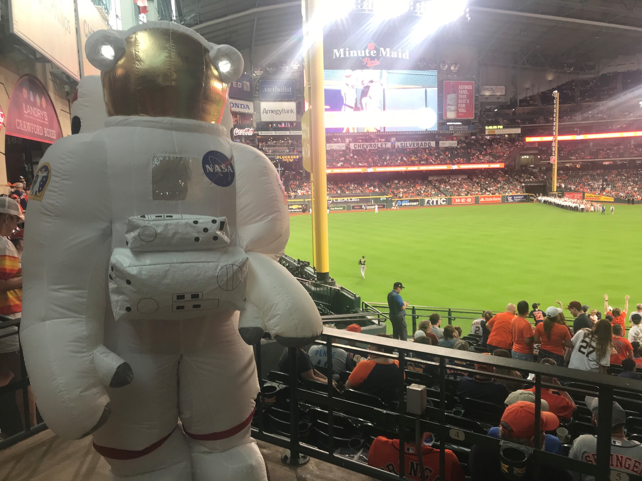
There have been so many projects over the past 30 years that I don’t think I could select just one. There is something however, that I’ve done on many occasions that has brought me pure joy, which is attending outreach events as Johnson’s “Cosmo” mascot, especially Houston Astros games.
Tandra Spain representing NASA as “Cosmo” the astronaut mascot at a Houston Astros baseball game.
What are your hobbies/things you enjoy outside of work?
I enjoy crafting, traveling, mentoring students in Pearland Independent School District, spending time with family, and my Rooted Together community.
Day launch or night launch?
Night launch!
Favorite space movie?
Star Wars (the original version)
NASA “worm” or “meatball” logo?
Meatball
Every day, we’re conducting exciting research aboard our orbiting laboratory that will help us explore further into space and bring benefits back to people on Earth. You can keep up with the latest news, videos, and pictures about space station science on the Station Research & Technology news page. It’s a curated hub of space station research digital media from Johnson and other centers and space agencies.
Sign up for our weekly email newsletter to get the updates delivered directly to you.
Follow updates on social media at @ISS_Research on Twitter, and on the space station accounts on Facebook and Instagram.
Publicly released agreements show the vast wealth of President Trump’s cabinet picks and the uncharacteristically large list of potential conflicts of interest with which they enter office.