A former high school classmate of Los Angeles Mayor Karen Bass has written to the L.A. Times to defend the mayor's conduct during the Palisades Fire -- which broke out when Bass was abroad at Ghana's presidential inauguration.
Los Angeles residents are furious at an announcement by the Army Corps of Engineers that there will be no testing of local soil for toxins after the first six inches of topsoil are taken away during debris removal that began this week.
The Los Angeles Fire Department (LAFD) could have pre-deployed ten engines to the Pacific Palisades ahead of the deadly Palisades Fire on January 7, but chose not to, according to former fire chiefs quoted by the Los Angeles Times.
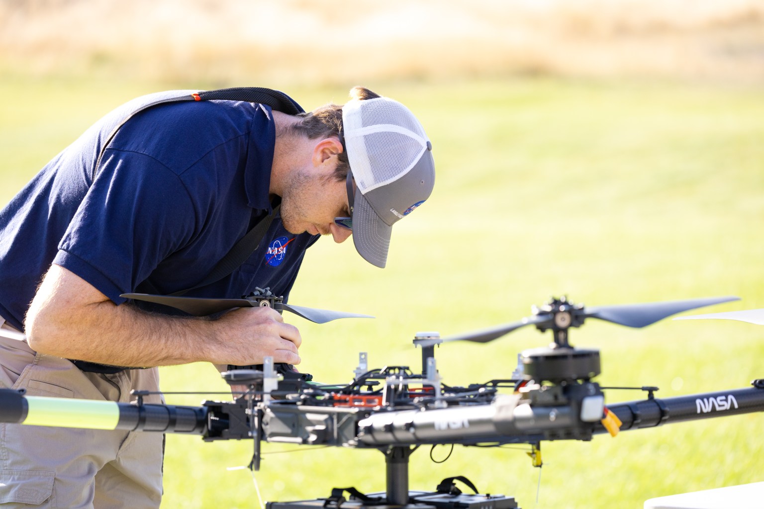
NASA Tests Drones to Provide Micrometeorology, Aid in Fire Response
Pilot in command Brayden Chamberlain performs pre-flight checks on the NASA Alta X quadcopter during the FireSense uncrewed aerial system (UAS) technology demonstration in Missoula.
Credits: NASA ARC/Milan Loiacono
In Aug. 2024, a team of NASA researchers and partners gathered in Missoula, to test new drone-based technology for localized forecasting, or micrometeorology. Researchers attached wind sensors to a drone, NASA’s Alta X quadcopter, aiming to provide precise and sustainable meteorological data to help predict fire behavior.
Wildfires are increasing in number and severity around the world, including the United States, and wind is a major factor. It leads to unexpected and unpredictable fire growth, public threats, and fire fatalities, making micrometeorology a very effective tool to combat fire.
This composite image shows the NASA Alta X quadcopter taking off during one of eight flights it performed for the 2024 FireSense UAS technology demonstration in Missoula. Mounted on top of the drone is a unique infrastructure designed at NASA’s Langley Research Center in Hampton,Virginia, to carry sensors that measure wind speed and direction into the sky. On the ground, UAS pilot in command Brayden Chamberlain performs final pre-flight checks.
NASA/Milan Loiacono
The campaign was run by NASA’s FireSense project, focused on addressing challenges in wildland fire management by putting NASA science and technology in the hands of operational agencies.
“Ensuring that the new technology will be easily adoptable by operational agencies such as the U.S. Forest Service and the National Weather Service was another primary goal of the campaign,” said Jacquelyn Shuman, FireSense project scientist at NASA’s Ames Research Center in California’s Silicon Valley.
The FireSense team chose the Alta X drone because the U.S. Forest Service already has a fleet of the quadcopters and trained drone pilots, which could make integrating the needed sensors – and the accompanying infrastructure – much easier and more cost-effective for the agency.
The UAS pilot in command, Brayden Chamberlain, flashes a “good to go” signal to the command tent, indicating that the NASA Alta X quadcopter is prepped for takeoff. Behind Chamberlain, the custom structure attached to the quadcopter holds a radiosonde (small white box) and an anemometer (hidden from view), which will collect data on wind speed and direction, humidity, temperature, and pressure.
NASA/Milan Loiacono
The choice of the two sensors for the drone’s payload was also driven by their adoptability.
The first, called a radiosonde, measures wind direction and speed, humidity, temperature, and pressure, and is used daily by the National Weather Service. The other sensor, an anemometer, measures wind speed and direction, and is used at weather stations and airports around the world.
The two sensors mounted on the NASA Alta X quadcopter are a radiosonde (left) and an anemometer (right), which measure wind speed and direction. The FireSense teams hopes that by giving them wings, researchers can enable micrometeorology to better predict fire and smoke behavior.
NASA/Milan Loiacono
“Anemometers are everywhere, but are usually stationary,” said Robert McSwain, the FireSense uncrewed aerial system (UAS) lead, based at NASA’s Langley Research Center in Hampton, Virginia. “We are taking a sensor type that is already used all over the world, and giving it wings.”
Anemometers are everywhere, but are usually stationary. We are taking a sensor type that is already used all over the world, and giving it wings.
Robert Mcswain
FireSense Uncrewed Aerial System (UAS) Lead
Both sensors create datasets that are already familiar to meteorologists worldwide, which opens up the potential applications of the platform.
Current Forecasting Methods: Weather Balloons
Traditionally, global weather forecasting data is gathered by attaching a radiosonde to a weather balloon and releasing it into the air. This system works well for regional weather forecasts. But the rapidly changing environment of wildland fire requires more recurrent, pinpointed forecasts to accurately predict fire behavior. It’s the perfect niche for a drone.
Left: Steven Stratham (right) attaches a radiosonde to the string of a weather balloon as teammates Travis Christopher (left) and Danny Johnson (center) prepare the balloon for launch. This team of three from Salish Kootenai College is one of many college teams across the nation trained to prepare and launch weather balloons. Right: One of these weather balloons lifts into the sky, with the radiosonde visible at the end of the string.
NASA/Milan Loiacono
“These drones are not meant to replace the weather balloons,” said Jennifer Fowler, FireSense’s project manager at Langley. “The goal is to create a drop-in solution to get more frequent, localized data for wildfires – not to replace all weather forecasting.”
The goal is to create a drop-in solution to get more frequent, localized data for wildfires – not to replace all weather forecasting.
Jennifer Fowler
FireSense Project Manager
Drones Provide Control, Repeat Testing, Sustainability
Drones can be piloted to keep making measurements over a precise location – an on-site forecaster could fly one every couple of hours as conditions change – and gather timely data to help determine how weather will impact the direction and speed of a fire.
Fire crews on the ground may need this information to make quick decisions about where to deploy firefighters and resources, draw fire lines, and protect nearby communities.
A reusable platform, like a drone, also reduces the financial and environmental impact of forecasting flights.
“A weather balloon is going to be a one-off, and the attached sensor won’t be recovered,” Fowler said. “The instrumented drone, on the other hand, can be flown repeatedly.”
The NASA Alta X quadcopter sits in a field in Missoula, outfitted with a special structure to carry a radiosonde (sensor on the left) and an anemometer (sensor on the right) into the air. This structure was engineered at NASA’s Langley Research Center to ensure the sensors are far enough from the rotors to avoid interfering with the data collected, but without compromising the stability of the drone.
NASA/Milan Loiacono
The Missoula Campaign
Before such technology can be sent out to a fire, it needs to be tested. That’s what the FireSense team did this summer.
Smoke from the nearby Miller Peak Fire drifts by the air control tower at Missoula Airport on August 29, 2024. Miller Peak was one of several fires burning in and around Missoula that month, creating a smokey environment which, combined with the mountainous terrain, made the area an ideal location to test FireSense’s new micrometeorology technology.
NASA/Milan Loiacono
McSwain described the conditions in Missoula as an “alignment of stars” for the research: the complex mountain terrain produces erratic, historically unpredictable winds, and the sparsity of monitoring instruments on the ground makes weather forecasting very difficult. During the three-day campaign, several fires burned nearby, which allowed researchers to test how the drones performed in smokey conditions.
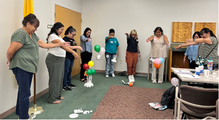
A drone team out of NASA Langley conducted eight data-collection flights in Missoula. Before each drone flight, student teams from the University of Idaho in Moscow, Idaho, and Salish Kootenai College in Pablo, Montana, launched a weather balloon carrying the same type of radiometer.
Left: Weather balloon teams from University of Idaho and Salish Kootenai College prepare a weather balloon for launch on the second day of the FireSense campaign in Missoula. Right: NASA Langley drone crew members Todd Ferrante (left) and Brayden Chamberlain (right) calibrate the internal sensors of the NASA Alta X quadcopter before its first test flight on Aug. 27, 2024.
Once those data sets were created, they needed to be transformed into a usable format. Meteorologists are used to the numbers, but incident commanders on an active fire need to see the data in a form that allows them to quickly understand which conditions are changing, and how. That’s where data visualization partners come in. For the Missoula campaign, teams from MITRE, NVIDIA, and Esri joined NASA in the field.
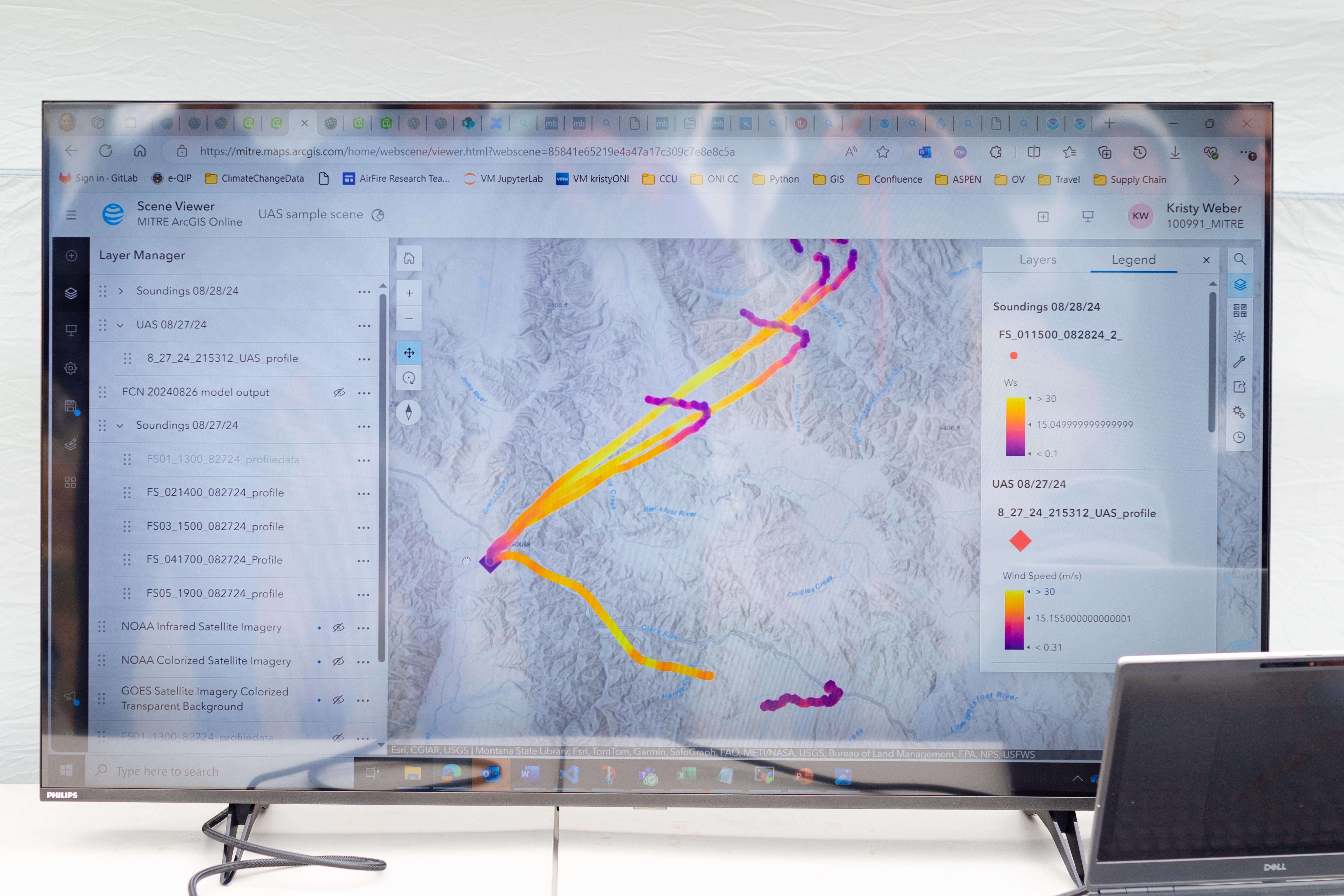
An early data visualization from the Esri team shows the flight paths of weather balloons launched on the first day of the FireSense UAS technology demonstration in Missoula. The paths are color-coded by wind speed, from purple (low wind) to bright yellow (high wind).
NASA/Milan Loiacono
Measurements from both the balloon and the drone platforms were immediately sent to the on-site data teams. The MITRE team, together with NVIDIA, tested high-resolution artificial intelligence meteorological models, while the Esri team created comprehensive visualizations of flight paths, temperatures, and wind speed and direction. These visual representations of the data make conclusions more immediately apparent to non-meteorologists.
What’s Next?
Development of drone capabilities for fire monitoring didn’t begin in Missoula, and it won’t end there.
“This campaign leveraged almost a decade of research, development, engineering, and testing,” said McSwain. “We have built up a UAS flight capability that can now be used across NASA.”
This campaign leveraged almost a decade of research, development, engineering, and testing. We have built up a UAS flight capability that can now be used across NASA.
Robert Mcswain
FireSense Uncrewed Aerial System (UAS) Lead
The NASA Alta X and its sensor payload will head to Alabama and Florida in spring 2025, incorporating improvements identified in Montana. There, the team will perform another technology demonstration with wildland fire managers from a different region.
The FireSense project is led by NASA Headquarters in Washington and sits within the Wildland Fires program, with the project office based at NASA Ames. The goal of FireSense is to transition Earth science and technological capabilities to operational wildland fire management agencies, to address challenges in U.S. wildland fire management before, during, and after a fire.
About the Author
Milan Loiacono
Science Communication Specialist
Milan Loiacono is a science communication specialist for the Earth Science Division at NASA Ames Research Center.
Gov. Gavin Newsom plans to stage a photo-op Tuesday afternoon to mark the start of debris removal after the Palisades Fire -- even though the state government has little to do with it.
Steve Hagerty, the founder of Hagerty Consulting, which Los Angeles Mayor Karen Bass chose behind closed doors to lead the city's rebuilding effort, had a disastrous tenure as mayor of the liberal college town of Evanston, Illinois.
Developer Rick Caruso slammed the Los Angeles city government for an apparent delay in construction at a venue that is to be used during the 2028 Summer Olympics that officials are blaming on the recent Palisades Fire.
Two former disaster recovery experts at Hagerty Consulting, which L.A. Mayor Karen Bass appointed to lead rebuilding efforts after the recent wildfires, pleaded guilty in 2022 and 2023 to defrauding New York City of Hurricane Sandy relief funds.
Sen. Adam Schiff, D-Calif., called on multiple federal agencies to exempt federal seasonal firefighters from President Donald Trump's executive order implementing a federal hiring freeze.
In a letter to the Department of Agriculture, the Department of the Interior and the Office of Management and Budget, Schiff noted that Trump's hiring freeze issued on Jan. 20 had stopped the onboarding of thousands of seasonal firefighters that could harm readiness to respond to wildfires, as Southern California is still grappling with the aftermath of last month's wildfires.
"The memo issued on January 20 states that it does not apply to positions related to public safety, but this onboarding delay is directly contrary to that claim," Schiff said in the letter dated Friday. "Our constituents and communities rely on the hard work and sacrifice of our more than 15,000 seasonal federal wildland firefighters each year."
"Seasonal firefighters are essential to the public safety of those who live in fire-prone areas, and I am alarmed that federal firefighters are not party to this exemption," he said. "In light of this, I am requesting information from your agencies explaining why the federal hiring freeze has extended to the hiring of seasonal federal wildland firefighters."
Southern California was devastated last month by two major wildfires and several smaller ones that killed nearly 30 people and destroyed more than 16,000 structures.
Some of the firefighters subject to Trump's order that halted the onboarding of thousands of seasonal federal firefighters were from agencies that helped in the response to the wildfires in the Los Angeles area, according to NBC News.
A Bureau of Land Management official told the outlet that despite Trump's order excluding positions related to "public safety" from the hiring freeze, federal firefighters are not exempt.
"In the face of increasingly destructive wildfires, we cannot afford to diminish the tools at our disposal to fight these fires," Schiff said in his letter. "Impeding the onboarding of federal firefighters and encouraging the early retirement of others, threatens California’s firefighting capacity and puts communities at great risk. Californians rely on the support of federal firefighters, and I hope you share my appreciation for the essential role these individuals play in keeping residents safe."
The senator also requested information on how the hiring freeze impacts federal firefighting applicants, the number of voluntary resignations and the Elon Musk-led Department of Government Efficiency's role in the hiring, preparedness or readiness of federal wildland firefighters.
Los Angeles "Chief Recovery Officer" Steve Soboroff said Saturday night that he would work for free, after coming under fire for earning $500,000 for three months of work, even though his salary was to have been paid privately.
Jacob Soboroff, a familiar face on MSNBC and NBC's political and national correspondent, has a deeply personal connection to the Palisades Fire: he grew up in town, and is the son of L.A. "Chief Recovery Officer" Steve Soboroff.
A local mother whose neighborhood was destroyed in the Palisades Fire is fighting back after the New York Times smeared Pacific Palisades residents as the "rogue rich" who are exploiting the disaster to buy up the lots of their neighbors.
Los Angeles Mayor Karen Bass (D) has brought in an Illinois consulting firm headed by a far-left politician who took part in a George Soros-funded mayors' program, appointed his city's first chief equity officer, and signed a resolution to recognize that his city's land was stolen from Native Americans by "white colonizers" to help the post-fire recovery process.
California Gov. Gavin Newsom (D) signed two bills providing $50 million to fight President Donald Trump's policies -- after returning from a trip to Washington, DC, where he sought federal aid money for recent wildfires in his state.
California Gov. Gavin Newsom (D) plans to ban the use of plants within five feet of residential homes in what are designated as "fire-prone" areas -- which could include much of the state of California, given the recent wildfires.
The right thing to do -- the manly thing, if one can still say that -- would be for Newsom to veto the $50 million and concede that maybe now is not the time to be poking President Donald Trump and federal taxpayers in the eye.