Actress Hannah Einbinder -- who stars in the HBO Max series "Hacks" -- delivered a climate change lecture during her acceptance speech at the Critics Choice Awards in Santa Monica on Friday, pointing the finger of blame directly at oil and gas companies.
The once illustrious Lancet medical journal is in full meltdown over Donald Trump’s repudiation of its favorite ideological projects, such as climate alarmism, global abortion funding, and “gender diversity.”
Climate change will result in an estimated 2.3 million additional temperature-related deaths in Europe by 2099, according to researchers led by a London-based climate-modeling group.
Officials and business executives at the annual gathering in Switzerland said the fight against global climate change would continue with or without the United States.
Los Angeles Times columnist Sammy Roth, who opposed Rick Caruso for mayor in 2022 because he said Caruso had no "climate plan," has blamed "climate change" for the Palisades Fire and other fires that have devastated the city.
CNN senior political data reporter Harry Enten said Monday on "News Central" that Americans don't understand the connection between climate change and wildfires.
California’s leaders are “charlatans and empty suits” for neglecting infrastructure and embracing performative politics, according to world-renowned historian and political commentator Dr. Victor Davis Hanson, who exposed policy failures he says have turned Los Angeles into a burning wasteland, comparing the city’s devastation to the World War II firebombing of Dresden.
Green radicals from the Just Stop Oil activist collective defaced Charles Darwin's grave on Monday, claiming that humanity will not be able to adapt to the supposed climate crisis.
Democrat Massachusetts Sen. Ed Markey claimed the Los Angeles fires are the result of a climate change "disaster" stoked by President-elect Donald Trump's embrace of "Big Oil" — and there is more "death" coming as a result.
Preparations for Next Moonwalk Simulations Underway (and Underwater)
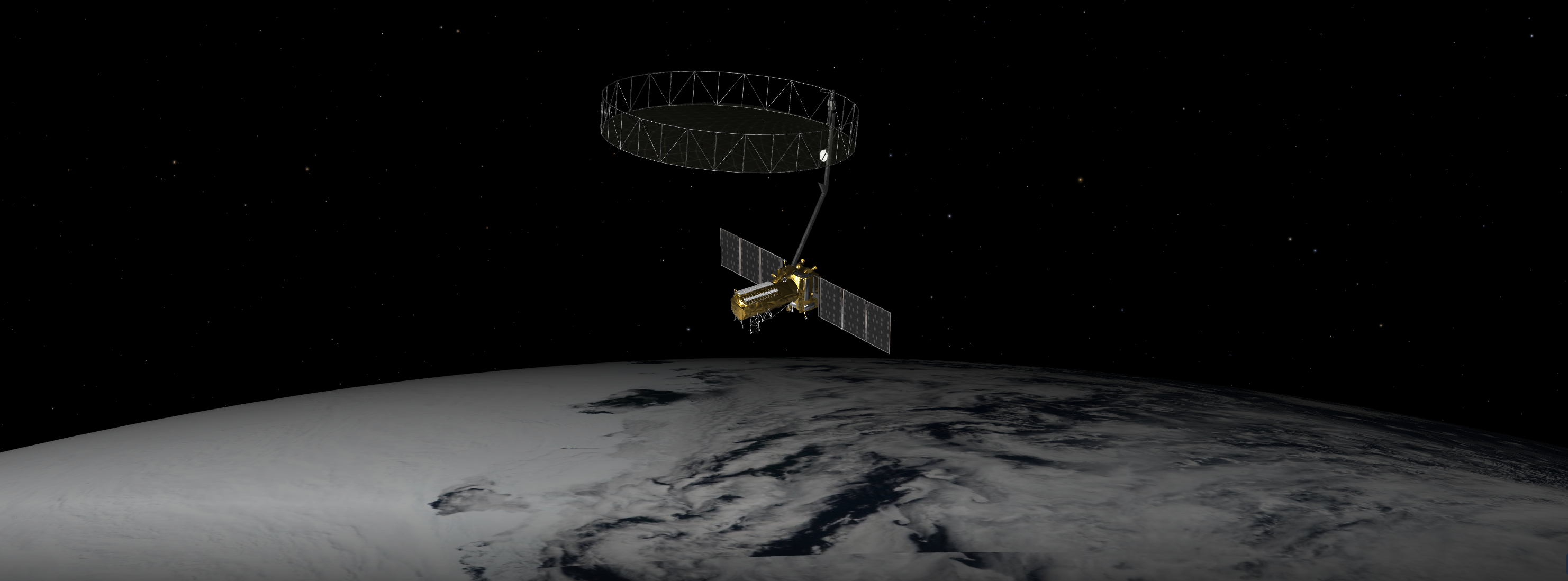
An equal collaboration between NASA and the Indian Space Research Organisation, NISAR will offer unprecedented insights into Earth’s constantly changing land and ice surfaces using synthetic aperture radar technology. The spacecraft, depicted here in an artist’s concept, will launch from India.
NASA/JPL-Caltech
A Q&A with the lead U.S. scientist of the mission, which will track changes in everything from wetlands to ice sheets to infrastructure damaged by natural disasters.
The upcoming U.S.-India NISAR (NASA-ISRO Synthetic Aperture Radar) mission will observe Earth like no mission before, offering insights about our planet’s ever-changing surface.
The NISAR mission is a first-of-a-kind dual-band radar satellite that will measure land deformation from earthquakes, landslides, and volcanoes, producing data for science and disaster response. It will track how much glaciers and ice sheets are advancing or retreating and it will monitor growth and loss of forests and wetlands for insights on the global carbon cycle.
As diverse as NISAR’s impact will be, the mission’s winding path to launch — in a few months’ time — has also been remarkable. Paul Rosen, NISAR’s project scientist at NASA’s Jet Propulsion Laboratory in Southern California, has been there at every step. He recently discussed the mission and what sets it apart.
NISAR Project Scientist Paul Rosen of NASA’s Jet Propulsion Laboratory first traveled to India in late 2011 to discuss collaboration with ISRO scientists on an Earth-observing radar mission. NASA and ISRO signed an agreement in 2014 to develop NISAR.
NASA/JPL-Caltech
How will NISAR improve our understanding of Earth?
The planet’s surfaces never stop changing — in some ways small and subtle, and in other ways monumental and sudden. With NISAR, we’ll measure that change roughly every week, with each pixel capturing an area about half the size of a tennis court. Taking imagery of nearly all Earth’s land and ice surfaces this frequently and at such a small scale — down to the centimeter — will help us put the pieces together into one coherent picture to create a story about the planet as a living system.
What sets NISAR apart from other Earth missions?
NISAR will be the first Earth-observing satellite with two kinds of radar — an L-band system with a 10-inch (25-centimeter) wavelength and an S-band system with a 4-inch (10-centimeter) wavelength.
Whether microwaves reflect or penetrate an object depends on their wavelength. Shorter wavelengths are more sensitive to smaller objects such as leaves and rough surfaces, whereas longer wavelengths are more reactive with larger structures like boulders and tree trunks.
So NISAR’s two radar signals will react differently to some features on Earth’s surface. By taking advantage of what each signal is or isn’t sensitive to, researchers can study a broader range of features than they could with either radar on its own, observing the same features with different wavelengths.
Is this new technology?
The concept of a spaceborne synthetic aperture radar, or SAR, studying Earth’s processes dates to the 1970s, when NASA launched Seasat. Though the mission lasted only a few months, it produced first-of-a-kind images that changed the remote-sensing landscape for decades to come.
Our data products will fit the needs of users across the mission’s science focus areas — ecosystems, cryosphere, and solid Earth — plus have many uses beyond basic research like soil-moisture and water resources monitoring.
We’ll make the data easily accessible. Given the volume of the data, NASA decided that it would be processed and stored in the cloud, where it’ll be free to access.
How did the ISRO partnership come about?
We proposed DESDynI (Deformation, Ecosystem Structure, and Dynamics of Ice), an L-band satellite, following the 2007 Decadal Survey by the National Academy of Sciences. At the time, ISRO was exploring launching an S-band satellite. The two science teams proposed a dual-band mission, and in 2014 NASA and ISRO agreed to partner on NISAR.
Since then, the agencies have been collaborating across more than 9,000 miles (14,500 kilometers) and 13 time zones. Hardware was built on different continents before being assembled in India to complete the satellite. It’s been a long journey — literally.
More About NISAR
The NISAR mission is an equal collaboration between NASA and ISRO and marks the first time the two agencies have cooperated on hardware development for an Earth-observing mission. Managed for the agency by Caltech, JPL leads the U.S. component of the project and is providing the mission’s L-band SAR. NASA is also providing the radar reflector antenna, the deployable boom, a high-rate communication subsystem for science data, GPS receivers, a solid-state recorder, and payload data subsystem.
Space Applications Centre Ahmedabad, ISRO’s lead center for payload development, is providing the mission’s S-band SAR instrument and is responsible for its calibration, data processing, and development of science algorithms to address the scientific goals of the mission. U R Rao Satellite Centre in Bengaluru, which leads the ISRO components of the mission, is providing the spacecraft bus. The launch vehicle is from ISRO’s Vikram Sarabhai Space Centre, launch services are through ISRO’s Satish Dhawan Space Centre, and satellite mission operations are by ISRO Telemetry Tracking and Command Network. National Remote Sensing Centre in Hyderabad is primarily responsible for S-band data reception, operational products generation, and dissemination.
This map depicts global temperature anomalies for meteorological summer in 2024 (June, July, and August). It shows how much warmer or cooler different regions of Earth were compared to the baseline average from 1951 to 1980. (Credit: NASA/NOAA)
Climate researchers from NASA and NOAA (National Oceanic and Atmospheric Administration) will release their annual assessments of global temperatures and discuss the major climate trends of 2024 during a media briefing at 12 p.m. EST Friday, Jan. 10.
Gavin Schmidt, director, NASA’s Goddard Institute for Space Studies
Russ Vose, chief, Monitoring and Assessment Branch, NOAA National Centers for Environmental Information
Media interested in participating must RSVP to NOAA by the time of the event.
NASA and NOAA are stewards of global temperature data and independently produce a record of Earth’s surface temperatures and changes based on historical observations over land and ocean.
For more information about NASA’s Earth science programs, visit: