NASA astronaut Don Pettit used a camera with low light and long duration settings to capture this Jan. 29, 2025, image of the Milky Way appearing beyond Earth’s horizon. At the time, the International Space Station was orbiting 265 miles above the Pacific Ocean off the coast of Chile just before sunrise.
Pettit is part of the Expedition 72 crew, along with NASA astronauts Suni Williams, Butch Wilmore, and Nick Hague. The orbital residents are exploring a variety of space phenomena to benefit humans on and off the Earth including pharmaceutical manufacturing, advanced life support systems, genetic sequencing in microgravity, and more.
Preparations for Next Moonwalk Simulations Underway (and Underwater)
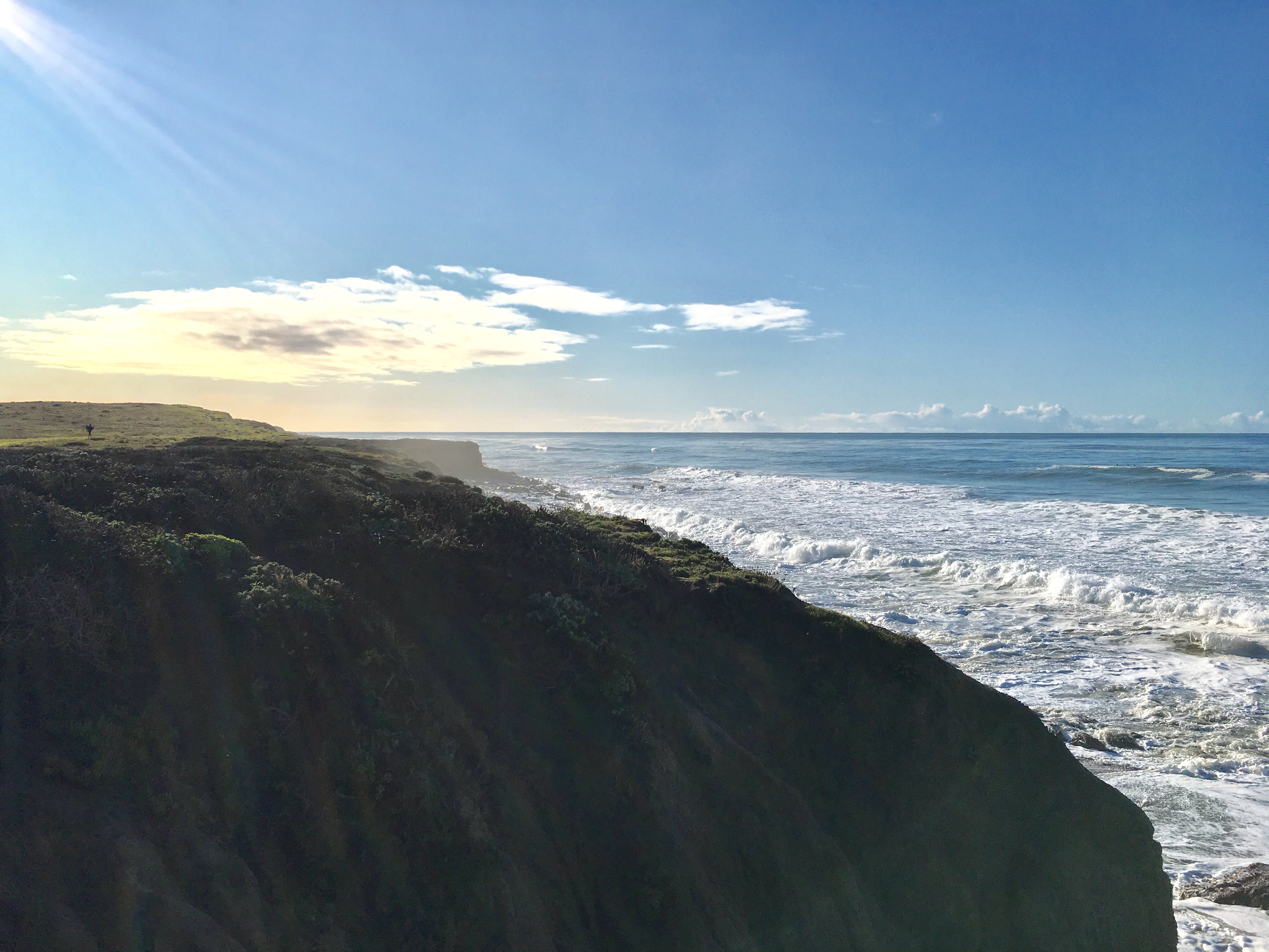
Cliffs slope into the ocean in San Simeon, California. All along the state’s dynamic coastline, land is inching down and up due to natural and human-caused factors. A better understanding of this motion can help communities prepare for rising seas.
NASA/JPL-Caltech
The elevation changes may seem small — amounting to fractions of inches per year — but they can increase or decrease local flood risk, wave exposure, and saltwater intrusion.
Tracking and predicting sea level rise involves more than measuring the height of our oceans: Land along coastlines also inches up and down in elevation. Using California as a case study, a NASA-led team has shown how seemingly modest vertical land motion could significantly impact local sea levels in coming decades.
By 2050, sea levels in California are expected to increase between 6 and 14.5 inches (15 and 37 centimeters) higher than year 2000 levels. Melting glaciers and ice sheets, as well as warming ocean water, are primarily driving the rise. As coastal communities develop adaptation strategies, they can also benefit from a better understanding of the land’s role, the team said. The findings are being used in updated guidance for the state.
“In many parts of the world, like the reclaimed ground beneath San Francisco, the land is moving down faster than the sea itself is going up,” said lead author Marin Govorcin, a remote sensing scientist at NASA’s Jet Propulsion Laboratory in Southern California.
The new study illustrates how vertical land motion can be unpredictable in scale and speed; it results from both human-caused factors such as groundwater pumping and wastewater injection, as well as from natural ones like tectonic activity. The researchers showed how direct satellite observations can improve estimates of vertical land motion and relative sea level rise. Current models, which are based on tide gauge measurements, cannot cover every location and all the dynamic land motion at work within a given region.
Local Changes
Researchers from JPL and the National Oceanic and Atmospheric Administration (NOAA) used satellite radar to track more than a thousand miles of California coast rising and sinking in new detail. They pinpointed hot spots — including cities, beaches, and aquifers — at greater exposure to rising seas now and in coming decades.
To capture localized motion inch by inch from space, the team analyzed radar measurements made by ESA’s (the European Space Agency’s) Sentinel-1 satellites, as well as motion velocity data from ground-based receiving stations in the Global Navigation Satellite System. Researchers compared multiple observations of the same locations made between 2015 to 2023 using a processing technique called interferometric synthetic aperture radar (InSAR).
Scientists mapped land sinking (indicated in blue) in coastal California cities and in parts of the Central Valley due to factors like soil compaction, erosion, and groundwater withdrawal. They also tracked uplift hot spots (shown in red), including in Long Beach, a site of oil and gas production.
NASA Earth Observatory
Homing in on the San Francisco Bay Area — specifically, San Rafael, Corte Madera, Foster City, and Bay Farm Island — the team found the land subsiding at a steady rate of more than 0.4 inches (10 millimeters) per year due largely to sediment compaction. Accounting for this subsidence in the lowest-lying parts of these areas, local sea levels could rise more than 17 inches (45 centimeters) by 2050. That’s more than double the regional estimate of 7.4 inches (19 centimeters) based solely on tide gauge projections.
Not all coastal locations in California are sinking. The researchers mapped uplift hot spots of several millimeters per year in the Santa Barbara groundwater basin, which has been steadily replenishing since 2018. They also observed uplift in Long Beach, where fluid extraction and injection occur with oil and gas production.
The scientists further calculated how human-induced drivers of local land motion increase uncertainties in the sea level projections by up to 15 inches (40 centimeters) in parts of Los Angeles and San Diego counties. Reliable projections in these areas are challenging because the unpredictable nature of human activities, such as hydrocarbon production and groundwater extraction, necessitating ongoing monitoring of land motion.
Fluctuating Aquifers, Slow-Moving Landslides
In the middle of California, in the fast-sinking parts of the Central Valley (subsiding as much as 8 inches, or 20 centimeters, per year), land motion is influenced by groundwater withdrawal. Periods of drought and precipitation can alternately draw down or inflate underground aquifers. Such fluctuations were also observed over aquifers in Santa Clara in the San Francisco Bay Area, Santa Ana in Orange County, and Chula Vista in San Diego County.
Along rugged coastal terrain like the Big Sur mountains below San Francisco and Palos Verdes Peninsula in Los Angeles, the team pinpointed local zones of downward motion associated with slow-moving landslides. In Northern California they also found sinking trends at marshlands and lagoons around San Francisco and Monterey bays, and in Sonoma County’s Russian River estuary. Erosion in these areas likely played a key factor.
Scientists, decision-makers, and the public can monitor these and other changes occurring via the JPL-led OPERA (Observational Products for End-Users from Remote Sensing Analysis) project. The OPERA project details land surface elevational changes across North America, shedding light on dynamic processes including subsidence, tectonics, and landslides.
The OPERA project will leverage additional state-of-the-art InSAR data from the upcoming NISAR (NASA-Indian Space Research Organization Synthetic Aperture Radar) mission, expected to launch within the coming months.
NASA and European scientists explain how they calculate the probability of the space rock 2024 YR4 impacting our planet, and why it’s not yet time to worry.
Pine cones have these amazing scales that respond to moisture. When it's damp, they close up tight. But when it's warm and dry, they open wide to release their seeds. This simple yet effective mechanism has inspired scientists to develop a smart window system that could change the way we think about energy efficiency in buildings.
Scientists from Germany's universities of Stuttgart and Freiburg have developed what is known as the Solar Gate window facade system. It's like having tiny pinecones built right into your windows. These smart windows have special elements that curl up when it's cool and moist, letting in sunlight to warm your home. But when it's hot and dry, they flatten out to block the sun and keep things cool inside.
The Solar Gate system consists of a gridded array of pine-cone-scale-inspired self-bending elements housed between two panes of glass in an aluminum-frame window unit. Each element is ingeniously crafted with three distinct layers, each serving a unique purpose. The bottom layer is composed of a cellulose powder and a thermoplastic blend that swells when exposed to moisture. Above this lies a middle layer made of thermoplastic, which remains unaffected by moisture.
The top layer consists of flexible biocomposite filaments that serve to hold the entire structure together. When exposed to moist air, the bottom layer expands, causing the element to curl upwards. Conversely, in dry conditions, it returns to its flattened state. This simple yet effective mechanism allows the window to respond automatically to changing weather conditions, providing optimal shading and light penetration as needed.
The Solar Gate system underwent rigorous real-world testing to prove its effectiveness. In a comprehensive year-long study, researchers installed 424 Solar Gate elements in the south-facing skylight of a research building at the University of Freiburg. The results of this extensive trial were nothing short of impressive.
During the cool, wet winter months, the elements responded by curling upwards, allowing ample sunlight to penetrate the building. This natural response effectively warmed and illuminated the interior spaces, reducing the need for artificial heating and lighting. Conversely, as the seasons changed and brought warmer, drier summer conditions, the elements automatically flattened out.
This flattening action served to block excess sunlight, effectively keeping the building's interior cool and comfortable without the need for energy-intensive air conditioning. The test demonstrated the system's ability to autonomously adapt to changing weather conditions, providing optimal comfort and energy efficiency throughout the year.
This innovative approach to building technology has far-reaching implications beyond just window systems. Researchers have already begun exploring similar biomimetic principles in a variety of applications. For instance, studies have investigated the development of shading systems using wooden slats that can open and close in response to environmental conditions.
In the realm of textiles, scientists are working on "smart" clothing fabrics that can adapt to ambient temperature, providing optimal comfort for wearers. Perhaps most intriguingly, these principles are even being applied to the field of robotics, with researchers developing tiny mobile robots that can respond to environmental stimuli in ways inspired by natural mechanisms. As we continue to draw inspiration from nature's ingenious designs, the potential for creating more sustainable and responsive technologies seems boundless.
Nature never ceases to amaze us with its ingenious solutions, and the Solar Gate window system is a brilliant example of how we can harness these natural wonders. By mimicking the pinecone, scientists have created a game-changing technology that could revolutionize how we approach energy efficiency in our buildings. It's exciting to think about a future where our homes and offices adapt to the environment just like living organisms do. Who knew that the key to smarter buildings was hiding in our forests all along?
Would you feel comfortable having windows that automatically open and close based on moisture and temperature — without any electrical controls? Let us know by writing us at Cyberguy.com/Contact.
For more of my tech tips and security alerts, subscribe to my free CyberGuy Report Newsletter by heading to Cyberguy.com/Newsletter.
Are you ready to share the road with massive semi-trucks cruising down the highways next to you without a human driver? Well, that is one step closer, thanks to the groundbreaking partnership between Kodiak Robotics and Atlas Energy Solutions. These innovative companies have just pulled off something incredible. They successfully launched the first-ever commercial driverless trucking operation.
Kodiak Robotics has become the first company globally to deliver a driverless semi-truck to a customer while also being the first to generate ongoing revenue from driverless trucks. Atlas Energy Solutions, in turn, has made history as the first customer to launch a commercial delivery operation using driverless semi-trucks.
Don Burnette, founder and CEO of Kodiak Robotics, tells CyberGuy, "Through this partnership, we are providing a critical service to Atlas, helping them to provide freight service in one of America’s most difficult trucking environments."
Atlas has successfully completed 100 loads of proppant sand deliveries using Kodiak RoboTrucks, establishing itself as the pioneer in making driverless deliveries with its own autonomous fleet. The operations span the 75,000 square mile Permian Basin in West Texas and Eastern New Mexico, showcasing the scalability and efficiency of the technology.
Burnette emphasized that "before launching driverless service, we completed our safety case – Kodiak’s comprehensive study that demonstrates the safety of our self-driving system – for work in the Permian Basin."
The high demand in the Permian Basin is driving rapid scaling of operations, enabling Kodiak to earn significant revenue from its RoboTrucks faster than any other autonomous truck company. This accelerated growth demonstrates the commercial viability of autonomous trucking technology.
"We are now working to extend the safety case to highways over the course of 2025," Burnette said. "This large-scale operation allows us to rapidly accumulate driverless experience, which will benefit our on-highway customers and contribute to the successful launch of our on-highway driverless operations. We believe we have a 12- to 18-month lead on launching driverless semi-trucks at scale."
Concurrent with the RoboTruck operations, Atlas has launched the Dune Express, a 42-mile autonomous conveyor belt in the desert that delivers sand to the autonomous RoboTrucks. This integration of the RoboTrucks and the Dune Express is a key component of Atlas' strategy to automate its entire supply chain, promising increased efficiency and safety in industrial logistics.
The autonomous trucking industry stands on the brink of a transformative era, with pioneering companies like Kodiak Robotics leading the charge toward a more efficient and technologically advanced transportation landscape.
"We are encouraged by Transportation Secretary Sean Duffy’s strong commitment to creating a national regulatory framework for autonomous vehicles and are confident the new administration will ensure a clear path for innovators," Burnette said. "Ultimately, autonomous trucks will increase American competitiveness, reduce inflation, and help ensure U.S. technology leads in the 21st century. All indications suggest the industry expects the Trump administration to be favorable toward autonomous trucking. We are committed to maintaining American leadership in realizing this vision."
The partnership between Kodiak Robotics and Atlas Energy Solutions represents a pivotal moment in the transportation industry. By successfully deploying autonomous trucks in commercial operations, they have proven the technology's readiness, as well as its economic viability. This breakthrough is likely to accelerate the adoption of autonomous trucking across various sectors, potentially reshaping the future of logistics and supply chain management.
Would you feel comfortable sharing the highway with a driverless semi-truck? Let us know by writing us atCyberguy.com/Contact.
For more of my tech tips and security alerts, subscribe to my free CyberGuy Report Newsletter by heading to Cyberguy.com/Newsletter.
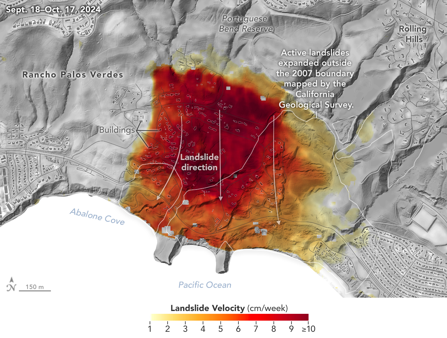
NASA’s UAVSAR airborne radar instrument captured data in fall 2024 showing the motion of landslides on the Palos Verdes Peninsula following record-breaking rainfall in Southern California in 2023 and another heavy-precipitation winter in 2024. Darker red indicates faster motion.
NASA Earth Observatory
Analysis of data from NASA radar aboard an airplane shows that the decades-old active landslide area on the Palos Verdes Peninsula has expanded.
Researchers at NASA’s Jet Propulsion Laboratory in Southern California used data from an airborne radar to measure the movement of the slow-moving landslides on the Palos Verdes Peninsula in Los Angeles County. The analysis determined that, during a four-week period in the fall of 2024, land in the residential area slid toward the ocean by as much as 4 inches (10 centimeters) per week.
Portions of the peninsula, which juts into the Pacific Ocean just south of the city of Los Angeles, are part of an ancient complex of landslides and has been moving for at least the past six decades, affecting hundreds of buildings in local communities. The motion accelerated, and the active area expanded following record-breaking rainfall in Southern California in 2023 and heavy precipitation in early 2024.
To create this visualization, the Advanced Rapid Imaging and Analysis (ARIA) team used data from four flights of NASA’s Uninhabited Aerial Vehicle Synthetic Aperture Radar (UAVSAR) that took place between Sept. 18 and Oct. 17. The UAVSAR instrument was mounted to a Gulfstream III jet flown out of NASA’s Armstrong Flight Research Center in Edwards, California, and the four flights were planned to estimate the speed and direction of the landslides in three dimensions.
In the image above, colors indicate how fast parts of the landslide complex were moving in late September and October, with the darkest reds indicating the highest speeds. The arrows represent the direction of horizontal motion. The white solid lines are the boundaries of the active landslide area as defined in 2007 by the California Geological Survey.
“In effect, we’re seeing that the footprint of land experiencing significant impacts has expanded, and the speed is more than enough to put human life and infrastructure at risk,” said Alexander Handwerger, the JPL landslide scientist who performed the analysis.
The insights from the UAVSAR flights were part of a package of analyses by the ARIA team that also used data from ESA’s (the European Space Agency’s) Copernicus Sentinel-1A/B satellites. The analyses were provided to California officials to support the state’s response to the landslides and made available to the public at NASA’s Disaster Mapping Portal.
Handwerger is also the principal investigator for NASA’s upcoming Landslide Climate Change Experiment, which will use airborne radar to study how extreme wet or dry precipitation patterns influence landslides. The investigation will include flights over coastal slopes spanning the California coastline.
More About ARIA, UAVSAR
The ARIA mission is a collaboration between JPL and Caltech, which manages JPL for NASA, to leverage radar and optical remote-sensing, GPS, and seismic observations for science as well as to aid in disaster response. The project investigates the processes and impacts of earthquakes, volcanoes, landslides, fires, subsurface fluid movement, and other natural hazards.
UAVSAR has flown thousands of radar missions around the world since 2007, studying phenomena such as glaciers and ice sheets, vegetation in ecosystems, and natural hazards like earthquakes, volcanoes, and landslides.
Sony has officially entered the electric vehicle (EV) market with its new model, the Afeela 1. This innovative vehicle, developed in partnership with Honda, aims to redefine the driving experience by integrating advanced technology and entertainment features. Unveiled at CES 2025, the Afeela 1 is now available for preorder, marking a significant milestone in Sony's expansion beyond consumer electronics into the automotive industry.
Equipped with a powerful 482 hp all-wheel-drive powertrain, the Afeela 1 features a 91 kWh battery that offers an EPA-estimated range of 300 miles. It supports fast charging at 150 kW and is compatible with Tesla's Supercharger network, providing convenience for long-distance travel.
The Afeela 1 boasts an impressive array of 40 sensors and cameras, enabling Level 2+ ADAS features. These systems include lidar assistance for tasks like automated parking and real-time environmental monitoring. The vehicle's AI processing capabilities allow it to perform up to 800 trillion operations per second, paving the way for future updates that may enhance its autonomous driving capabilities.
The design of the Afeela 1 focuses on comfort and aesthetics. Its interior is crafted from high-quality materials, including plant-derived and recycled components. The cabin is optimized for entertainment, featuring strategically placed displays and noise-canceling technology to enhance the passenger experience.
The Afeela 1 is available in two trims: the Origin, which starts at $89,900, and the Signature, priced at $102,900. Currently, preorders are open exclusively for California residents, requiring a refundable reservation fee of $200. The Signature variant is expected to ship in mid-2026, while the Origin will follow in 2027.
Sony's entry into the electric vehicle market with the Afeela 1 represents a significant shift towards integrating technology and mobility. With its high-performance specs, advanced driver assistance systems and focus on entertainment, it aims to appeal to tech-savvy consumers looking for more than just transportation.
What features are most important in an electric vehicle, and how will that affect your decision to purchase one? Let us know what you think by writing us atCyberguy.com/Contact.
For more of my tech tips and security alerts, subscribe to my free CyberGuy Report Newsletter by heading to Cyberguy.com/Newsletter.
Home security-camera footage shows a puff of smoke, with the sound of an explosion included, as the space rock lands in Canada. A geologist said it was a rare recording.
NASA International Space Apps Challenge Announces 2024 Global Winners
The 2024 NASA Space Apps Challenge was hosted at 485 events in 163 countries and territories.
Credits: NASA
NASA Space Apps has named 10 global winners, recognizing teams from around the world for their exceptional innovation and collaboration during the 2024 NASA Space Apps Challenge. As the largest annual global hackathon, this event invites participants to leverage open data from NASA and its space agency partners to tackle real-world challenges on Earth and in space.
Last year’s hackathon welcomed 93,520 registered participants, including space, science, technology, and storytelling enthusiasts of all ages. Participants gathered at local events in 163 countries and territories, forming teams to address the challenges authored by NASA subject matter experts. These challenges included subjects/themes/questions in ocean ecosystems, exoplanet exploration, Earth observation, planetary seismology, and more.
The 2024 Global Winners were determined out of 9,996 project submissions and judged by subject matter experts from NASA and space agency partners.
“These 10 exceptional teams created projects that reflect our commitment to understanding our planet and exploring beyond, with the potential to transform Earth and space science for the benefit of all,” said Dr. Keith Gaddis, NASA Space Apps Challenge program scientistat NASA Headquarters in Washington. “The NASA Space Apps Challenge showcases the potential of every idea and individual. I am excited to see how these innovators will shape and inspire the future of science and exploration.”
You can watch the Global Winners Announcement here to meet these winning teams and learn about the inspiration behind their projects.
2024 NASA Space Apps Challenge Global Winners
Best Use of Science Award: WMPGang
Team Members: Dakota C., Ian C., Maximilian V., Simon S.
Challenge: Create an Orrery Web App that Displays Near-Earth Objects
Country/Territory: Waterloo,Canada
Using their skills in programming, data analysis, and visualization, WMPGang created a web app that identifies satellite risk zones using real-time data on Near-Earth Objects and meteor streams.
Team Members: Aakash H., Arun G., Arthur A., Gabriel A., May K.
Challenge: Leveraging Earth Observation Data for Informed Agricultural Decision-Making
Country/Territory: Universal Event, United States
GaamaRamma’s team of tech enthusiasts aimed to create a sustainable way to help farmers efficiently manage water availability in the face of drought, pests, and disease.
Team Members: Alailton A., Ana B., Gabriel C., Gustavo M., Gustavo T., Larissa M.
Challenge: Seismic Detection Across the Solar System
Country/Territory: Maceió, Brazil
Team 42 QuakeHeroes employed a deep neural network model to identify the precise locations of seismic events within time-series data. They used advanced signal processing techniques to isolate and analyze unique components of non-stationary signals.
Team Members: Oksana M., Oleksandra M., Prokipchyn Y., Val K.
Challenge: Leveraging Earth Observation Data for Informed Agricultural Decision-Making
Country/Territory: Kyiv, Ukraine
The NVS-knot team assessed planting conditions using surface soil moisture and evapotranspiration data, then created an app that empowers farmers to manage planting risks.
Team Members: Coral M., Daniel C., Daniel V., Juan B., Samuel G., Vladimir C.
Challenge: Landsat Reflectance Data: On the Fly and at Your Fingertips
Country/Territory: Gijón, Spain
AsturExplorers created Landsat Connect, a web app that provides a simple, intuitive way to track Landast satellites and access Landsat surface reflectance data. The app also allows users to set a target location and receive notifications when Landsat satellites pass over their area.
Team Members: Rikzah K., Samira K., Shafeeqa J., Umamah A.
Challenge: SDGs in the Classroom
Country/Territory: Sharjah, United Arab Emirates
Innovisionaries developed Eco-Metropolis to inspire sustainability through gameplay. This city-building game engages players in making critical urban planning and resource management decisions based on real-world environmental data.
Team Members: Ahmed R., Fatma E., Habiba A., Judy A., Maya M.
Challenge: Tell Us a Climate Story!
Country/Territory: Cairo, Egypt
TerraTales shared stories of how Earth’s changing climate affects three unique regions: Egypt, Brazil, and Germany. The web app also features an artificial intelligence (AI) model for climate forecasting and an interactive game to encourage users to make eco-friendly choices.
Team Members: Kapeesh K., Khoi N., Sathyajit L., Satyam S.
Challenge: Navigator for the Habitable Worlds Observatory (HWO): Mapping the Characterizable Exoplanets in our Galaxy
Country/Territory: Saskatoon, Canada
Team Asteroid Destroyer honed in on exoplanets, utilizing data processing and machine learning techniques to map exoplanets based on size, temperature, and distance.
Team Members: Gabriel M., Luc R., Lucas R., Mattheus L., Pedro C., Riccardo S.
Challenge: Imagine our Connected Earth
Country/Territory: Campinas, Brazil
Team Connected Earth Museum created an immersive virtual museum experience to raise awareness of Earth’s changing climate. An AI host guides users through an interactive gallery featuring 3D and 2D visualizations, including a time series on Earth and ocean temperatures, population density, wildfires, and more.
Team Members: Frank R., Jan K., Raphael R., Ryan Z., Victoria M.
Challenge: Community Mapping
Country/Territory: Florianópolis, Brazil
Team I.O. bridges the gap between complex Geographic Information Systems data and user-friendly communication, making critical environmental information accessible to everyone, regardless of technical expertise.
Want to take part in the 2025 NASA Space Apps Challenge? Mark your calendars for October 4 and 5! Registration will open in July. At that time, participants will be able to register for a local event hosted by NASA Space Apps leads from around the world. You can stay connected with NASA Space Apps on Facebook, Instagram, and X.
NASA Scientists Find New Human-Caused Shifts in Global Water Cycle
Cracked mud and salt on the valley floor in Death Valley National Park in California can become a reflective pool after rains. (File photo)
Credits: NPS/Kurt Moses
In a recently published paper, NASA scientists use nearly 20 years of observations to show that the global water cycle is shifting in unprecedented ways. The majority of those shifts are driven by activities such as agriculture and could have impacts on ecosystems and water management, especially in certain regions.
“We established with data assimilation that human intervention in the global water cycle is more significant than we thought,” said Sujay Kumar, a research scientist at NASA’s Goddard Space Flight Center in Greenbelt, Maryland, and a co-author of the paper published in the Proceedings of the National Academy of Sciences.
The shifts have implications for people all over the world. Water management practices, such as designing infrastructure for floods or developing drought indicators for early warning systems, are often based on assumptions that the water cycle fluctuates only within a certain range, said Wanshu Nie, a research scientist at NASA Goddard and lead author of the paper.
“This may no longer hold true for some regions,” Nie said. “We hope that this research will serve as a guide map for improving how we assess water resources variability and plan for sustainable resource management, especially in areas where these changes are most significant.”
One example of the human impacts on the water cycle is in North China, which is experiencing an ongoing drought. But vegetation in many areas continues to thrive, partially because producers continue to irrigate their land by pumping more water from groundwater storage, Kumar said. Such interrelated human interventions often lead to complex effects on other water cycle variables, such as evapotranspiration and runoff.
Nie and her colleagues focused on three different kinds of shifts or changes in the cycle: first, a trend, such as a decrease in water in a groundwater reservoir; second, a shift in seasonality, like the typical growing season starting earlier in the year, or an earlier snowmelt; and third a change in extreme events, like “100-year floods” happening more frequently.
The scientists gathered remote sensing data from 2003 to 2020 from several different NASA satellite sources: the Global Precipitation Measurement mission satellite for precipitation data, a soil moisture dataset from the European Space Agency’s Climate Change Initiative, and the Gravity Recovery and Climate Experiment satellites for terrestrial water storage data. They also used products from the Moderate Resolution Imaging Spectroradiometer satellite instrument to provide information on vegetation health.
“This paper combines several years of our team’s effort in developing capabilities on satellite data analysis, allowing us to precisely simulate continental water fluxes and storages across the planet,” said Augusto Getirana, a research scientist at NASA Goddard and a co-author of the paper.
The study results suggest that Earth system models used to simulate the future global water cycle should evolve to integrate the ongoing effects of human activities. With more data and improved models, producers and water resource managers could understand and effectively plan for what the “new normal” of their local water situation looks like, Nie said.
By Erica McNamee NASA’s Goddard Space Flight Center, Greenbelt, Maryland
AC Future, a leading developer of AI-enabled sustainable living solutions, has partnered with world-renowned Italian design house Pininfarina to create a groundbreaking collection of transformable living spaces. This innovative collaboration has resulted in three distinct products: AI-THd (AI Transformer Home Drivable), AI-THu (AI Transformer Home Unit) and AI-THt (AI Transformer Home Trailer).
The AI-THd is an intelligent, self-sufficient, drivable version of the AI Transformer Home that provides unprecedented mobility and flexibility. Drivers can expand the vehicle from a compact recreational vehicle into a large mobile living space with remarkable ease. The innovative design allows the cockpit to convert into a mobile office or secondary bedroom, creating a versatile living environment. Advanced AI-enabled smart technologies enhance the overall living experience, supporting a range of lifestyle needs and preferences.
The AI-THu represents a stationary AI-enabled sustainable smart home that transforms to offer 400 square feet of intelligent living space. Its flexible main living area can seamlessly shift between a comfortable lounge, productive office or additional bedroom, maximizing functional utility. The design includes a convertible front expansion for additional living space and a private primary bedroom with extendable wardrobe options. Integrated AI smart home technology, solar panels, energy storage systems and a water generator ensure sustainable and efficient living. Priced starting at $98,000, the AI-THu can be installed anywhere – on-grid or off-grid – while maintaining the comforts of a traditional home.
The AI-THt is a 24-foot-long transformer home trailer that expands to offer up to 400 square feet of sophisticated internal living space. Utilizing patented expansion living technologies, this trailer provides flexible living spaces that adapt to various lifestyle needs. Smart AI enhancements and an aerodynamic design distinguish the AI-THt from traditional trailer homes. The unique construction eliminates the need for a front driving cabin, resulting in a more premium and spacious interior environment that doubles in size when fully expanded.
All three AI-TH products exemplify a commitment to cutting-edge engineering, sustainable innovation and refined design. They push the boundaries of conventional standards and elevate the concept of adaptable living. Francisco Barboza, Pininfarina's senior design manager, emphasizes the challenge of maintaining an efficient floor plan while accommodating complex opening systems, resulting in an iconic design that authentically embraces the future.
The AI-THd, AI-THu and AI-THt are more than just innovative products. They're like a crystal ball showing us how we might live, work and explore the world without compromising our environment. AC Future and Pininfarina aren't just thinking outside the box. They're creating an entirely new box. Or should we say, an expandable, AI-powered, eco-friendly box on wheels? Their partnership is laying the groundwork for a revolution in housing and mobility that could change the way we think about home in the future.
What worries, if any, do you have about using AI in our homes? Let us know what you think by writing us at Cyberguy.com/Contact.
For more of my tech tips and security alerts, subscribe to my free CyberGuy Report Newsletter by heading to Cyberguy.com/Newsletter.
On April 21, 1972, NASA astronaut John W. Young, commander of the Apollo 16 mission, took a far-ultraviolet photo of Earth with an ultraviolet camera. Young’s original black-and-white picture was printed on Agfacontour professional film three times, with each exposure recording only one light level. The three light levels were then colored blue (dimmest), green (next brightest), and red (brightest), resulting in the enhanced-color image seen here.
Dr. George Carruthers, a scientist at the Naval Research Laboratory, developed the ultraviolet camera – the first Moon-based observatory – for Apollo 16. Apollo 16 astronauts placed the observatory on the Moon in April 1972, where it sits today on the Moon’s Descartes highland region, in the shadow of the lunar module Orion.
Measurements from space support wildfire risk predictions
Researchers demonstrated that data from the International Space Station’s ECOsystem Spaceborne Thermal Radiometer Experiment on Space Station (ECOSTRESS) instrument played a significant role in the ability of machine learning algorithms to predict wildfire susceptibility. This result could help support development of effective strategies for predicting, preventing, monitoring, and managing wildfires.
As the frequency and severity of wildfires increases worldwide, experts need reliable models of fire susceptibility to protect public safety and support natural resource planning and risk management. ECOSTRESS measures evapotranspiration, water use efficiency, and other plant-water dynamics on Earth. Researchers report that its water use efficiency data consistently emerged as the leading factor in predicting wildfires, with evaporative stress and topographic slope data also significant.
This ECOsystem Spaceborne Thermal Radiometer Experiment on Space Station evapotranspiration image of California’s Central Valley in May 2022 shows high water use (blue) and dry conditions (brown).
NASA
Combining instruments provides better emissions data
Scientists found that averaging data from the International Space Station’s OCO‐3 and EMIT external instruments can accurately measure the rate of carbon dioxide emissions from power plants. This work could improve emissions monitoring and help communities respond to climate change.
Carbon dioxide emissions from fossil fuel combustion make up nearly a third of human-caused emissions and are a major contributor to climate change. In many places, though, scientists do not know exactly how much carbon dioxide these sources emit. The Orbiting Carbon Observatory-3 or OCO-3 can quantify emissions over large areas and Earth Surface Mineral Dust Source Investigation data can help determine emissions from individual facilities. The researchers suggest future work continue to investigate the effect of wind conditions on measurements.
The The Orbiting Carbon Observatory-3 data showing carbon dioxide concentrations in Los Angeles.
NASA
Thunderstorm phenomena observed from space
Observations by the International Space Station’s Atmosphere-Space Interactions Monitor (ASIM) instrument during a tropical cyclone in 2019 provide insight into the formation and nature of blue corona discharges often observed at the tops of thunderclouds. A better understanding of such processes in Earth’s upper atmosphere could improve atmospheric models and weather and climate predictions.
Scientists do not fully understand the conditions that lead to formation of blue corona discharges, bursts of electrical streamers, which are precursors to lightning. Observations from the ground are affected by scattering and absorption in the clouds. ASIM, a facility from ESA (European Space Agency), provides a unique opportunity for observing these high-atmosphere events from space.
View of Atmosphere-Space Interactions Monitor, the white and blue box on the end of the International Space Station’s Columbus External Payload Facility.
The Shell Starship Initiative has been on an interesting journey since its inception in 2018, with a mission to redefine energy efficiency in the commercial trucking sector. Starting with diesel engines, the first two versions of the Starship made impressive strides in fuel efficiency, but now with the introduction of the Starship 3.0, we're witnessing a remarkable shift towards sustainability. This latest iteration features the innovative Cummins X15N natural gas engine, which not only enhances performance but also significantly reduces emissions.
The Shell Starship Initiative began with a clear goal: to set new benchmarks for energy efficiency in commercial trucking. The first two versions of the Starship were powered by diesel engines, achieving notable fuel efficiencies compared to industry standards. However, the introduction of the Cummins X15N natural gas engine in the Starship 3.0 represents a pivotal shift away from diesel, addressing both environmental concerns and operational efficiency.
The X15N engine, launched in 2024, is designed specifically for heavy-duty applications and overcomes previous limitations associated with natural gas as a fuel source. It provides similar power outputs to diesel engines but does so with enhanced fuel efficiency and significantly lower emissions. This is particularly important as the trucking industry faces increasing pressure to meet stricter environmental regulations.
The Starship 3.0 is packed with cutting-edge features that set it apart in the world of trucking. From its innovative natural gas power train to its sleek aerodynamic design, every aspect of this vehicle has been meticulously crafted to enhance efficiency and reduce emissions. Let’s dive into some of the standout features that make the Starship 3.0 a game-changer for the industry.
Natural gas power train: The switch to the Cummins X15N engine allows the Starship 3.0 to operate on various forms of natural gas, including renewable natural gas. This adaptability not only enhances its eco-friendliness but also positions it as a practical option for fleets looking to transition away from traditional fuels.
Weight reduction: The new engine is approximately 500 pounds lighter than its diesel counterpart, which increases the potential freight-carrying capacity of the truck. This weight reduction is complemented by other lightweight materials used in the truck's construction, contributing to an impressive ton-miles per gallon efficiency of 183, compared to an industry average of 72.
Aerodynamic design: The Starship 3.0 features a sleek design with curved edges and optimized aerodynamics that reduce wind resistance. Additional enhancements like low rolling resistance tires and integrated aerodynamic panels further contribute to its efficiency.
Advanced lubricants: Shell has developed specialized lubricants tailored for the higher temperatures generated by natural gas engines. The truck uses Shell Rotella NG Plus SAE 5W-30 synthetic oil, formulated specifically for this purpose, alongside advanced transmission lubricants that improve overall performance.
Real-world testing: The input from experienced truck drivers, such as brothers Brian and Eric Rector, has been invaluable in refining the Starship's design and functionality. Their hands-on experience with all three iterations of the truck has provided critical data that informs ongoing improvements.
The performance metrics achieved by the Starship 3.0 are impressive. It surpassed its predecessors with a freight ton efficiency that is 2.542 times better on a ton-miles per gallon basis, while also achieving an average fuel consumption of 9 mpg (diesel gallon equivalent) while hauling an industry maximum load of 80,000 pounds. Additionally, the emissions reductions associated with using renewable natural gas further enhance its environmental credentials, making it a viable option for fleets aiming for sustainability.
The Starship 3.0, with its innovative natural gas engine and impressive performance metrics, showcases how technology can transform the industry while addressing environmental concerns. This initiative not only sets new benchmarks for energy efficiency but also offers a practical roadmap for fleets looking to reduce their carbon footprint.
Do you believe that transitioning to natural gas and other eco-friendly technologies is the key to addressing environmental challenges, or do you think there are other solutions that should be explored? Let us know what you think by writing us atCyberguy.com/Contact.
For more of my tech tips and security alerts, subscribe to my free CyberGuy Report Newsletter by heading to Cyberguy.com/Newsletter.
Imagine a world where clean drinking water is readily available even in the most remote areas.
This vision is becoming a reality thanks to innovative research from scientists in Canada.
A team of scientists at Dalhousie University in Halifax, Nova Scotia, has developed a groundbreaking device that could revolutionize water desalination, offering hope to millions facing water scarcity worldwide.
At the heart of this innovation is a floating solar still, a device that harnesses the sun's energy to purify seawater.
Dr. Mita Dasog, an associate professor of chemistry and Killam Memorial chair at Dalhousie, explains the science behind it: "Refractory plasmonic nanomaterials are very good at capturing light and converting that light into heat."
This principle forms the foundation of their ingenious design. The solar still, conceptualized by Dr. Matthew Margeson during his Ph.D. studies, addresses challenges that have long plagued similar devices. It minimizes thermal losses, prevents salt buildup and can withstand harsh maritime conditions.
The floating solar still operates through an elegantly simple yet highly effective process. First, ocean water is drawn up to the device's foam surface through a wicking system. Once the water reaches the surface, it is evaporated by solar-heated plasmonic materials. As the water vapor rises, the salt is left behind, ensuring that only purified water is collected. The vapor then recondenses on a clear plastic dome situated above the device. Finally, the purified water is funneled down the sides of the dome and collected in a sealed bag for easy access.
The results of this process are impressive. In real-world tests conducted in Halifax Harbour, the device produced up to 0.97 gallons of clean water daily, which was a record-breaking yield for passive floating solar stills.
What sets this device apart is its use of unconventional materials. Instead of relying on expensive precious metals, the team turned to an unlikely source: used tires. Through a process called pyrolysis, carbon waste from tires is transformed into a crucial component of the desalination unit.
Dr. Dasog emphasizes the importance of accessibility: "We shouldn't be making an expensive or very complicated device. It has to be easy to manufacture, last for a long time and be easy to take apart and move." This approach not only makes the technology more affordable but also addresses the environmental issue of tire waste.
The device's capabilities extend beyond water purification. It can simultaneously desalinate, disinfect and decontaminate water at a remarkably low cost: less than one cent per liter. It can also generate a small amount of thermoelectricity, potentially powering onboard water quality sensors.
The team's next step is to conduct further testing in South Asia, with the ultimate goal of making the device available worldwide. Dasog, nominated for the Emerging Leader award at the Water Canada Summit, envisions the device as a lifeline for communities displaced by war or climate change.
As we tackle the growing challenges of water security, innovations like the plasmonic solar still shine a light of hope. By blending cutting-edge science with sustainable materials, the researchers at Dalhousie University are doing more than just purifying water; they’re paving the way for a future that is both equitable and resourceful. This device not only makes clean drinking water accessible but also highlights how we can use renewable energy sources to address pressing global issues.
If the sun could power one solution to improve human life, what would you want it to be? Let us know by writing us at Cyberguy.com/Contact.
For more of my tech tips and security alerts, subscribe to my free CyberGuy Report Newsletter by heading to Cyberguy.com/Newsletter.
Preparations for Next Moonwalk Simulations Underway (and Underwater)
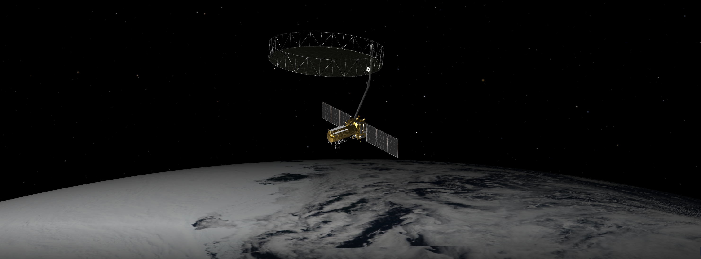
An equal collaboration between NASA and the Indian Space Research Organisation, NISAR will offer unprecedented insights into Earth’s constantly changing land and ice surfaces using synthetic aperture radar technology. The spacecraft, depicted here in an artist’s concept, will launch from India.
NASA/JPL-Caltech
A Q&A with the lead U.S. scientist of the mission, which will track changes in everything from wetlands to ice sheets to infrastructure damaged by natural disasters.
The upcoming U.S.-India NISAR (NASA-ISRO Synthetic Aperture Radar) mission will observe Earth like no mission before, offering insights about our planet’s ever-changing surface.
The NISAR mission is a first-of-a-kind dual-band radar satellite that will measure land deformation from earthquakes, landslides, and volcanoes, producing data for science and disaster response. It will track how much glaciers and ice sheets are advancing or retreating and it will monitor growth and loss of forests and wetlands for insights on the global carbon cycle.
As diverse as NISAR’s impact will be, the mission’s winding path to launch — in a few months’ time — has also been remarkable. Paul Rosen, NISAR’s project scientist at NASA’s Jet Propulsion Laboratory in Southern California, has been there at every step. He recently discussed the mission and what sets it apart.
NISAR Project Scientist Paul Rosen of NASA’s Jet Propulsion Laboratory first traveled to India in late 2011 to discuss collaboration with ISRO scientists on an Earth-observing radar mission. NASA and ISRO signed an agreement in 2014 to develop NISAR.
NASA/JPL-Caltech
How will NISAR improve our understanding of Earth?
The planet’s surfaces never stop changing — in some ways small and subtle, and in other ways monumental and sudden. With NISAR, we’ll measure that change roughly every week, with each pixel capturing an area about half the size of a tennis court. Taking imagery of nearly all Earth’s land and ice surfaces this frequently and at such a small scale — down to the centimeter — will help us put the pieces together into one coherent picture to create a story about the planet as a living system.
What sets NISAR apart from other Earth missions?
NISAR will be the first Earth-observing satellite with two kinds of radar — an L-band system with a 10-inch (25-centimeter) wavelength and an S-band system with a 4-inch (10-centimeter) wavelength.
Whether microwaves reflect or penetrate an object depends on their wavelength. Shorter wavelengths are more sensitive to smaller objects such as leaves and rough surfaces, whereas longer wavelengths are more reactive with larger structures like boulders and tree trunks.
So NISAR’s two radar signals will react differently to some features on Earth’s surface. By taking advantage of what each signal is or isn’t sensitive to, researchers can study a broader range of features than they could with either radar on its own, observing the same features with different wavelengths.
Is this new technology?
The concept of a spaceborne synthetic aperture radar, or SAR, studying Earth’s processes dates to the 1970s, when NASA launched Seasat. Though the mission lasted only a few months, it produced first-of-a-kind images that changed the remote-sensing landscape for decades to come.
Our data products will fit the needs of users across the mission’s science focus areas — ecosystems, cryosphere, and solid Earth — plus have many uses beyond basic research like soil-moisture and water resources monitoring.
We’ll make the data easily accessible. Given the volume of the data, NASA decided that it would be processed and stored in the cloud, where it’ll be free to access.
How did the ISRO partnership come about?
We proposed DESDynI (Deformation, Ecosystem Structure, and Dynamics of Ice), an L-band satellite, following the 2007 Decadal Survey by the National Academy of Sciences. At the time, ISRO was exploring launching an S-band satellite. The two science teams proposed a dual-band mission, and in 2014 NASA and ISRO agreed to partner on NISAR.
Since then, the agencies have been collaborating across more than 9,000 miles (14,500 kilometers) and 13 time zones. Hardware was built on different continents before being assembled in India to complete the satellite. It’s been a long journey — literally.
More About NISAR
The NISAR mission is an equal collaboration between NASA and ISRO and marks the first time the two agencies have cooperated on hardware development for an Earth-observing mission. Managed for the agency by Caltech, JPL leads the U.S. component of the project and is providing the mission’s L-band SAR. NASA is also providing the radar reflector antenna, the deployable boom, a high-rate communication subsystem for science data, GPS receivers, a solid-state recorder, and payload data subsystem.
Space Applications Centre Ahmedabad, ISRO’s lead center for payload development, is providing the mission’s S-band SAR instrument and is responsible for its calibration, data processing, and development of science algorithms to address the scientific goals of the mission. U R Rao Satellite Centre in Bengaluru, which leads the ISRO components of the mission, is providing the spacecraft bus. The launch vehicle is from ISRO’s Vikram Sarabhai Space Centre, launch services are through ISRO’s Satish Dhawan Space Centre, and satellite mission operations are by ISRO Telemetry Tracking and Command Network. National Remote Sensing Centre in Hyderabad is primarily responsible for S-band data reception, operational products generation, and dissemination.
This map depicts global temperature anomalies for meteorological summer in 2024 (June, July, and August). It shows how much warmer or cooler different regions of Earth were compared to the baseline average from 1951 to 1980. (Credit: NASA/NOAA)
Climate researchers from NASA and NOAA (National Oceanic and Atmospheric Administration) will release their annual assessments of global temperatures and discuss the major climate trends of 2024 during a media briefing at 12 p.m. EST Friday, Jan. 10.
Gavin Schmidt, director, NASA’s Goddard Institute for Space Studies
Russ Vose, chief, Monitoring and Assessment Branch, NOAA National Centers for Environmental Information
Media interested in participating must RSVP to NOAA by the time of the event.
NASA and NOAA are stewards of global temperature data and independently produce a record of Earth’s surface temperatures and changes based on historical observations over land and ocean.
For more information about NASA’s Earth science programs, visit: