Preparations for Next Moonwalk Simulations Underway (and Underwater)
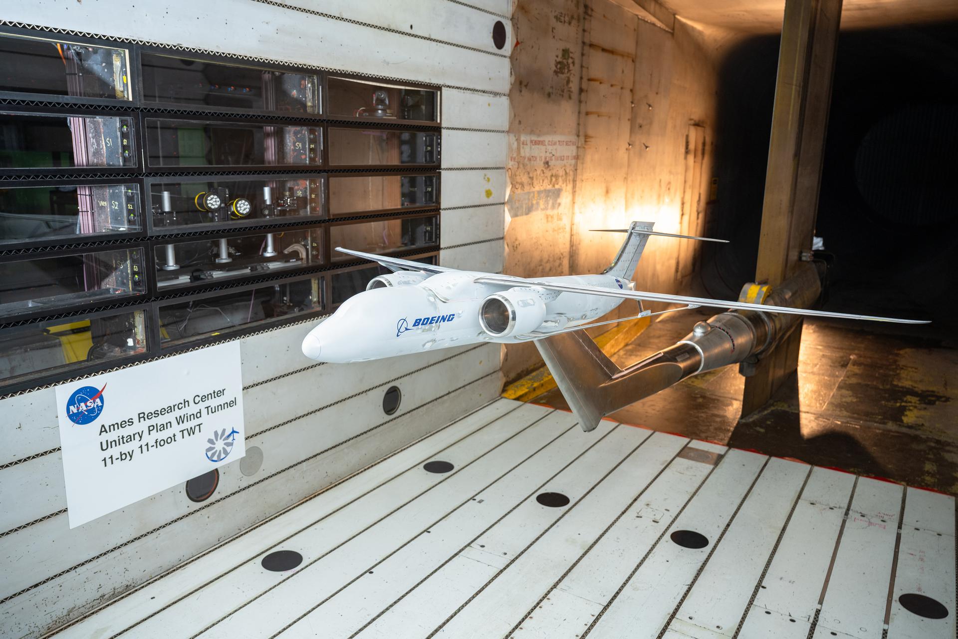
A Boeing-built X-66 full-span model underwent testing in the 11-Foot Transonic Unitary Plan Facility at NASA’s Ames Research Center in California’s Silicon Valley between January and March 2025.
NASA / Brandon Torres
NASA and Boeing are currently evaluating an updated approach to the agency’s Sustainable Flight Demonstrator project that would focus on demonstrating thin-wing technology with broad applications for multiple aircraft configurations.
Boeing’s proposed focus centers on a ground-based testbed to demonstrate the potential for long, thin-wing technology. Work on the X-66 flight demonstrator – which currently incorporates a more complex transonic truss braced wing concept that uses the same thin wing technology as well as aerodynamic, structural braces — would pause for later consideration based on the thin-wing testbed results and further truss-braced configuration studies.
Under this proposal, all aspects of the X-66 flight demonstrator’s design, as well as hardware acquired or modified for it, would be retained while the long, thin-wing technology is being investigated with more focus. NASA and Boeing would also continue to collaborate on research into the transonic truss-braced wing concept.
The proposal is based on knowledge gained through research conducted under the Sustainable Flight Demonstrator project so far.
Since NASA issued the Sustainable Flight Demonstrator award in 2023, the project has made significant progress toward its goal of informing future generations of more sustainable commercial airliners. Boeing and NASA have collaborated on wind tunnel tests, computational fluid dynamics modeling, and structural design and analysis aimed at exploring how best to approach fuel-efficient, sustainable designs.
This research has built confidence in the substantial potential energy-savings benefits that technologies investigated through the Sustainable Flight Demonstrator project and other NASA research can make possible. The Boeing proposal identifies the thin-wing concept as having broad applications for potential incorporation into aircraft with and without truss braces.
NASA and Boeing are discussing potential options for advancing these sustainable flight technologies. NASA’s ultimate goal for this sustainable aircraft research is to achieve substantial improvements for next-generation airliner efficiency, lower costs for travelers, reduced fuel costs and consumption, and increase U.S. aviation’s technological leadership.
Preparations for Next Moonwalk Simulations Underway (and Underwater)
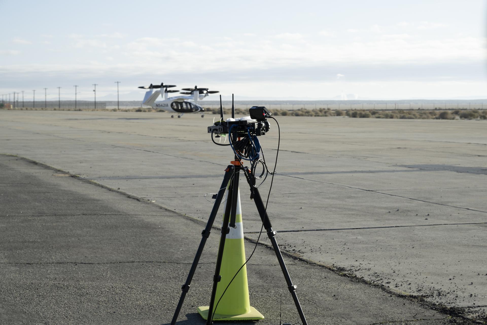
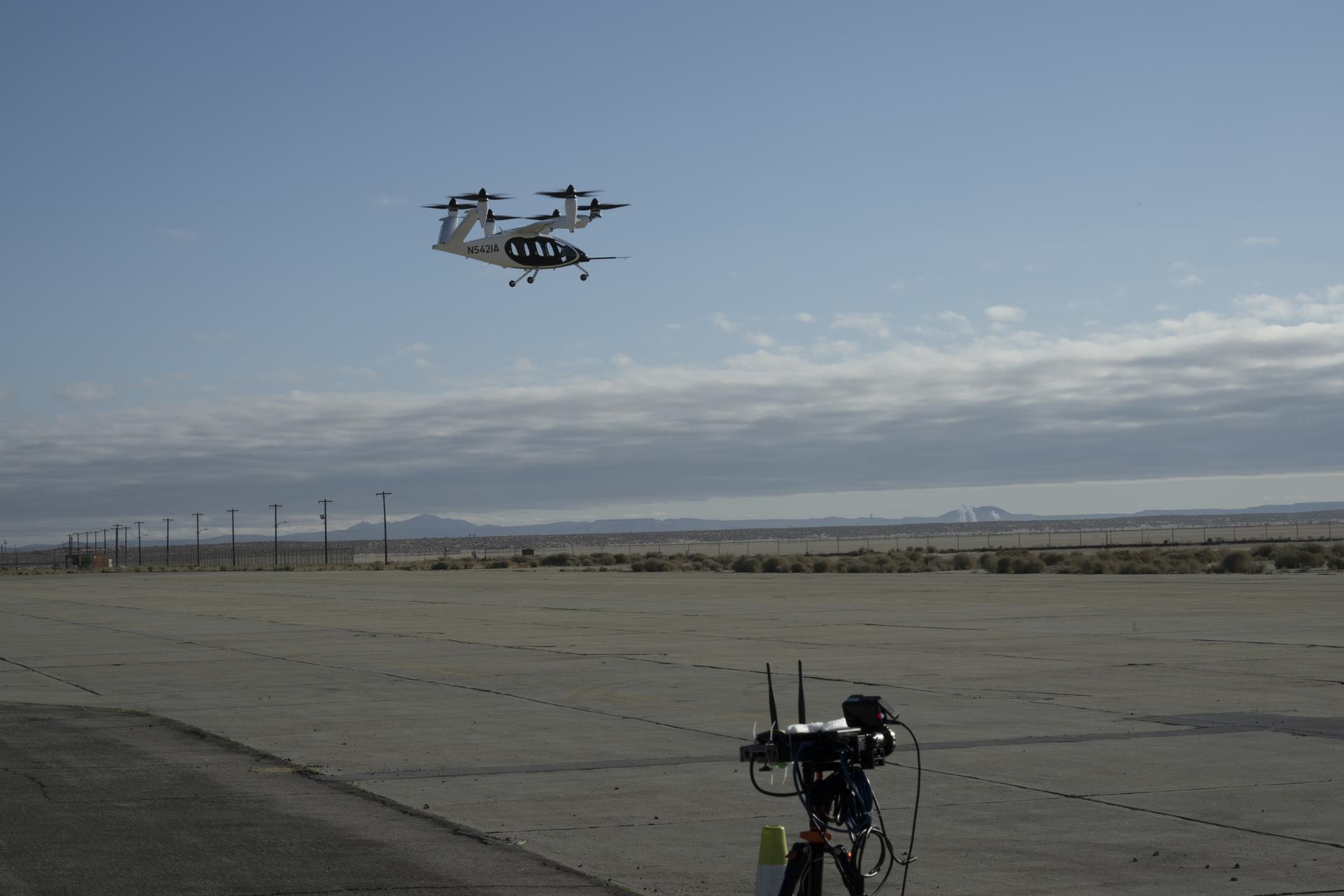
One of several NASA distributed sensing ground nodes is set up in the foreground while an experimental air taxi aircraft owned by Joby Aviation sits in the background near NASA’s Armstrong Flight Research Center in Edwards, California, on March 12, 2025. NASA is collecting information during this study to help advance future air taxi flights, especially those occurring in cities, to track aircraft moving through traffic corridors and around landing zones.
NASA/Genaro Vavuris
NASA engineers began using a network of ground sensors in March to collect data from an experimental air taxi to evaluate how to safely integrate such vehicles into airspace above cities – in all kinds of weather.
Researchers will use the campaign to help improve tools to assist with collision avoidance and landing operations and ensure safe and efficient air taxi operations in various weather conditions.
For years, NASA has looked at how wind shaped by terrain, including buildings in urban areas, can affect new types of aircraft. The latest test, which is gathering data from a Joby Aviation demonstrator aircraft, looks at another kind of wind – that which is generated by the aircraft themselves.
Joby flew its air taxi demonstrator over NASA’s ground sensor array near the agency’s Armstrong Flight Research Center in Edwards, California producing air flow data. The Joby aircraft has six rotors that allow for vertical takeoffs and landings, and tilt to provide lift in flight. Researchers focused on the air pushed by the propellers, which rolls into turbulent, circular patterns of wind.
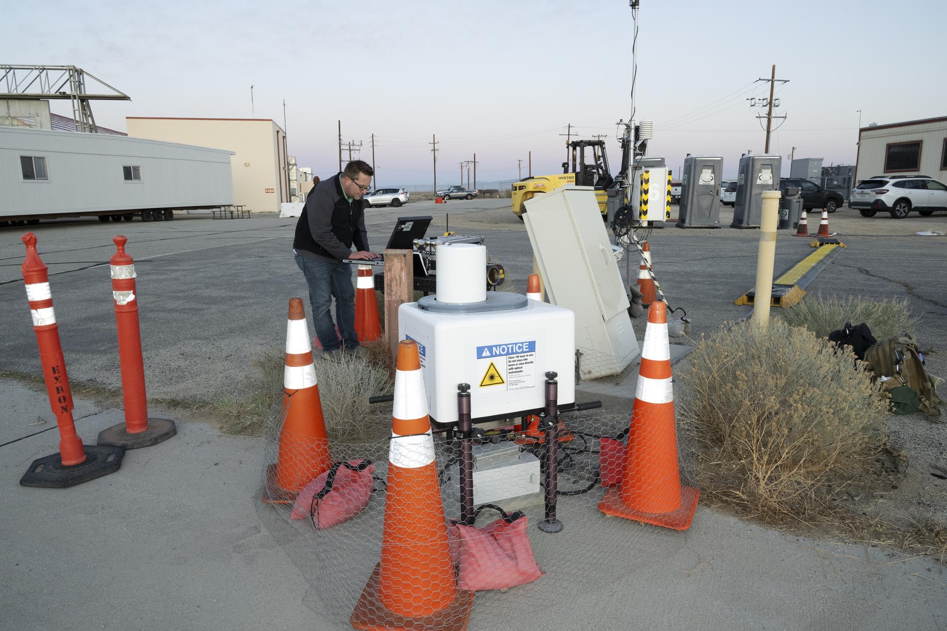
NASA aeronautical meteorologist Luke Bard adjusts one of several wind lidar (light detection and ranging) sensors near NASA’s Armstrong Flight Research Center in Edwards, California, on March 12, 2025, in preparation to collect data from Joby Aviation’s experimental air taxi aircraft. NASA is collecting information during this study to help advance weather-tolerant air taxi operations for the entire industry
NASA/Genaro Vavuris
This rolling wind can affect the aircraft’s performance, especially when it’s close to the ground, as well as others flying in the vicinity and people on the ground. Such wind turbulence is difficult to measure, so NASA enhanced its sensors with a new type of lidar – a system that uses lasers to measure precise distances – and that can map out the shapes of wind features.
“The design of this new type of aircraft, paired with the NASA lidar technology during this study, warrants a better understanding of possible wind and turbulence effects that can influence safe and efficient flights,” said Grady Koch, lead for this research effort, from NASA’s Langley Research Center in Hampton, Virginia.
Data to Improve Aircraft Tracking
NASA also set up a second array of ground nodes including radar, cameras, and microphones in the same location as the sensors to provide additional data on the aircraft. These nodes will collect tracking data during routine flights for several months.
The agency will use the data gathered from these ground nodes to demonstrate the tracking capabilities and functions of its “distributed sensing” technology, which involves embedding multiple sensors in an area where aircraft are operating.
One of multiple NASA distributed sensing ground nodes is set up in the foreground while an experimental air taxi aircraft owned by Joby Aviation hovers in the background near NASA’s Armstrong Flight Research Center in Edwards, California, on March 12, 2025. NASA is collecting information during this study to help advance future air taxi flights, especially those occurring in cities, to track aircraft moving through traffic corridors and around landing zones.
NASA/Genaro Vavuris
This technology will be important for future air taxi flights, especially those occurring in cities by tracking aircraft moving through traffic corridors and around landing zones. Distributed sensing has the potential to enhance collision avoidance systems, air traffic management, ground-based landing sensors, and more.
“Our early work on a distributed network of sensors, and through this study, gives us the opportunity to test new technologies that can someday assist in airspace monitoring and collision avoidance above cities,” said George Gorospe, lead for this effort from NASA’s Ames Research Center in California’s Silicon Valley.
Using this data from an experimental air taxi aircraft, NASA will further develop the technology needed to help create safer air taxi flights in high-traffic areas. Both of these efforts will benefit the companies working to bring air taxis and drones safely into the airspace.
Preparations for Next Moonwalk Simulations Underway (and Underwater)
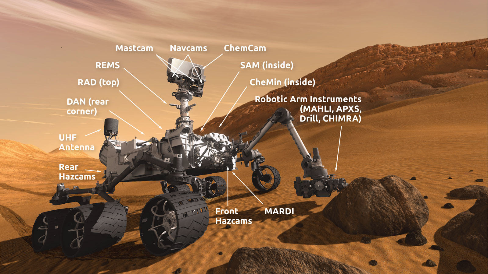
NASA’s Curiosity Mars rover sees its tracks receding into the distance at a site nicknamed “Ubajara” on April 30, 2023. This site is where Curiosity made the discovery of siderite, a mineral that may help explain the fate of the planet’s thicker ancient atmosphere.
Credit: NASA/JPL-Caltech/MSSS
New findings from NASA’s Curiosity Mars rover could provide an answer to the mystery of what happened to the planet’s ancient atmosphere and how Mars has evolved over time.
Researchers have long believed that Mars once had a thick, carbon dioxide-rich atmosphere and liquid water on the planet’s surface. That carbon dioxide and water should have reacted with Martian rocks to create carbonate minerals. Until now, though, rover missions and near-infrared spectroscopy analysis from Mars-orbiting satellites haven’t found the amounts of carbonate on the planet’s surface predicted by this theory.
Reported in an April paper in Science, data from three of Curiosity’s drill sites revealed the presence of siderite, an iron carbonate mineral, within the sulfate-rich rocky layers of Mount Sharp in Mars’ Gale Crater.
“The discovery of abundant siderite in Gale Crater represents both a surprising and important breakthrough in our understanding of the geologic and atmospheric evolution of Mars,” said Benjamin Tutolo, associate professor at the University of Calgary, Canada, and lead author of the paper.
To study the Red Planet’s chemical and mineral makeup, Curiosity drills three to four centimeters down into the subsurface, then drops the powdered rock samples into its CheMin instrument. The instrument, led by NASA’s Ames Research Center in California’s Silicon Valley, uses X-ray diffraction to analyze rocks and soil. CheMin’s data was processed and analyzed by scientists at the Astromaterials Research and Exploration Science (ARES) Division at NASA’s Johnson Space Center in Houston.
“Drilling through the layered Martian surface is like going through a history book,” said Thomas Bristow, research scientist at NASA Ames and coauthor of the paper. “Just a few centimeters down gives us a good idea of the minerals that formed at or close to the surface around 3.5 billion years ago.”
The discovery of this carbonate mineral in rocks beneath the surface suggests that carbonate may be masked by other minerals in near-infrared satellite analysis. If other sulfate-rich layers across Mars also contain carbonates, the amount of stored carbon dioxide would be a fraction of that needed in the ancient atmosphere to create conditions warm enough to support liquid water. The rest could be hidden in other deposits or have been lost to space over time.
In the future, missions or analyses of other sulfate-rich areas on Mars could confirm these findings and help us better understand the planet’s early history and how it transformed as its atmosphere was lost.
Curiosity, part of NASA’s Mars Exploration Program (MEP) portfolio, was built by NASA’s Jet Propulsion Laboratory, which is managed by Caltech in Pasadena, California. JPL leads the mission on behalf of NASA’s Science Mission Directorate in Washington.
Preparations for Next Moonwalk Simulations Underway (and Underwater)
Editor’s Note: This article was updated April 16, 2025, to reflect the March 26 start date of NASA’s Alta X flights and provide additional details about the data collected.
Drones were a key part of testing new technology in support of a prescribed burn in Geneva State Forest, which is about 100 miles south of Montgomery, Alabama. The effort is part of the agency’s multi-year FireSense project, which is aimed at testing technologies that could eventually serve the U.S. Forest Service as well as local, state, and other federal wildland fire agencies. From left are Tim Wallace and Michael Filicchia of the Desert Research Institute in Nevada; Derek Abramson, Justin Hall, and Alexander Jaffe of NASA’s Armstrong Flight Research Center in Edwards California; and Alana Dachtler of International Met Systems of Kentwood, Michigan.
NASA/Jackie Shuman
Advancements in NASA’s airborne technology have made it possible to gather localized wind data and assess its impacts on smoke and fire behavior. This information could improve wildland fire decision making and enable operational agencies to better allocate firefighters and resources. A small team from NASA’s Armstrong Flight Research Center in Edwards, California, is demonstrating how some of these technologies work.
Two instruments from NASA’s Langley Research Center in Hampton, Virginia – a sensor gathering 3D wind data and a radiosonde that measures temperature, barometric pressure, and relative humidity data – were installed on NASA Armstrong’s Alta X drone for a prescribed burn in Geneva State Forest, which is about 100 miles south of Montgomery, Alabama. The effort is part of the agency’s multi-year FireSense project, which is aimed at testing technologies that could eventually serve the U.S. Forest Service as well as local, state, and other federal wildland fire agencies.
“The objectives for the Alta X portion of the multi-agency prescribed burn include a technical demonstration for wildland fire practitioners, and data collection at various altitudes for the Alabama Forestry Commission operations,” said Jennifer Fowler, FireSense project manager. “Information gathered at the different altitudes is essential to monitor the variables for a prescribed burn.”
Those variables include the mixing height, which is the extent or depth to which smoke will be dispersed, a metric Fowler said is difficult to predict. Relative humidity must also be above 30% for a prescribed burn to meet requirements in Geneva State Forest. The technology to collect these measurements locally is not readily available in wildland fire operations, making the Alta X and its instruments key in the demonstration of prescribed burn technology.
A drone from NASA’s Armstrong Flight Research Center, Edwards, California, flies with a sensor to gather 3D wind data and a radiosonde that measures temperature, barometric pressure, and humidity data from NASA’s Langley Research Center in Hampton, Virginia. The drone and instruments supported a prescribed burn in Geneva State Forest, which is about 100 miles south of Montgomery, Alabama. The effort is part of the agency’s multi-year FireSense project, which is aimed at testing technologies that could eventually serve the U.S. Forest Service as well as local, state, and other federal wildland fire agencies.
International Met Systems/Alana Dachtler
In addition to the Alta X flights beginning March 26, NASA Armstrong’s B200 King Air will fly over actively burning fires at an altitude of about 6,500 feet. Sensors onboard other aircraft supporting the mission will fly at lower and higher altitudes before, during, and after the fire for required data collection. The multi-agency mission will provide data to improve models to better predict fire behavior and effects, including smoke lofting, trajectory, and dispersion.
Small, uncrewed aircraft system pilots from NASA Armstrong completed final preparations to travel to Alabama and set up for the research flights. The team – including Derek Abramson, chief engineer for the subscale flight research laboratory; Justin Hall, NASA Armstrong chief pilot of small, uncrewed aircraft systems; and Alexander Jaffe, a drone pilot – will set up, fly, observe airborne operations, all while keeping additional aircraft batteries charged. The launch and recovery of the Alta X is manual, the mission profile is flown autonomously to guarantee the same conditions for data collection.
“The flight profile is vertical – straight up and straight back down from the surface to about 3,000 feet altitude,” Abramson said. “We will characterize the mixing height and changes in moisture, mapping out how they both change throughout the day in connection with the burn.”
In August 2024, a team of NASA researchers used the NASA Langley Alta X and weather instruments in Missoula, Montana, for a FireSense project drone technology demonstration. These instruments were used to generate localized forecasting that provides precise and sustainable meteorological data to predict fire behavior and smoke impacts.
Justin Link, left, pilot for small uncrewed aircraft systems, and Justin Hall, chief pilot for small uncrewed aircraft systems, install weather instruments on an Alta X drone at NASAs Armstrong Flight Research Center in Edwards, California. Members of the center’s Dale Reed Subscale Flight Research Laboratory used the Alta X to support the agency’s FireSense project in March 2025 for a prescribed burn in Geneva State Forest, which is about 100 miles south of Montgomery, Alabama.
Preparations for Next Moonwalk Simulations Underway (and Underwater)
A Massachusetts Institute of Technology Lincoln Laboratory pilot controls a drone during NASA’s In-Time Aviation Safety Management System test series in collaboration with a George Washington University team July 17-18, 2024, at the U.S. Army’s Fort Devens in Devens, Massachusetts.
MIT Lincoln Laboratory/Jay Couturier
From agriculture and law enforcement to entertainment and disaster response, industries are increasingly turning to drones for help, but the growing volume of these aircraft will require trusted safety management systems to maintain safe operations.
NASA is testing a new software system to create an improved warning system – one that can predict hazards to drones before they occur. The In-Time Aviation Safety Management System (IASMS) will monitor, assess, and mitigate airborne risks in real time. But making sure that it can do all that requires extensive experimentation to see how its elements work together, including simulations and drone flight tests.
“If everything is going as planned with your flight, you won’t notice your in-time aviation safety management system working,” said Michael Vincent, NASA acting deputy project manager with the System-Wide Safety project at NASA’s Langley Research Center in Hampton, Virginia. “It’s before you encounter an unusual situation, like loss of navigation or communications, that the IASMS provides an alert to the drone operator.”
The team completed a simulation in the Human-Autonomy Teaming Laboratory at NASA’s Ames Research Center in California’s Silicon Valley on March 5 aimed at finding out how critical elements of the IASMS could be used in operational hurricane relief and recovery.
During this simulation, 12 drone pilots completed three 30-minute sessions where they managed up to six drones flying beyond visual line of sight to perform supply drops to residents stranded after a severe hurricane. Additional drones flew scripted search and rescue operations and levee inspections in the background. Researchers collected data on pilot performance, mission success, workload, and perceptions of the experiences, as well as the system’s usability.
This simulation is part of a longer-term strategy by NASA to advance this technology. The lessons learned from this study will help prepare for the project’s hurricane relief and recovery flight tests, planned for 2027.
As an example of this work, in the summer of 2024 NASA tested its IASMS during a series of drone flights in collaboration with the Ohio Department of Transportation in Columbus, Ohio, and in a separate effort, with three university-led teams.
For the Ohio Department of Transportation tests, a drone flew with the NASA-developed IASMS software aboard, which communicated back to computers at NASA Langley. Those transmissions gave NASA researchers input on the system’s performance.
Students from the Ohio State University participate in drone flights during NASA’s In-Time Aviation Safety Management System test series in collaboration with the Ohio Department of Transportation from March to July 2024 at the Columbus Aero Club in Ohio.
NASA/Russell Gilabert
NASA also conducted studies with The George Washington University (GWU), the University of Notre Dame, and Virginia Commonwealth University (VCU). These occurred at the U.S. Army’s Fort Devens in Devens, Massachusetts with GWU; near South Bend, Indiana with Notre Dame; and in Richmond, Virginia with VCU. Each test included a variety of types of drones, flight scenarios, and operators.
Students from Virginia Commonwealth University walk toward a drone after a flight as part of NASA’s In-Time Aviation Safety Management System (IASMS) test series July 16, 2024, in Richmond, Virginia.
NASA/Dave Bowman
Each drone testing series involved a different mission for the drone to perform and different hazards for the system to avoid. Scenarios included, for example, how the drone would fly during a wildfire or how it would deliver a package in a city. A different version of the NASA IASMS was used to fit the scenario depending on the mission, or depending on the flight area.
Students from the University of Notre Dame prepare a small drone for takeoff as part of NASA’s In-Time Aviation Safety Management System (IASMS) university test series, which occurred on August 21, 2024 in Notre Dame, Indiana.
University of Notre Dame/Wes Evard
When used in conjunction with other systems such as NASA’s Unmanned Aircraft System Traffic Management, IASMS may allow for routine drone flights in the U.S. to become a reality. The IASMS adds an additional layer of safety for drones, assuring the reliability and trust if the drone is flying over a town on a routine basis that it remains on course while avoiding hazards along the way.
“There are multiple entities who contribute to safety assurance when flying a drone,” Vincent said. “There is the person who’s flying the drone, the company who designs and manufactures the drone, the company operating the drone, and the Federal Aviation Administration, who has oversight over the entire National Airspace System. Being able to monitor, assess and mitigate risks in real time would make the risks in these situations much more secure.”
Preparations for Next Moonwalk Simulations Underway (and Underwater)
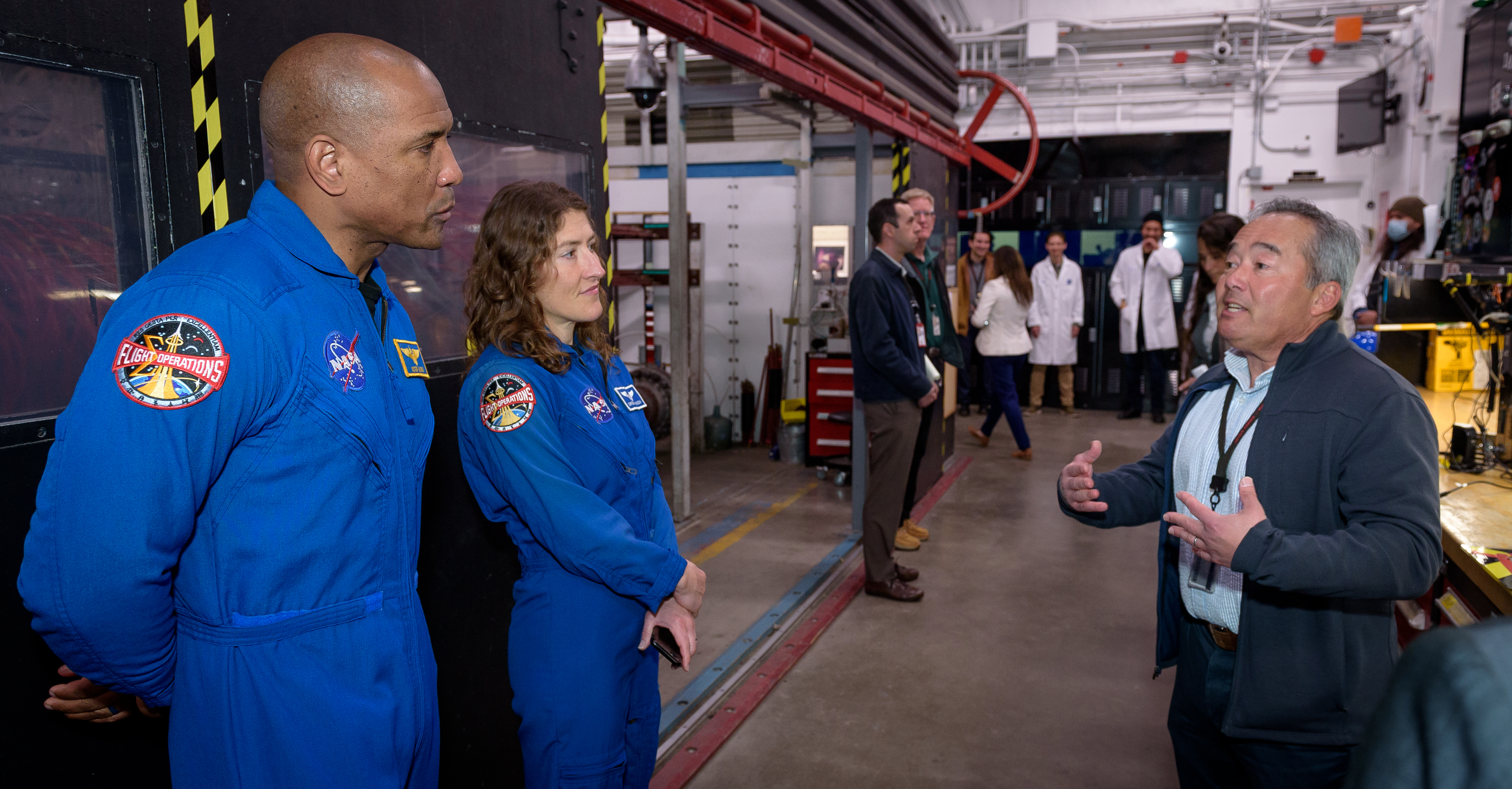
Astronauts Victor Glover and Christina Koch tour the Arc Jet Facility at NASA’s Ames Research Center, learning more about the testing equipment’s capabilities to analyze thermal protection systems from George Raiche, thermophysics facilities branch chief at Ames.
NASA/Donald Richey
As NASA prepares to send astronauts to the Moon aboard the Orion spacecraft, research, testing, and development at NASA’s Ames Research Center in California’s Silicon Valley has played a critical role.
Recently, Ames welcomed Artemis II astronauts Christina Koch and Victor Glover and Orion leaders Debbie Korth, deputy program manager, and Luis Saucedo, deputy crew and service module manager, to tour Ames facilities that support the Orion Program and celebrate the achievements of employees.
The group started their visit at the Arc Jet Complex, where researchers use extremely hot, high-speed gases to simulate the intense heat of atmospheric reentry before visiting the Sensors & Thermal Protection Systems Advanced Research Laboratories. The team works to develop sensors and flight instrumentation that measure heat shield response throughout a mission.
These systems were used to develop and test Orion’s thermal protection system to ensure the safety of astronauts during future missions. After the successful return of the Artemis I Orion spacecraft, Ames research was essential when analyzing unexpected charring loss on the heat shield.
Debbie Korth, Orion deputy program manager, presents awards to the Ames workforce at the Orion Circle of Excellence Awards Ceremony, while astronauts Christina Koch and Victor Glover look on.
NASA/Donald Richey
The visit culminated in an award ceremony to honor employees with outstanding performance and a legacy of service to the Orion Program. Thirty-two employees were honored for their individual or team contributions.
“The Ames workforce has played an important role in developing, testing, and validating the Orion spacecraft’s thermal protection system as well as supporting its software and guidance, navigation, and control,” said Eugene Tu, NASA Ames center director. “I’m pleased to see their contributions recognized and celebrated by program leadership and two of the astronauts whose safety and success were in mind when ensuring these systems are safe, reliable, and the highest quality possible.”
Preparations for Next Moonwalk Simulations Underway (and Underwater)
The Starling swarm’s extended mission tested advanced autonomous maneuvering capabilities.
NASA/Daniel Rutter
As missions to low Earth orbit become more frequent, space traffic coordination remains a key element to efficiently operating in space. Different satellite operators using autonomous systems need to operate together and manage increasing workloads. NASA’s Starling spacecraft swarm recently tested a coordination with SpaceX’s Starlink constellation, demonstrating a potential solution to enhance space traffic coordination.
Led by the Small Spacecraft Technology program at NASA’s Ames Research Center in California’s Silicon Valley, Starling originally set out to demonstrate autonomous planning and execution of orbital maneuvers with the mission’s four small spacecraft. After achieving its primary objectives, the Starling mission expanded to become Starling 1.5, an experiment to demonstrate maneuvers between the Starling swarm and SpaceX’s Starlink satellites, which also maneuver autonomously.
Coordination in Low Earth Orbit
Current space traffic coordination systems screen trajectories of spacecraft and objects in space and alert operators on the ground of potential conjunctions, which occur when two objects exceed an operator’s tolerance for a close approach along their orbital paths. Spacecraft operators can request notification at a range of probabilities, often anywhere from a 1 in 10,000 likelihood of a collision to 1 in 1,000,000 or lower.
Conjunction mitigation between satellite operators requires manual coordination through calls or emails on the ground. An operator may receive a notification for a number of reasons including recently maneuvering their satellite, nearby space debris, or if another satellite adjusts its orbit.
Once an operator is aware of a potential conjunction, they must work together with other operators to reduce the probability of a collision. This can result in time-consuming calls or emails between ground operations teams with different approaches to safe operations. It also means maneuvers may require several days to plan and implement. This timeline can be challenging for missions that require quick adjustments to capture important data.
“Occasionally, we’ll do a maneuver that we find out wasn’t necessary if we could have waited before making a decision. Sometimes you can’t wait three days to reposition and observe. Being able to react within a few hours can make new satellite observations possible,” said Nathan Benz, project manager of Starling 1.5 at NASA Ames.
Improving Coordination for Autonomous Maneuvering
The first step in improving coordination was to develop a reliable way to signal maneuver responsibility between operators. “Usually, SpaceX takes the responsibility to move out of the way when another operator shares their predicted trajectory information,” said Benz.
SpaceX and NASA collaborated to design a conjunction screening service, which SpaceX then implemented. Satellite operators can submit trajectories and receive conjunction data quickly, then accept responsibility to maneuver away from a potential conjunction.
“For this experiment, NASA’s Starling accepted responsibility to move using the screening service, successfully tested our system’s performance, then autonomously planned and executed the maneuver for the NASA Starling satellite, resolving a close approach with a Starlink satellite,” said Benz.
Through NASA’s Starling 1.5 experiment, the agency helped validate SpaceX’s Starlink screening service. The Office of Space Commerce within the U.S. Department of Commerce also worked with SpaceX to understand and assess the Starlink screening service.
Quicker Response to Changes on Earth
The time it takes to plan maneuvers in today’s orbital traffic environment limits the number of satellites a human operator can manage and their ability to collect data or serve customers.
“A fully automated system that is flexible and adaptable between satellite constellations is ideal for an environment of multiple satellite operators, all of whom have differing criteria for mitigating collision risks,” said Lauri Newman, program officer for NASA’s Conjunction Assessment Risk Analysis program at the agency’s headquarters in Washington.
Reducing the time necessary to plan maneuvers could open up a new class of missions, where quick responses to changes in space or on Earth’s surface are possible. Satellites capable of making quicker movements could adjust their orbital position to capture a natural disaster from above, or respond to one swarm member’s interesting observations, moving to provide a more thorough look.
“With improved access and use of low Earth orbit and the necessity to provide a more advanced space traffic coordination system, Starling 1.5 is providing critical data. Starling 1.5 is the result of a successful partnership between NASA, the Department of Commerce, and SpaceX, maturing technology to solve such challenges,” said Roger Hunter, program manager of the Small Spacecraft Technology program. “We look forward to the sustained impact of the Starling technologies as they continue demonstrating advancements in spacecraft coordination, cooperation, and autonomy.”
NASA Ames leads the Starling projects. NASA’s Small Spacecraft Technology program within the Space Technology Mission Directorate funds and manages the Starling mission.
Preparations for Next Moonwalk Simulations Underway (and Underwater)
Advanced Capabilities for Emergency Response Operations (ACERO) researchers Lynne Martin, left, and Connie Brasil use the Portable Airspace Management System (PAMS) to view a simulated fire zone and set a drone flight plan during a flight test the week of March 17, 2025.
NASA/Brandon Torres-Navarrete
Editor’s Note: This article was updated March 27, 2025, to reflect the final dates for the testing period.
NASA researchers conducted initial validation of a new airspace management system designed to enable crews to use aircraft to fight and monitor wildland fires 24 hours a day, even during low-visibility conditions.
From March 17-26, NASA’s Advanced Capabilities for Emergency Response Operations (ACERO) project stationed researchers at multiple strategic locations across the foothills of the Sierra de Salinas mountains in Monterey County, California. Their mission: to test and validate a new, portable system that can provide reliable airspace management under poor visual conditions, one of the biggest barriers for aerial wildland firefighting support.
The mission was a success.
“At NASA, we have decades of experience leveraging our aviation expertise in ways that improve everyday life for Americans,” said Carol Carroll, deputy associate administrator for NASA’s Aeronautics Research Mission Directorate at agency headquarters in Washington. “We need every advantage possible when it comes to saving lives and property when wildfires affect our communities, and ACERO technology will give responders critical new tools to monitor and fight fires.”
NASA ACERO researchers Samuel Zuniga,left, and Jonathan La Plain prepare for a drone flight test using the PAMS in Salinas on March 19, 2025.
NASA/Brandon Torres-Navarrete
One of the barriers for continued monitoring, suppression, and logistics support in wildland fire situations is a lack of tools for managing airspace and air traffic that can support operations under all visibility conditions. Current aerial firefighting operations are limited to times with clear visibility when a Tactical Air Group Supervisor or “air boss” in a piloted aircraft can provide direction. Otherwise, pilots may risk collisions.
The ACERO technology will provide that air boss capability for remotely piloted aircraft operations – and users will be able to do it from the ground. The project’s Portable Airspace Management System (PAMS) is a suitcase-sized solution that builds on decades of NASA air traffic and airspace management research. The PAMS units will allow pilots to view the locations and operational intents of other aircraft, even in thick smoke or at night.
During the testing in Salinas, researchers evaluated the PAMS’ core airspace management functions, including strategic coordination and the ability to automatically alert pilots once their aircrafts exit their preapproved paths or the simulated preapproved fire operation zone.
Using the PAMS prototype, researchers were able to safely conduct flight operations of a vertical takeoff and landing aircraft operated by Overwatch Aero, LLC, of Solvang, California, and two small NASA drones.
Flying as if responding to a wildfire scenario, the Overwatch aircraft connected with two PAMS units in different locations. Though the systems were separated by mountains and valleys with weak cellular service, the PAMS units were able to successfully share and display a simulated fire zone, aircraft location, flight plans, and flight intent, thanks to a radio communications relay established by the Overwatch aircraft.
Operating in a rural mountain range validated that PAMS could work successfully in an actual wildland fire environment.
“Testing in real mountainous environments presents numerous challenges, but it offers significantly more value than lab-based testing,” said Dr. Min Xue, ACERO project manager at NASA’s Ames Research Center in California’s Silicon Valley. “The tests were successful, providing valuable insights and highlighting areas for future improvement.”
NASA ACERO researchers fly a drone to test the PAMS during a flight test on March 19, 2025.
NASA/Brandon Torres-Navarrete
Pilots on the ground used PAMS to coordinate the drones, which performed flights simulating aerial ignition – the practice of setting controlled, intentional fires to manage vegetation, helping to control fires and reduce wildland fire risk.
As a part of the testing, Joby Aviation of Santa Cruz, California, flew its remotely piloted aircraft, similar in size to a Cessna Grand Caravan, over the testing site. The PAMS system successfully exchanged aircraft location and flight intent with Joby’s mission management system. The test marked the first successful interaction between PAMS and an optionally piloted aircraft.
Fire chiefs from the California Department of Forestry and Fire Protection (CAL FIRE) attended the testing and provided feedback on the system’s functionality, features that could improve wildland fire air traffic coordination, and potential for integration into operations.
“We appreciate the work being done by the NASA ACERO program in relation to portable airspace management capabilities,” said Marcus Hernandez, deputy chief for CAL FIRE’s Office of Wildfire Technology. “It’s great to see federal, state, and local agencies, as it is important to address safety and regulatory challenges alongside technological advancements.”
ACERO chief engineer Joey Mercer, right, shows the Portable Airspace Management System (PAMS) to Cal Fire representatives Scott Eckman, center, and Pete York, left, in preparation for the launch of the Overwatch Aero FVR90 Vertical Take Off and Landing (VTOL) test “fire” information sharing, airspace management, communication relay, and aircraft deconfliction capabilities during the Advanced Capabilities for Emergency Response Operations (ACERO) test in Salinas, California.
NASA/Brandon Torres-Navarrete
These latest flights build on successful PAMS testing in Watsonville, California, in November 2024. ACERO will use flight test data and feedback from wildland fire agencies to continue building out PAMS capabilities and will showcase more robust information-sharing capabilities in the coming years.
NASA’s goal for ACERO is to validate this technology, so it can be developed for wildland fire crews to use in the field, saving lives and property. The project is managed by NASA’s Airspace Operations and Safety Program and supports the agency’s Advanced Air Mobility mission.
ACERO’s PAMS unit shown during a flight test on March 19, 2025
NASA’s Advanced Capabilities for Emergency Response Operations (ACERO) project is testing its portable airspace management system this March in the foothills...
Preparations for Next Moonwalk Simulations Underway (and Underwater)
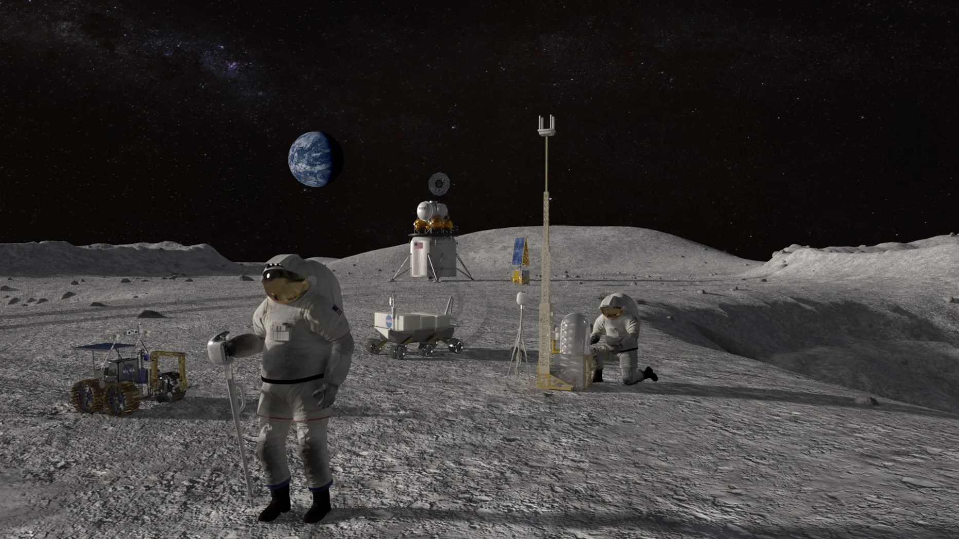
This artist’s concept shows astronauts working on the Moon alongside different technology systems. The Data & Reasoning Fabric technology could help these systems operate in harmony, supporting the astronauts and ground control on Earth.
Credit: NASA
Imagine your car is in conversation with other traffic and road signals as you travel. Those conversations help your car anticipate actions you can’t see: the sudden slowing of a truck as it begins to turn ahead of you, or an obscured traffic signal turning red. Meanwhile, this system has plotted a course that will drive you toward a station to recharge or refuel, while a conversation with a weather service prepares your windshield wipers and brakes for the rain ahead.
This trip requires a lot of communication among systems from companies, government agencies, and organizations. How might these different entities – each with their own proprietary technology – share data safely in real time to make your trip safe, efficient, and enjoyable?
Technologists at NASA’s Ames Research Center in California’s Silicon Valley created a framework called Data & Reasoning Fabric (DRF), a set of software infrastructure, tools, protocols, governance, and policies that allow safe, secure data sharing and logical prediction-making across different operators and machines. Originally developed with a focus on providing autonomous aviation drones with decision-making capabilities, DRF is now being explored for other applications.
This means that one day, DRF-informed technology could allow your car to receive traffic data safely and securely from nearby stoplights and share data with other vehicles on the road. In this scenario, DRF is the choreographer of a complex dance of moving objects, ensuring each moves seamlessly in relation to one another towards a shared goal. The system is designed to create an integrated environment, combining data from systems that would otherwise be unable to interact with each other.
“DRF is built to be used behind the scenes,” said David Alfano, chief of the Intelligent Systems Division at Ames. “Companies are developing autonomous technology, but their systems aren’t designed to work with technology from competitors. The DRF technology bridges that gap, organizing these systems to work together in harmony.”
Traffic enhancements are just one use case for this innovative system. The technology could enhance how we use autonomy to support human needs on Earth, in the air, and even on the Moon.
Supporting Complex Logistics
To illustrate the technology’s impact, the DRF team worked with the city of Phoenix on an aviation solution to improve transportation of critical medical supplies from urban areas out to rural communities with limited access to these resources. An autonomous system identified where supplies were needed and directed a drone to pick up and transport supplies quickly and safely.
“All the pieces need to come together, which takes a lot of effort. The DRF technology provides a framework where suppliers, medical centers, and drone operators can work together efficiently,” said Moustafa Abdelbaky, senior computer scientist at Ames. “The goal isn’t to remove human involvement, but help humans achieve more.”
The DRF technology is part of a larger effort at Ames to develop concepts that enable autonomous operations while integrating them into the public and commercial sector to create safer, efficient environments.
“At NASA, we’re always learning something. There’s a silver lining when one project ends, you can identify a new lesson learned, a new application, or a new economic opportunity to continue and scale that work,” said Supreet Kaur, lead systems engineer at Ames. “And because we leverage all of the knowledge we’ve gained through these experiments, we are able to make future research more robust.”
Choreographed Autonomy
Industries like modern mining involve a variety of autonomous and advanced vehicles and machinery, but these systems face the challenge of communicating sufficiently to operate in the same area. The DRF technology’s “choreography” might help them work together, improving efficiency. Researchers met with a commercial mining company to learn what issues they struggle with when using autonomous equipment to identify where DRF might provide future solutions.
“If an autonomous drill is developed by one company, but the haul trucks are developed by another, those two machines are dancing to two different sets of music. Right now, they need to be kept apart manually for safety,” said Johnathan Stock, chief scientist for innovation at the Ames Intelligent Systems Division. “The DRF technology can harmonize their autonomous work so these mining companies can use autonomy across the board to create a safer, more effective enterprise.”
Further testing of DRF on equipment like those used in mines could be done at the NASA Ames Roverscape, a surface that includes obstacles such as slopes and rocks, where DRF’s choreography could be put to the test.
Stock also envisions DRF improving operations on the Moon. Autonomous vehicles could transport materials, drill, and excavate, while launch vehicles come and go. These operations will likely include systems from different companies or industries and could be choreographed by DRF.
As autonomous systems and technologies increase across markets, on Earth, in orbit, and on the Moon, DRF researchers are ready to step on the dance floor to make sure everything runs smoothly.
“When everyone’s dancing to the same tune, things run seamlessly, and more is possible.”
A group of attendees of the joint NASA-USGS workshop, Planetary Subsurface Exploration for Science and Resources, gathers for a photo at NASA’s Ames Research Center on Feb. 11, 2025. Workshop participants discussed observations, technologies, and operations needed to support new economies for terrestrial and off-world resources, including critical minerals.
NASA/Brandon Torres Navarrete
NASA and the U.S. Geological Survey (USGS) welcomed a community of government, industry, and international partners to explore current technology needs around natural resources – both on Earth and “off world.” During a workshop held in February at NASA’s Ames Research Center in California’s Silicon Valley, participants discussed technologies that will improve the ability to detect, assess, and develop resources, such as critical minerals and water ice to be found on our Moon, other planets and their moons, and asteroids.
More than 300 attendees, taking part in person and virtually, worked to define the elements needed to find and map resources beyond Earth to support the growing space economy. These include sensors to image the subsurface of planetary bodies, new platforms for cost-effective operations, and technologies that enable new concepts of operation for these systems.
Scientific studies and measurements of off-world sites will be key to detecting and characterizing resources of interest, creating an important synergy with technology goals and helping to answer fundamental science questions as well.
The workshop was the third in a series called Planetary Subsurface Exploration for Science and Resources. By leveraging the expertise gained from decades of resource exploration on this planet and that of the space technology and space mission communities, NASA and USGS aim to spark collaboration across industry, government, and academia to develop new concepts and technologies.
Participants in the NASA-USGS off-world resources workshop take part in a panel review of technology opportunities, Feb. 13, 2025, at NASA’s Ames Research Center. The panelists were Dave Alfano, chief of the Intelligent Systems Division at NASA’s Ames Research Center in California’s Silicon Valley (left); Rob Mueller, a senior technologist and principal investigator in the Exploration Research and Technology Programs Directorate at NASA’s Kennedy Space Center in Florida; Christine Stewart, CEO at Austmine Limited in Australia; Gerald Sanders, in-situ resource utilization system capability lead for NASA’s Space Technology Mission Directorate based at NASA’s Johnson Space Center in Houston; and Jonathon Ralston, Integrated Mining Research Team lead at Australia’s Commonwealth Scientific and Industrial Research Organisation.
NASA Tests Drones to Provide Micrometeorology, Aid in Fire Response
Pilot in command Brayden Chamberlain performs pre-flight checks on the NASA Alta X quadcopter during the FireSense uncrewed aerial system (UAS) technology demonstration in Missoula.
Credits: NASA ARC/Milan Loiacono
In Aug. 2024, a team of NASA researchers and partners gathered in Missoula, Montana to test new drone-based technology for localized forecasting, or micrometeorology. Researchers attached wind sensors to a drone, NASA’s Alta X quadcopter, aiming to provide precise and sustainable meteorological data to help predict fire behavior.
Wildfires are increasing in number and severity around the world, including the United States, and wind is a major factor. It leads to unexpected and unpredictable fire growth, public threats, and fire fatalities, making micrometeorology a very effective tool to combat fire.
This composite image shows the NASA Alta X quadcopter taking off during one of eight flights it performed for the 2024 FireSense UAS technology demonstration in Missoula. Mounted on top of the drone is a unique infrastructure designed at NASA’s Langley Research Center in Hampton,Virginia, to carry sensors that measure wind speed and direction into the sky. On the ground, UAS pilot in command Brayden Chamberlain performs final pre-flight checks.
NASA/Milan Loiacono
The campaign was run by NASA’s FireSense project, focused on addressing challenges in wildland fire management by putting NASA science and technology in the hands of operational agencies.
“Ensuring that the new technology will be easily adoptable by operational agencies such as the U.S. Forest Service and the National Weather Service was another primary goal of the campaign,” said Jacquelyn Shuman, FireSense project scientist at NASA’s Ames Research Center in California’s Silicon Valley.
The FireSense team chose the Alta X drone because the U.S. Forest Service already has a fleet of the quadcopters and trained drone pilots, which could make integrating the needed sensors – and the accompanying infrastructure – much easier and more cost-effective for the agency.
The UAS pilot in command, Brayden Chamberlain, flashes a “good to go” signal to the command tent, indicating that the NASA Alta X quadcopter is prepped for takeoff. Behind Chamberlain, the custom structure attached to the quadcopter holds a radiosonde (small white box) and an anemometer (hidden from view), which will collect data on wind speed and direction, humidity, temperature, and pressure.
NASA/Milan Loiacono
The choice of the two sensors for the drone’s payload was also driven by their adoptability.
The first, called a radiosonde, measures wind direction and speed, humidity, temperature, and pressure, and is used daily by the National Weather Service. The other sensor, an anemometer, measures wind speed and direction, and is used at weather stations and airports around the world.
The two sensors mounted on the NASA Alta X quadcopter are a radiosonde (left) and an anemometer (right), which measure wind speed and direction. The FireSense teams hopes that by giving them wings, researchers can enable micrometeorology to better predict fire and smoke behavior.
NASA/Milan Loiacono
“Anemometers are everywhere, but are usually stationary,” said Robert McSwain, the FireSense uncrewed aerial system (UAS) lead, based at NASA’s Langley Research Center in Hampton, Virginia. “We are taking a sensor type that is already used all over the world, and giving it wings.”
Anemometers are everywhere, but are usually stationary. We are taking a sensor type that is already used all over the world, and giving it wings.
Robert Mcswain
FireSense Uncrewed Aerial System (UAS) Lead
Both sensors create datasets that are already familiar to meteorologists worldwide, which opens up the potential applications of the platform.
Current Forecasting Methods: Weather Balloons
Traditionally, global weather forecasting data is gathered by attaching a radiosonde to a weather balloon and releasing it into the air. This system works well for regional weather forecasts. But the rapidly changing environment of wildland fire requires more recurrent, pinpointed forecasts to accurately predict fire behavior. It’s the perfect niche for a drone.
Left: Steven Stratham (right) attaches a radiosonde to the string of a weather balloon as teammates Travis Christopher (left) and Danny Johnson (center) prepare the balloon for launch. This team of three from Salish Kootenai College is one of many college teams across the nation trained to prepare and launch weather balloons. Right: One of these weather balloons lifts into the sky, with the radiosonde visible at the end of the string.
NASA/Milan Loiacono
“These drones are not meant to replace the weather balloons,” said Jennifer Fowler, FireSense’s project manager at Langley. “The goal is to create a drop-in solution to get more frequent, localized data for wildfires – not to replace all weather forecasting.”
The goal is to create a drop-in solution to get more frequent, localized data for wildfires – not to replace all weather forecasting.
Jennifer Fowler
FireSense Project Manager
Drones Provide Control, Repeat Testing, Sustainability
Drones can be piloted to keep making measurements over a precise location – an on-site forecaster could fly one every couple of hours as conditions change – and gather timely data to help determine how weather will impact the direction and speed of a fire.
Fire crews on the ground may need this information to make quick decisions about where to deploy firefighters and resources, draw fire lines, and protect nearby communities.
A reusable platform, like a drone, also reduces the financial and environmental impact of forecasting flights.
“A weather balloon is going to be a one-off, and the attached sensor won’t be recovered,” Fowler said. “The instrumented drone, on the other hand, can be flown repeatedly.”
The NASA Alta X quadcopter sits in a field in Missoula, outfitted with a special structure to carry a radiosonde (sensor on the left) and an anemometer (sensor on the right) into the air. This structure was engineered at NASA’s Langley Research Center to ensure the sensors are far enough from the rotors to avoid interfering with the data collected, but without compromising the stability of the drone.
NASA/Milan Loiacono
The Missoula Campaign
Before such technology can be sent out to a fire, it needs to be tested. That’s what the FireSense team did this summer.
Smoke from the nearby Miller Peak Fire drifts by the air control tower at Missoula Airport on August 29, 2024. Miller Peak was one of several fires burning in and around Missoula that month, creating a smokey environment which, combined with the mountainous terrain, made the area an ideal location to test FireSense’s new micrometeorology technology.
NASA/Milan Loiacono
McSwain described the conditions in Missoula as an “alignment of stars” for the research: the complex mountain terrain produces erratic, historically unpredictable winds, and the sparsity of monitoring instruments on the ground makes weather forecasting very difficult. During the three-day campaign, several fires burned nearby, which allowed researchers to test how the drones performed in smokey conditions.
A drone team out of NASA Langley conducted eight data-collection flights in Missoula. Before each drone flight, student teams from the University of Idaho in Moscow, Idaho, and Salish Kootenai College in Pablo, Montana, launched a weather balloon carrying the same type of radiometer.
Left: Weather balloon teams from University of Idaho and Salish Kootenai College prepare a weather balloon for launch on the second day of the FireSense campaign in Missoula. Right: NASA Langley drone crew members Todd Ferrante (left) and Brayden Chamberlain (right) calibrate the internal sensors of the NASA Alta X quadcopter before its first test flight on Aug. 27, 2024.
Once those data sets were created, they needed to be transformed into a usable format. Meteorologists are used to the numbers, but incident commanders on an active fire need to see the data in a form that allows them to quickly understand which conditions are changing, and how. That’s where data visualization partners come in. For the Missoula campaign, teams from MITRE, NVIDIA, and Esri joined NASA in the field.
An early data visualization from the Esri team shows the flight paths of weather balloons launched on the first day of the FireSense UAS technology demonstration in Missoula. The paths are color-coded by wind speed, from purple (low wind) to bright yellow (high wind).
NASA/Milan Loiacono
Measurements from both the balloon and the drone platforms were immediately sent to the on-site data teams. The MITRE team, together with NVIDIA, tested high-resolution artificial intelligence meteorological models, while the Esri team created comprehensive visualizations of flight paths, temperatures, and wind speed and direction. These visual representations of the data make conclusions more immediately apparent to non-meteorologists.
What’s Next?
Development of drone capabilities for fire monitoring didn’t begin in Missoula, and it won’t end there.
“This campaign leveraged almost a decade of research, development, engineering, and testing,” said McSwain. “We have built up a UAS flight capability that can now be used across NASA.”
This campaign leveraged almost a decade of research, development, engineering, and testing. We have built up a UAS flight capability that can now be used across NASA.
Robert Mcswain
FireSense Uncrewed Aerial System (UAS) Lead
The NASA Alta X and its sensor payload will head to Alabama and Florida in spring 2025, incorporating improvements identified in Montana. There, the team will perform another technology demonstration with wildland fire managers from a different region.
The FireSense project is led by NASA Headquarters in Washington and sits within the Wildland Fires program, with the project office based at NASA Ames. The goal of FireSense is to transition Earth science and technological capabilities to operational wildland fire management agencies, to address challenges in U.S. wildland fire management before, during, and after a fire.
About the Author
Milan Loiacono
Science Communication Specialist
Milan Loiacono is a science communication specialist for the Earth Science Division at NASA Ames Research Center.
The cover of Spinoff 2025, NASA’s annual publication that chronicles commercial products born from space technology, is a detailed view of the lunar surface captured by cameras on the Orion spacecraft on a close approach of the Moon during the Artemis I mission.
Credit: NASA
The latest edition of NASA’s Spinoff publication, which highlights the successful transfer of agency technology to the commercial sector, is now available online.
For nearly 25 years, NASA has supported crew working in low Earth orbit to learn about the space environment and perform research to advance deep space exploration. Astronauts aboard the International Space Station have learned a wealth of lessons and tried out a host of new technologies. This work leads to ongoing innovations benefiting people on Earth that are featured in NASA’s annual publication.
“The work we do in space has resulted in navigational technologies, lifesaving medical advancements, and enhanced software systems that continue to benefit our lives on Earth,” said Clayton Turner, associate administrator, Space Technology Mission Directorate at NASA Headquarters in Washington. “Technologies developed today don’t just make life on our home planet easier – they pave the way to a sustained presence on the Moon and future missions to Mars.”
The Spinoff 2025 publication features more than 40 commercial infusions of NASA technologies including:
A platform enabling commercial industry to perform science on the space station, including the growth of higher-quality human heart tissue, knee cartilage, and pharmaceutical crystals that can be grown on Earth to develop new medical treatments.
An electrostatic sprayer technology to water plants without the help of gravity and now used in sanitation, agriculture, and food safety.
“Antigravity” treadmills helping people with a variety of conditions run or walk for exercise, stemming from efforts to improve astronauts’ fitness in the weightlessness of space.
Nutritional supplements originally intended to keep astronauts fit and mitigate the health hazards of a long stay in space.
As NASA continues advancing technology and research in low Earth orbit to establish a sustained presence at the Moon, upcoming lunar missions are already spinning off technologies on Earth. For example, Spinoff 2025 features a company that invented technology for 3D printing buildings on the Moon that is now using it to print large structures on Earth. Another group of researchers studying how to grow lunar buildings from fungus is now selling specially grown mushrooms and plans to build homes on Earth using the same concept.
Spinoffs produce innovative technologies with commercial applications for the benefit of all. Other highlights of Spinoff 2025 include quality control on assembly lines inspired by artificial intelligence developed to help rovers navigate Mars, innovations in origami based on math for lasers and optical computing, and companies that will help lead the way to hydrogen-based energy building on NASA’s foundation of using liquid hydrogen for rocket fuel.
“I’ve learned it’s almost impossible to predict where space technology will find an application in the commercial market,” said Dan Lockney, Technology Transfer program executive at NASA Headquarters in Washington. “One thing I can say for sure, though, is NASA’s technology will continue to spin off, because it’s our goal to advance our missions and bolster the American economy.”
This publication also features 20 technologies available for licensing with the potential for commercialization. Check out the “Spinoffs of Tomorrow” section to learn more.
Spinoff is part of NASA’s Space Technology Mission Directorate and its Technology Transfer program. Tech Transfer is charged with finding broad, innovative applications for NASA-developed technology through partnerships and licensing agreements, ensuring agency investments benefit the nation and the world.
Preparations for Next Moonwalk Simulations Underway (and Underwater)
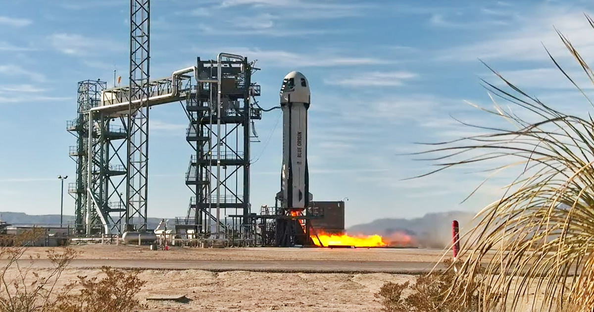
Launch of Blue Origin’s New Shepard suborbital rocket system on Feb. 4, 2025. During the flight test, the capsule at the top detached from the booster and spun at approximately 11 rpm to simulate lunar gravity for the NASA-supported payloads inside.
Blue Origin
The old saying — “Practice makes perfect!” — applies to the Moon too. On Tuesday, NASA gave 17 technologies, instruments, and experiments the chance to practice being on the Moon… without actually going there. Instead, it was a flight test aboard a vehicle adapted to simulate lunar gravity for approximately two minutes.
The test began on February 4, 2025, with the 10:00 a.m. CST launch of Blue Origin’s New Shepard reusable suborbital rocket system in West Texas. With support from NASA’s Flight Opportunities program, the company, headquartered in Kent, Washington, enhanced the flight capabilities of its New Shepard capsule to replicate the Moon’s gravity — which is about one-sixth of Earth’s — during suborbital flight.
“Commercial companies are critical to helping NASA prepare for missions to the Moon and beyond,” said Danielle McCulloch, program executive of the agency’s Flight Opportunities program. “The more similar a test environment is to a mission’s operating environment, the better. So, we provided substantial support to this flight test to expand the available vehicle capabilities, helping ensure technologies are ready for lunar exploration.”
NASA’s Flight Opportunities program not only secured “seats” for the technologies aboard this flight — for 16 payloads inside the capsule plus one mounted externally — but also contributed to New Shepard’s upgrades to provide the environment needed to advance their readiness for the Moon and other space exploration missions.
“An extended period of simulated lunar gravity is an important test regime for NASA,” said Greg Peters, program manager for Flight Opportunities. “It’s crucial to reducing risk for innovations that might one day go to the lunar surface.”
Watch highlights from the Feb. 4, 2025 lunar gravity flight test.
Blue Origin
One example is the LUCI (Lunar-g Combustion Investigation) payload, which seeks to understand material flammability on the Moon compared to Earth. This is an important component of astronaut safety in habitats on the Moon and could inform the design of potential combustion devices there. With support from the Moon to Mars Program Office within the Exploration Systems Development Mission Directorate, researchers at NASA’s Glenn Research Center in Cleveland, together with Voyager Technologies, designed LUCI to measure flame propagation directly during the Blue Origin flight.
The rest of the NASA-supported payloads on this Blue Origin flight included seven from NASA’s Game Changing Development program that seek to mitigate the impact of lunar dust and to perform construction and excavation on the lunar surface. Three other NASA payloads tested instruments to detect subsurface water on the Moon as well as to study flow physics and phase changes in lunar gravity. Rounding out the manifest were payloads from Draper, Honeybee Robotics, Purdue University, and the University of California in Santa Barbara.
Flight Opportunities is part of the agency’s Space Technology Mission Directorate and is managed at NASA’s Armstrong Flight Research Center.
By Nancy Pekar, NASA’s Flight Opportunities program
Preparations for Next Moonwalk Simulations Underway (and Underwater)
Jeremy Frank, left, and Caleb Adams, right, discuss software developed by NASA’s Distributed Spacecraft Autonomy project. The software runs on spacecraft computers, currently housed on a test rack at NASA’s Ames Research Center in California’s Silicon Valley, and depicts a spacecraft swarm virtually flying in lunar orbit to provide autonomous position navigation and timing services at the Moon.
NASA/Brandon Torres Navarrete
Talk amongst yourselves, get on the same page, and work together to get the job done! This “pep talk” roughly describes how new NASA technology works within satellite swarms. This technology, called Distributed Spacecraft Autonomy (DSA), allows individual spacecraft to make independent decisions while collaborating with each other to achieve common goals – all without human input.
NASA researchers have achievedmultiple firsts in tests of such swarm technology as part of the agency’s DSA project. Managed at NASA’s Ames Research Center in California’s Silicon Valley, the DSA project develops software tools critical for future autonomous, distributed, and intelligent swarms that will need to interact with each other to achieve complex mission objectives.
“The Distributed Spacecraft Autonomy technology is very unique,” said Caleb Adams, DSA project manager at NASA Ames. “The software provides the satellite swarm with the science objective and the ‘smarts’ to get it done.”
What AreDistributed Space Missions?
Distributed space missions rely on interactions between multiple spacecraft to achieve mission goals. Such missions can deliver better data to researchers and ensure continuous availability of critical spacecraft systems.
Typically, spacecraft in swarms are individually commanded and controlled by mission operators on the ground. As the number of spacecraft and the complexity of their tasks increase to meet new constellation mission designs, “hands-on” management of individual spacecraft becomes unfeasible.
Distributing autonomy across a group of interacting spacecraft allows for all spacecraft in a swarm to make decisions and is resistant to individual spacecraft failures.
The DSA team advanced swarm technology through two main efforts: the development of software for small spacecraft that was demonstrated in space during NASA’s Starling mission, which involved four CubeSat satellites operating as a swarm to test autonomous collaboration and operation with minimal human operation, and a scalability study of a simulated spacecraft swarm in a virtual lunar orbit.
Experimenting With DSA in Low Earth Orbit
The team gave Starling a challenging job: a fast-paced study of Earth’s ionosphere – where Earth’s atmosphere meets space – to show the swarm’s ability to collaborate and optimize science observations. The swarm decided what science to do on their own with no pre-programmed science observations from ground operators.
“We did not tell the spacecraft how to do their science,” said Adams. “The DSA team figured out what science Starling did only after the experiment was completed. That has never been done before and it’s very exciting!”
The accomplishments of DSA onboard Starling include the first fully distributed autonomous operation of multiple spacecraft, the first use of space-to-space communications to autonomously share status information between multiple spacecraft, the first demonstration of fully distributed reactive operations onboard multiple spacecraft, the first use of a general-purpose automated reasoning system onboard a spacecraft, and the first use of fully distributed automated planning onboard multiple spacecraft.
During the demonstration, which took place between August 2023 and May 2024, Starling’s swarm of spacecraft received GPS signals that pass through the ionosphere and reveal interesting – often fleeting – features for the swarm to focus on. Because the spacecraft constantly change position relative to each other, the GPS satellites, and the ionospheric environment, they needed to exchange information rapidly to stay on task.
Each Starling satellite analyzed and acted on its best results individually. When new information reached each spacecraft, new observation and action plans were analyzed, continuously enabling the swarm to adapt quickly to changing situations.
“Reaching the project goal of demonstrating the first fully autonomous distributed space mission was made possible by the DSA team’s development of distributed autonomy software that allowed the spacecraft to work together seamlessly,” Adams continued.
Caleb Adams, Distributed Spacecraft Autonomy project manager, monitors testing alongside the test racks containing 100 spacecraft computers at NASA’s Ames Research Center in California’s Silicon Valley. The DSA project develops and demonstrates software to enhance multi-spacecraft mission adaptability, efficiently allocate tasks between spacecraft using ad-hoc networking, and enable human-swarm commanding of distributed space missions.
NASA/Brandon Torres Navarrete
Scaling Up Swarms in Virtual Lunar Orbit
The DSA ground-based scalability study was a simulation that placed virtual small spacecraft and rack-mounted small spacecraft flight computers in virtual lunar orbit. This simulation was designed to test the swarm’s ability to provide position, navigation, and timing services at the Moon. Similar to what the GPS system does on Earth, this technology could equip missions to the Moon with affordable navigation capabilities, and could one day help pinpoint the location of objects or astronauts on the lunar surface.
The DSA lunar Position, Navigation, and Timing study demonstrated scalability of the swarm in a simulated environment. Over a two-year period, the team ran close to one hundred tests of more complex coordination between multiple spacecraft computers in both low- and high-altitude lunar orbit and showed that a swarm of up to 60 spacecraft is feasible.
The team is further developing DSA’s capabilities to allow mission operators to interact with even larger swarms – hundreds of spacecraft – as a single entity.
Distributed Spacecraft Autonomy’s accomplishments mark a significant milestone in advancing autonomous distributed space systems that will make new types of science and exploration possible.
NASA Ames leads the Distributed Spacecraft Autonomy and Starling projects. NASA’s Game Changing Development program within the agency’s Space Technology Mission Directorate provides funding for the DSA experiment. NASA’s Small Spacecraft Technology program within the Space Technology Mission Directorate funds and manages the Starling mission and the DSA project.
NASA has awarded Dynamic Aviation Group Inc. of Bridgewater, Virginia, the Commercial Aviation Services contract to support the agency’s Airborne Science Program. The program provides aircraft and technology to further science and advance the use of Earth observing satellite data, making NASA data about our home planet and innovations accessible to all.
This is an indefinite-delivery/indefinite-quantity firm-fixed-price contract with a maximum potential value of $13.5 million. The period of performance began Friday, Jan. 31, and continues through Jan. 30, 2030.
Under this contract, the company will provide ground and flight crews and services using modified commercial aircraft, including a Beechcraft King Air B200 and Beechcraft King Air A90. Work will include mechanical and electrical engineering services for instrument integration and de-integration, flight planning and real-time tracking, project execution, as well as technical feasibility assessments and cost estimation. Aircraft modifications may include instrumented nosecones, viewing ports, inlets, computing systems, and satellite communications capabilities.
This work is essential for NASA to conduct airborne science missions, develop and validate earth system models, and support satellite payload calibration. NASA’s Ames Research Center in California’s Silicon Valley will administer the agency-wide contract on behalf of the Airborne Science Program in the Earth Science Division at NASA Headquarters in Washington.
To learn more about NASA and agency programs, visit:
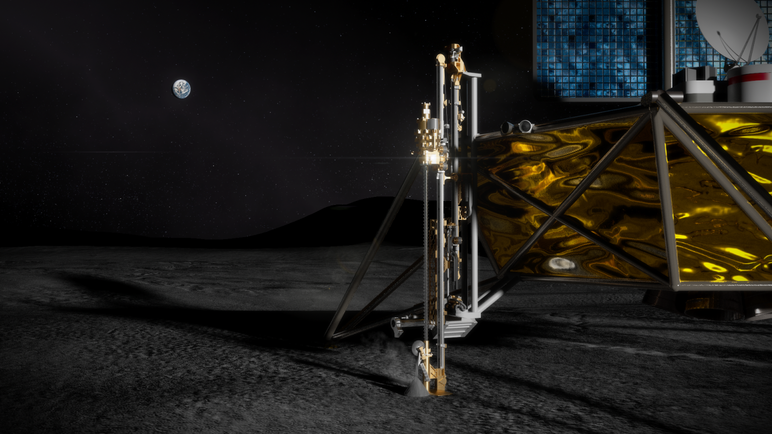
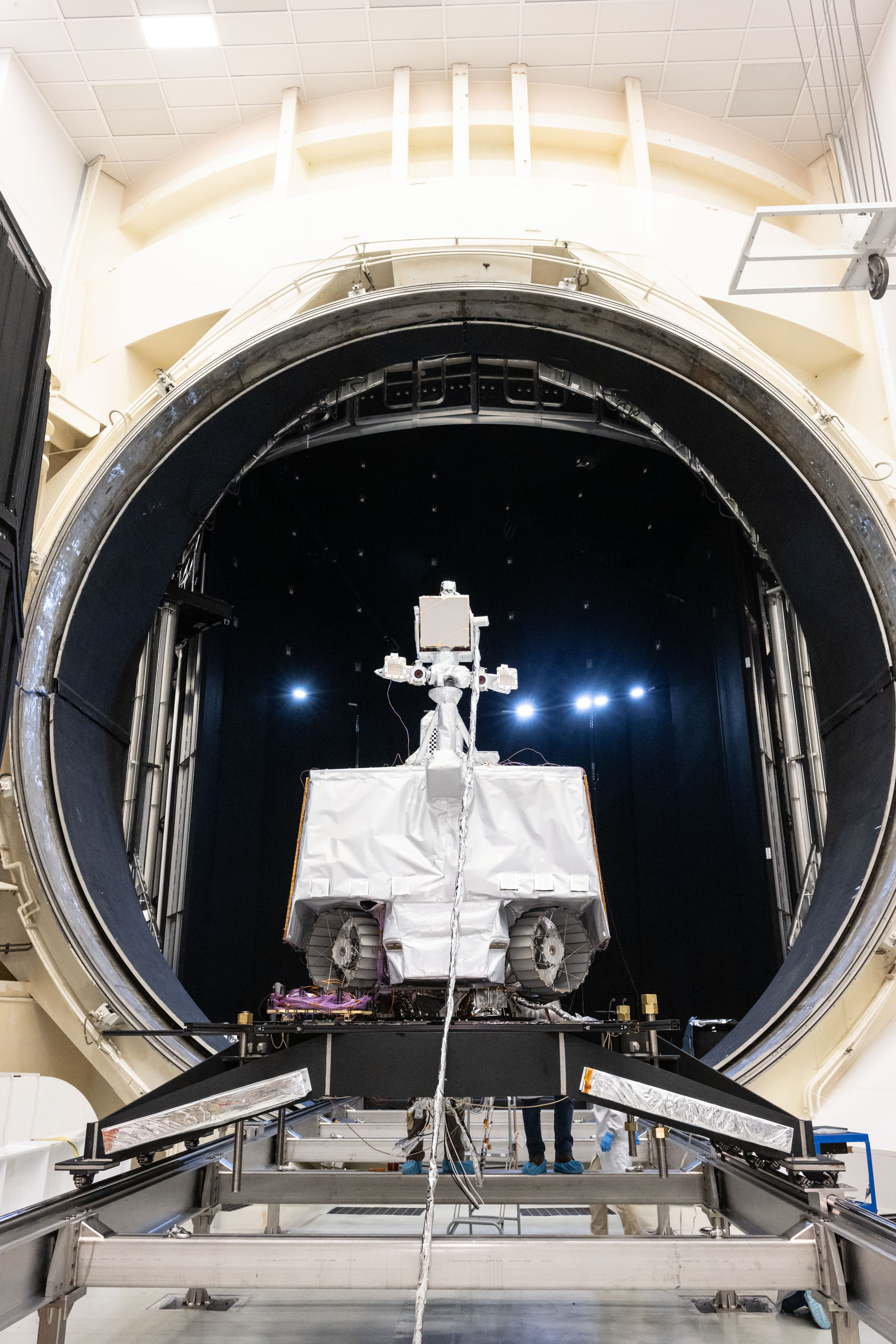
NASA’s VIPER (Volatiles Investigating Polar Exploration Rover) sits outside a testing chamber after completing its thermal vacuum testing in the fall of 2024. Credit: NASA/JSC David DeHoyos
Editor’s note: This release was updated on Feb. 4, 2025, to reflect a change in the deadline for when responses to the proposal are due.
To advance plans of securing a public/private partnership and land and operate NASA’s VIPER (Volatiles Investigating Polar Exploration Rover) mission on the Moon in collaboration with industry the agency announced Monday it is seeking U.S. proposals. As part of the agency’s Artemis campaign, instruments on VIPER will demonstrate U.S. industry’s ability to search for ice on the lunar surface and collect science data.
The Announcement for Partnership Proposal contains proposal instructions and evaluation criteria for a new Lunar Volatiles Science Partnership. Responses are due Monday, March 3. After evaluating submissions, any selections by the agency will require respondents to submit a second, more detailed, proposal. NASA is expected to make a decision on the VIPER mission this summer.
“Moving forward with a VIPER partnership offers NASA a unique opportunity to engage with the private sector,” said Nicky Fox, associate administrator in the Science Mission Directorate at NASA Headquarters in Washington. “Such a partnership provides the opportunity for NASA to collect VIPER science that could tell us more about water on the Moon, while advancing commercial lunar landing capabilities and resource prospecting possibilities.”
This new announcement comes after NASA issued a Request for Information on Aug. 9, 2024, to seek interest from American companies and institutions in conducting a mission using the agency’s VIPER Moon rover after the program was canceled in July 2024.
Any partnership would work under a Cooperative Research and Development Agreement. This type of partnership allows both NASA and an industry partner to contribute services, technology, and hardware to the collaboration.
As part of an agreement, NASA would contribute the existing VIPER rover as-is. Potential partners would need to arrange for the integration and successful landing of the rover on the Moon, conduct a science/exploration campaign, and disseminate VIPER-generated science data. The partner may not disassemble the rover and use its instruments or parts separately from the VIPER mission. NASA’s selection approach will favor proposals that enable data from the mission’s science instruments to be shared openly with anyone who wishes to use it.
“Being selected for the VIPER partnership would benefit any company interested in advancing their lunar landing and surface operations capabilities,” said Joel Kearns, deputy associate administrator for exploration in the Science Mission Directorate. “This solicitation seeks proposals that clearly describe what is needed to successfully land and operate the rover, and invites industry to propose their own complementary science goals and approaches. NASA is looking forward to partnering with U.S. industry to meet the challenges of performing volatiles science in the lunar environment.”
The Moon is a cornerstone for solar system science and exoplanet studies. In addition to helping inform where ice exists on the Moon for potential future astronauts, understanding our nearest neighbor helps us understand how it has evolved and what processes shaped its surface.


/Curiosity%20Rover%20(MSL)%20(Clean).png)